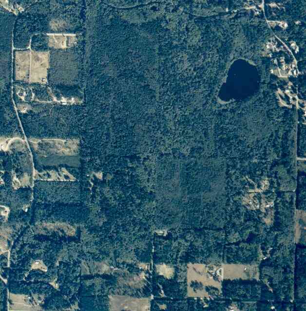
The above September 1997 aerial photo of this section of Camano is from http://www.islandcounty.net/publicworks/digitalphotos/mainmap.htm
The above September 1997 aerial photo of this section of Camano is from
http://www.islandcounty.net/publicworks/digitalphotos/mainmap.htm
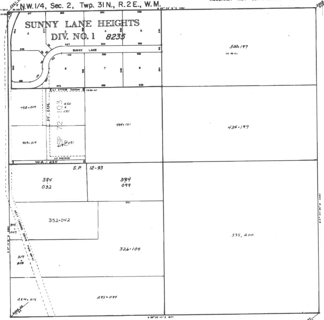
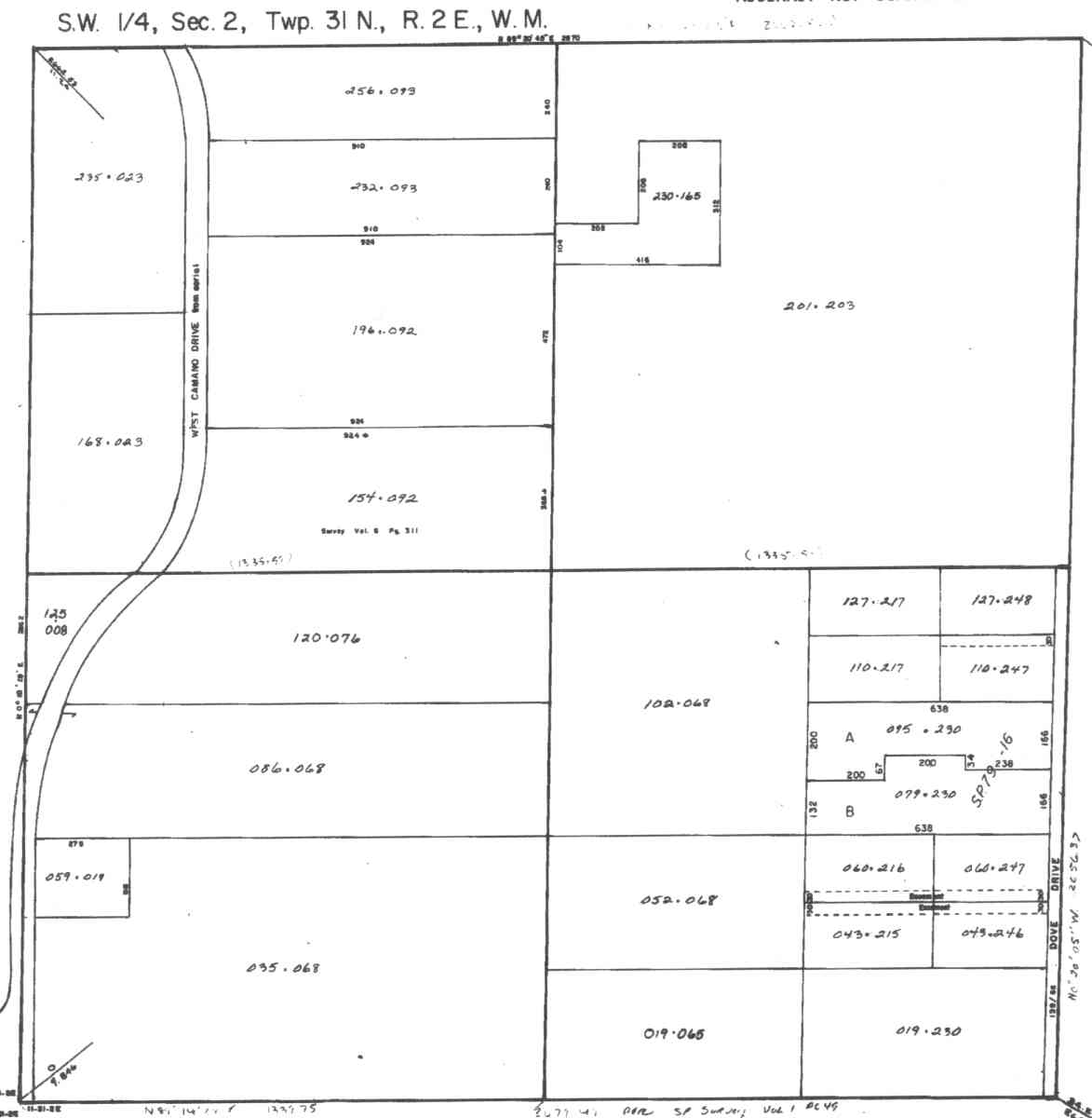
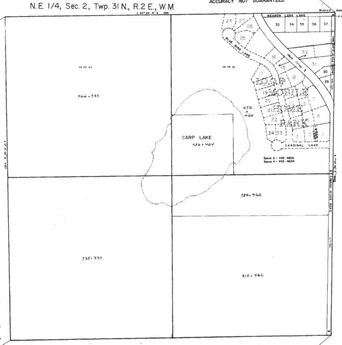
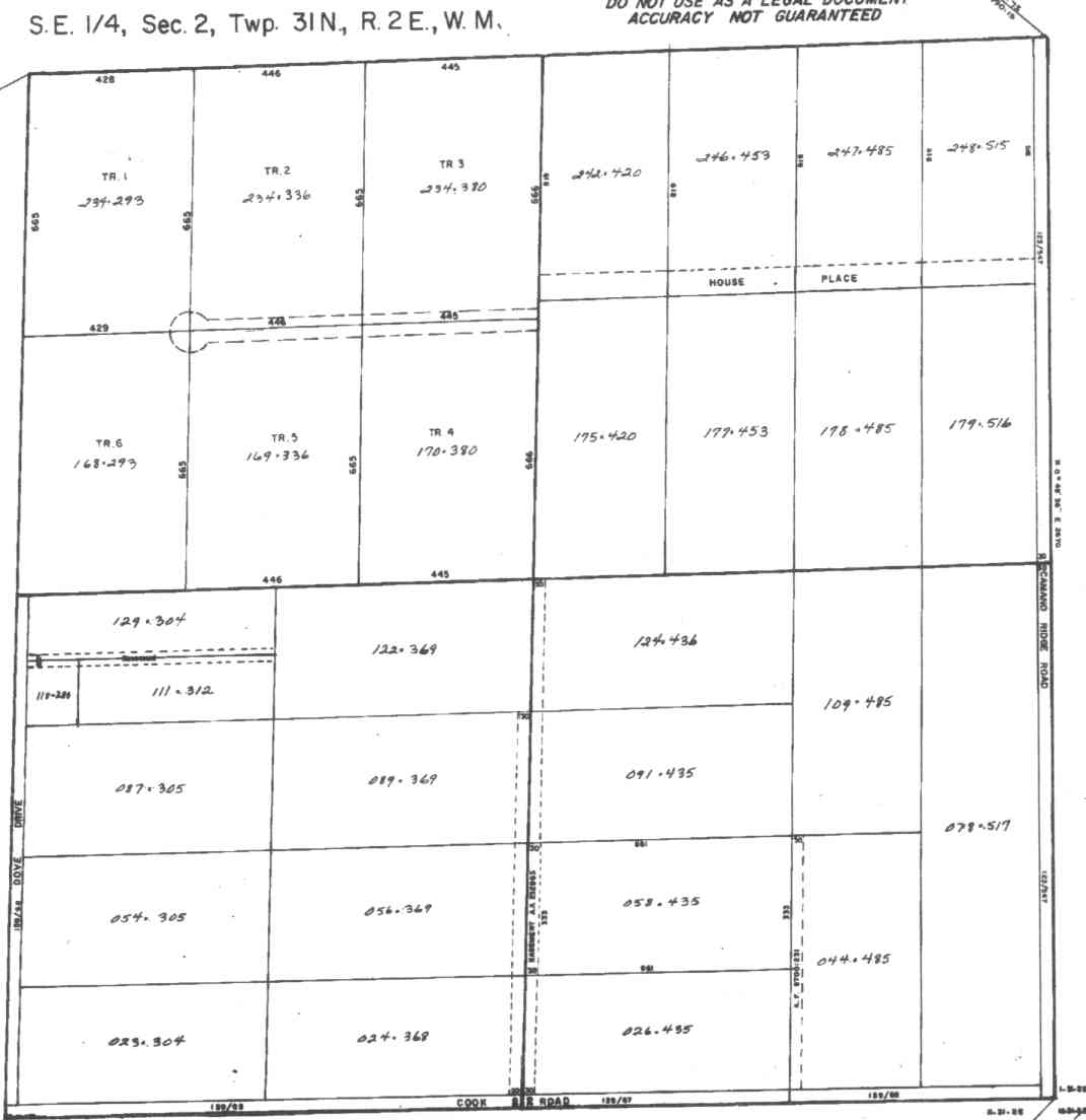
A square system of surveying was ordained by the Continental Congress on May 20, 1785. Within each township (6 miles X 6 miles), are 36 sections. Each section of 640 acres is one mile square (5,280 feet X 5,280 feet). Each quarter section is 160 acres (2,640 feet X 2,640 feet). Most long straight roads and acreage pieces of property have north-south, east-west property lines.
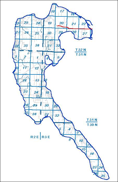
Click on the below Camano section map numbers, to go to a page with a aerial photo, and to 1/4 section property parcel maps.
Click on the below Camano section map numbers, to go to a page with Camano Island 2005 assessor data, 1/4 section parcel maps, and aerial photos.
Below are the 26 well reports for this section of Camano, from the December 2004 Washington State Department of Ecology Well log website. Included below is who the well was drilled for, the well depth, and when the well was drilled. At the well log website,
http://apps.ecy.wa.gov/welllog/ more detailed information is available, like the well drillers name, water temperature(sometimes), and soil profile depths.
The below well logs information is from the Washington State Department of Ecology Well log website.
http://apps.ecy.wa.gov/welllog/

MARVIN DAY
Public Land Survey: NE, NE, S-02, T-31-N, R-02-E
County: ISLAND
Well Log ID: 81728
Well Diameter: 6 (inches), Well Depth: 151 (feet)
Well Type: Water, Well Completion Date: 6/11/1981
TED KITCHNER
Public Land Survey: NE, NE, S-02, T-31-N, R-02-E, Tax Parcel Number: R231025003620
County: ISLAND, Well Address: 539 CARP LAKE RD, CAMANO ISLAND 98282
Well Log ID: 378887, Well Tag ID: ALA259, Notice of Intent Number: WE02020
Well Diameter: 6 (inches), Well Depth: 106.5 (feet)
Well Type: Water, Well Completion Date: 4/1/2004, Well Log Received Date: 4/28/2004
BRIAN ELDER
Public Land Survey: NE, NW, S-02, T-31-N, R-02-E
County: ISLAND, Well Address: SUNNY LN, CAMANO ISLAND
Well Log ID: 75327 , Notice of Intent Number: W054366
Well Diameter: 6 (inches), Well Depth: 400 (feet)
Well Type: Water, Well Completion Date: 6/18/1997, Well Log Received Date: 6/23/1997
JEFF PALMER
Public Land Survey: SW, NW, S-02, T-31-N, R-02-E
County: ISLAND
Well Log ID: 79510 , Notice of Intent Number: 026406
Well Diameter: 6 (inches), Well Depth: 360 (feet)
Well Type: Water, Well Completion Date: 6/7/1989, Well Log Received Date: 6/28/1989
RUBEN DELOS REYES
Public Land Survey: SW, NW, S-02, T-31-N, R-02-E
County: ISLAND, Well Address: NW CAMANO, CAMANO ISLAND, 98292
Well Log ID: 84199 , Notice of Intent Number: 070889
Well Diameter: 6 (inches), Well Depth: 425 (feet)
Well Type: Water, Well Completion Date: 4/28/1993
SHELDA BERNAT
Public Land Survey: SW, NW, S-02, T-31-N, R-02-E
County: ISLAND, Well Address: 177 S W CAMANO DR, CAMANO ISLAND
Well Log ID: 84479 , Notice of Intent Number: W043571
Well Diameter: 6 (inches), Well Depth: 360 (feet)
Well Type: Water, Well Completion Date: 9/30/1994, Well Log Received Date: 10/11/1994
ROY HARTING
Public Land Survey: SW, NW, S-02, T-31-N, R-02-E, Tax Parcel Number: R23102-419-0190
County: ISLAND, Well Address: 80 QUIET PL, CAMANO ISLAND
Well Log ID: 314563, Well Tag ID: ACY392, Notice of Intent Number: W156101
Well Diameter: 6 (inches), Well Depth: 80 (feet)
Well Type: Water, Well Completion Date: 8/27/2001, Well Log Received Date: 10/12/2001
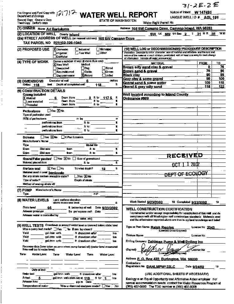
ART BARTOLOME
Public Land Survey: SW, NW, S-02, T-31-N, R-02-E, Tax Parcel Number: R23102-326-1040
County: ISLAND, Well Address: 165 W CAMANO DR
Well Log ID: 343784, Well Tag ID: AGL191, Notice of Intent Number: W147491
Well Diameter: 6 (inches), Well Depth: 118 (feet)
Well Type: Water, Well Completion Date: 9/23/2002, Well Log Received Date: 10/11/2002
MIKE WAYNER
Public Land Survey: (blank), SE, S-02, T-31-N, R-02-E
County: ISLAND
Well Log ID: 82177
Well Diameter: 6 (inches), Well Depth: 306 (feet)
Well Type: Water, Well Completion Date: 7/18/1982
ED VAN GER PEN
Public Land Survey: NE, SE, S-02, T-31-N, R-02-E
County: ISLAND, Well Address: 453 W 245 S CAMANO RIDGE RD, CAMANO ISLAND, 98292
Well Log ID: 77563 , Notice of Intent Number: 070357
Well Diameter: 6 (inches), Well Depth: 335 (feet)
Well Type: Water, Well Completion Date: 8/6/1990
MIKE WIMMER
Public Land Survey: NE, SE, S-02, T-31-N, R-02-E
County: ISLAND, Well Address: 445 W 2455, CAMANO ISLAND, 98292
Well Log ID: 82181 , Notice of Intent Number: 070380
Well Diameter: 6 (inches), Well Depth: 220 (feet)
Well Type: Water, Well Completion Date: 11/8/1990
GUS WALDMANN
Public Land Survey: NE, SE, S-02, T-31-N, R-02-E
County: ISLAND, Well Address: HOME PLACE RD
Well Log ID: 86783, Well Tag ID: ABN025, Notice of Intent Number: W016699
Well Diameter: 6 (inches), Well Depth: 340 (feet)
Well Type: Water, Well Completion Date: 10/28/1994, Well Log Received Date: 11/1/1994
EDWARD MUELLER
Public Land Survey: NE, SE, S-02, T-31-N, R-02-E, Tax Parcel Number: R23102-242-4200
County: ISLAND, Well Address: 480 HOUSE PL, CAMANO ISLAND, 98292
Well Log ID: 325794, Well Tag ID: AFJ795, Notice of Intent Number: W118533
Well Diameter: 6 (inches), Well Depth: 256 (feet)
Well Type: Water, Well Completion Date: 1/9/2002, Well Log Received Date: 2/15/2002
SUZAN HICKS
Public Land Survey: NE, SE, S-02, T-31-N, R-02-E
County: ISLAND, Well Address: 226 S CAMANO RIDGE, CAMANO ISLAND
Well Log ID: 380979, Well Tag ID: AHE025, Notice of Intent Number: W147341
Well Diameter: 6 (inches), Well Depth: 29 (feet)
Well Type: Water, Well Completion Date: 5/21/2004, Well Log Received Date: 6/4/2004
RICHARD KOCH
Public Land Survey: SE, SE, S-02, T-31-N, R-02-E
County: ISLAND, Well Address: XXX GREGORY RD, CAMANO ISLAND
Well Log ID: 304111, Well Tag ID: AFJ752, Notice of Intent Number: W098084
Well Diameter: 6 (inches), Well Depth: 209 (feet)
Well Type: Water, Well Completion Date: 7/10/2000, Well Log Received Date: 11/8/2000
JIM SCAPPINI
Public Land Survey: SW, SE, S-02, T-31-N, R-02-E
County: ISLAND, Well Address: 303 S DOVE DR, CAMANO ISLAND, 98292
Well Log ID: 79863
Well Diameter: 6 (inches), Well Depth: 400 (feet)
Well Type: Water, Well Completion Date: 1/13/1993, Well Log Received Date: 2/2/1993
JEFF WESTLAND
Public Land Survey: SW, SE, S-02, T-31-N, R-02-E
County: ISLAND, Well Address: 367 DOVE DR, CAMANO ISLAND
Well Log ID: 87414, Well Tag ID: ACY302, Notice of Intent Number: W099102
Well Diameter: 6 (inches), Well Depth: 360 (feet)
Well Type: Water, Well Completion Date: 9/23/1997, Well Log Received Date: 10/15/1997
MARY CAMPBELL
Public Land Survey: NE, SW, S-02, T-31-N, R-02-E
County: ISLAND, Well Address: W CAMANO
Well Log ID: 81755 , Notice of Intent Number: 023263
Well Diameter: 6 (inches), Well Depth: 363 (feet)
Well Type: Water, Well Completion Date: 8/18/1989, Well Log Received Date: 8/24/1989
MARY CAMPBELL
Public Land Survey: NE, SW, S-02, T-31-N, R-02-E
County: ISLAND
Well Log ID: 81756
Well Diameter: 6 (inches), Well Depth: 640 (feet)
Well Type: Water, Well Completion Date: 7/22/1988
JULIE RAYMOND
Public Land Survey: NW, SW, S-02, T-31-N, R-02-E
County: ISLAND, Well Address: 248 SW CAMANO DR, CAMANO ISLAND
Well Log ID: 93905 , Notice of Intent Number: W009030
Well Diameter: 6 (inches), Well Depth: 300 (feet)
Well Type: Water, Well Completion Date: 8/25/1993, Well Log Received Date: 8/30/1993
WILLIAM SANDE
Public Land Survey: NW, SW, S-02, T-31-N, R-02-E, Tax Parcel Number: R23102-120-0760
County: ISLAND, Well Address: 275 S WEST CAMANO DR, CAMANO ISLAND, 98282
Well Log ID: 369678, Well Tag ID: ABO949, Notice of Intent Number: W153725
Well Diameter: 6 (inches), Well Depth: 382 (feet)
Well Type: Water, Well Completion Date: 7/25/2003, Well Log Received Date: 9/29/2003
KEN WATKINS, JR.
Public Land Survey: SE, SW, S-02, T-31-N, R-02-E
County: ISLAND, Well Address: COOK AND DOVE RD, CAMANO ISLAND, 98292
Well Log ID: 80733 , Notice of Intent Number: W043596
Well Diameter: 6 (inches), Well Depth: 360 (feet)
Well Type: Water, Well Completion Date: 7/3/1995, Well Log Received Date: 8/8/1995
RICK FRED
Public Land Survey: SE, SW, S-02, T-31-N, R-02-E
County: ISLAND, Well Address: 613 W DOVE DR, CAMANO ISLAND, 98292
Well Log ID: 87413, Well Tag ID: ACY301, Notice of Intent Number: W099101
Well Diameter: 6 (inches), Well Depth: 375 (feet)
Well Type: Water, Well Completion Date: 8/14/1997, Well Log Received Date: 8/26/1997
JIM WOOLBERT
Public Land Survey: SE, SW, S-02, T-31-N, R-02-E
County: ISLAND, Well Address: XXX COOK ROAD, CAMANO ISLAND, WA
Well Log ID: 248132, Well Tag ID: AEF928, Notice of Intent Number: W120904
Well Diameter: 6 (inches), Well Depth: 205 (feet)
Well Type: Water, Well Completion Date: 2/20/2000, Well Log Received Date: 3/9/2000
JIM WOOLBERT
Public Land Survey: SE, SW, S-02, T-31-N, R-02-E
County: ISLAND, Well Address: 3XX HAMPTON CT, CAMANO ISLAND
Well Log ID: 374122, Well Tag ID: AGK761, Notice of Intent Number: W120926
Well Diameter: 6 (inches), Well Depth: 208 (feet)
Well Type: Water, Well Completion Date: 1/22/2004, Well Log Received Date: 1/29/2004
BAXTER SIMS
Public Land Survey: SW, SW, S-02, T-31-N, R-02-E
County: ISLAND
Well Log ID: 74649
Well Diameter: 6 (inches), Well Depth: 435 (feet)
Well Type: Water, Well Completion Date: 11/21/1983
wr23202swcamanodrbartolome2002dahlman
wr23202swcamanodrbartolome2002dahlman