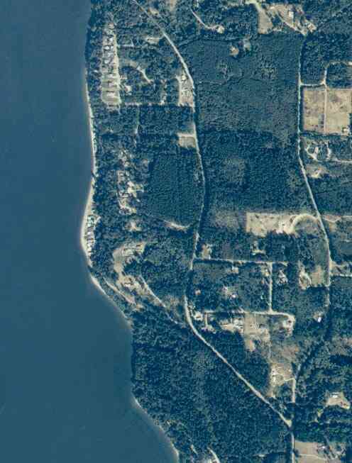
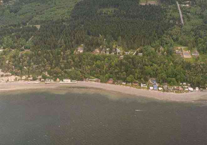
The above September 1997 aerial photo of this section of Camano is from http://www.islandcounty.net/publicworks/digitalphotos/mainmap.htm
The above September 1997 aerial photo of this section of Camano is from
http://www.islandcounty.net/publicworks/digitalphotos/mainmap.htm
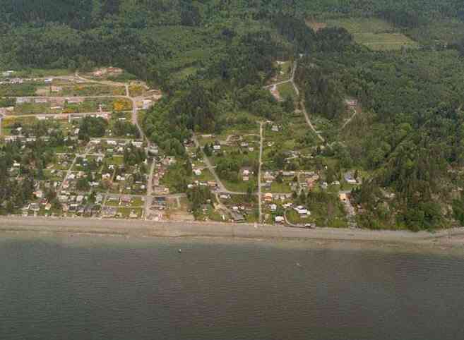
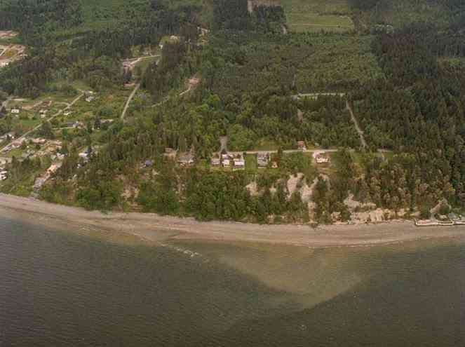
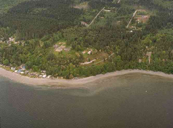
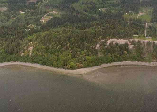
The below 5/8/1993 2:30:00 PM aerial photos are from:
http://apps.ecy.wa.gov/shorephotos
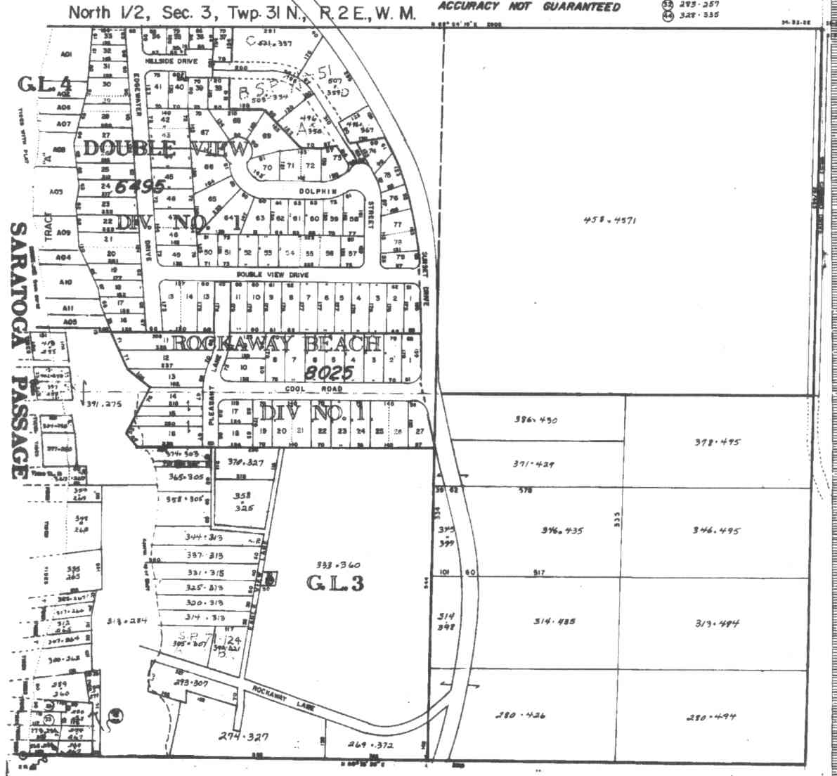
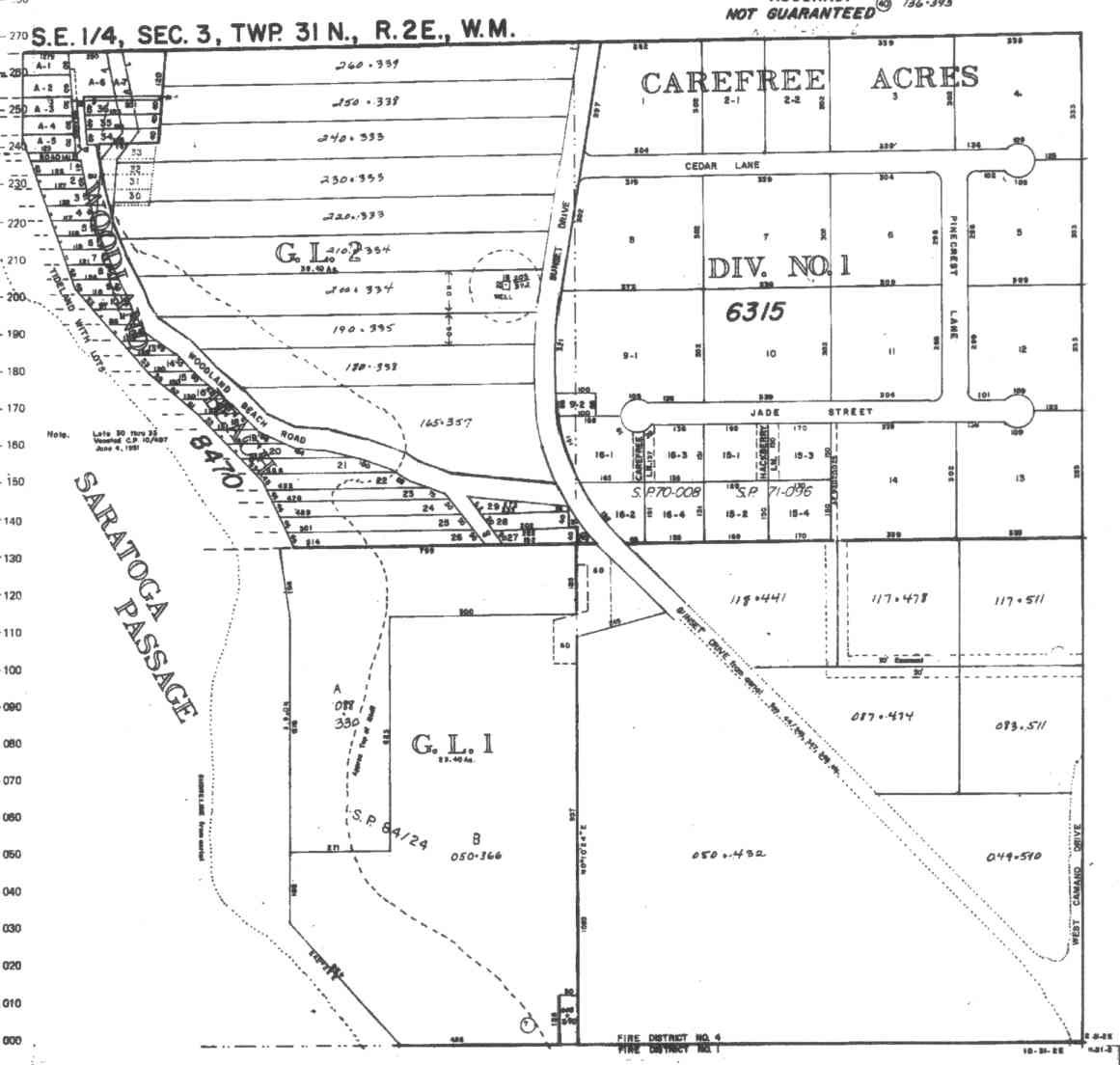
A square system of surveying was ordained by the Continental Congress on May 20, 1785. Within each township (6 miles X 6 miles), are 36 sections. Each section of 640 acres is one mile square (5,280 feet X 5,280 feet). Each quarter section is 160 acres (2,640 feet X 2,640 feet). Most long straight roads and acreage pieces of property have north-south, east-west property lines.
Click on the below Camano section map numbers, to go to a page with Camano Island 2005 assessor data, 1/4 section parcel maps, and aerial photos.
Below are the 24 well reports for this section of Camano, from the December 2004 Washington State Department of Ecology Well log website. Included below is who the well was drilled for, the well depth, and when the well was drilled. At the well log website,
http://apps.ecy.wa.gov/welllog/ more detailed information is available, like the well drillers name, water temperature(sometimes), and soil profile depths.
The below well logs information is from the Washington State Department of Ecology Well log website.
http://apps.ecy.wa.gov/welllog/
 <888>
<888>

HARRY WESTERMAN
Public Land Survey: NE, NE, S-03, T-31-N, R-02-E
County: ISLAND
Well Log ID: 78830
Well Diameter: 6 (inches), Well Depth: 418 (feet)
Well Type: Water, Well Completion Date: 3/22/1978
DOUBLE VIEW COMM ASSOC
Public Land Survey: NW, NE, S-03, T-31-N, R-02-E, Tax Parcel Number: S6495-00-00A01-0
County: ISLAND, Well Address: LOT 4
Well Log ID: 335363 , Notice of Intent Number: W159855
Well Diameter: 6 (inches), Well Depth: 270 (feet)
Well Type: Water, Well Completion Date: 8/13/2001, Well Log Received Date: 8/17/2001
JOHN VERHEY
Public Land Survey: NW, NE, S-03, T-31-N, R-02-E
County: ISLAND
Well Log ID: 351097
Well Diameter: 6 (inches), Well Depth: 270 (feet)
Well Type: Water, Well Completion Date: 9/9/1963
JOHN H KORTLEVER
Public Land Survey: NW, NE, S-03, T-31-N, R-02-E
County: ISLAND
Well Log ID: 351098
Well Diameter: 8 (inches), Well Depth: 405 (feet)
Well Type: Water, Well Completion Date: 12/29/1969
ROB HUTCHING
Public Land Survey: SE, NE, S-03, T-31-N, R-02-E
County: ISLAND
Well Log ID: 83602
Well Diameter: 6 (inches), Well Depth: 440 (feet)
Well Type: Water, Well Completion Date: 2/15/1986, Well Log Received Date: 4/2/1986
CAMANO ISLAND
Public Land Survey: SE, NE, S-03, T-31-N, R-02-E
County: ISLAND
Well Log ID: 113137 , Notice of Intent Number: 800163
Well Diameter: (blank) , Well Depth: 50 (feet)
Well Type: Water, Well Completion Date: 5/21/1998, Well Log Received Date: 6/8/1998
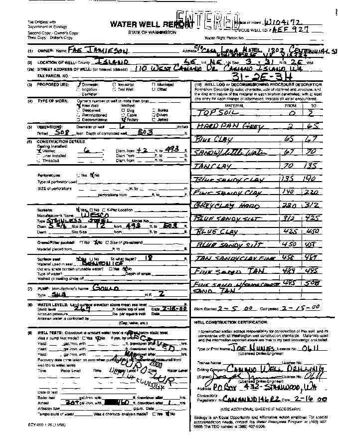
FAE JAMIESON
Public Land Survey: SE, NE, S-03, T-31-N, R-02-E
County: ISLAND, Well Address: 110 WEST CAMANO DRIVE, CAMANO ISLAND, WA
Well Log ID: 248133, Well Tag ID: AEF927, Notice of Intent Number: W104172
Well Diameter: 6 (inches), Well Depth: 503 (feet)
Well Type: Water, Well Completion Date: 2/15/2000, Well Log Received Date: 3/7/2000
DONALD BAIRD
Public Land Survey: SW, NE, S-03, T-31-N, R-02-E
County: ISLAND, Well Address: 951 W ROCKAWAY HEIGHTS LN
Well Log ID: 77171 , Notice of Intent Number: W041587
Well Diameter: 6 (inches), Well Depth: 351 (feet)
Well Type: Water, Well Completion Date: 5/24/1994, Well Log Received Date: 6/6/1994
DONALD BAIRD
Public Land Survey: SW, NE, S-03, T-31-N, R-02-E
County: ISLAND
Well Log ID: 285175
Well Diameter: 6 (inches), Well Depth: 340 (feet)
Well Type: Water
DONALD BAIRD
Public Land Survey: SW, NE, S-03, T-31-N, R-02-E
County: ISLAND
Well Log ID: 285176
Well Diameter: 6 (inches), Well Depth: 340 (feet)
Well Type: Water
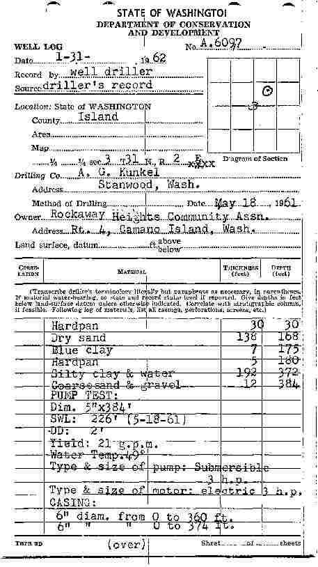
ROCKAWAY HEIGHTS COMMUNITY ASSN
Public Land Survey: SW, NE, S-03, T-31-N, R-02-E
County: ISLAND
Well Log ID: 351099
Well Diameter: 5 (inches), Well Depth: 384 (feet)
Well Type: Water, Well Completion Date: 5/18/1961
CHUCK BOLENDER
Public Land Survey: NW, NW, S-03, T-31-N, R-02-E
County: ISLAND, Well Address: 154 S ROCKAWAY LN, CAMANO ISLAND
Well Log ID: 75861
Well Diameter: 36 (inches), Well Depth: 19 (feet)
Well Type: Water, Well Completion Date: 8/10/1992, Well Log Received Date: 8/24/1992
CHUCK BOLINGER
Public Land Survey: NW, NW, S-03, T-31-N, R-02-E
County: ISLAND, Well Address: 154 S ROCKAWAY LN, CAMANO ISLAND
Well Log ID: 75862 , Notice of Intent Number: 070370
Well Diameter: 6 (inches), Well Depth: 175 (feet)
Well Type: Water, Well Completion Date: 10/20/1990
MICHAEL KELLER
Public Land Survey: NW, NW, S-03, T-31-N, R-02-E
County: ISLAND, Well Address: 134 S ROCKAWAY LN, CAMANO ISLAND
Well Log ID: 81921 , Notice of Intent Number: 070378
Well Diameter: 6 (inches), Well Depth: 165 (feet)
Well Type: Water, Well Completion Date: 11/5/1990
MICHAEL KELLER
Public Land Survey: NW, NW, S-03, T-31-N, R-02-E
County: ISLAND, Well Address: 134 ROCKAWAY BEACH LN, CAMANO ISLAND, 98282
Well Log ID: 305298 , Notice of Intent Number: A002182
Well Diameter: 36 (inches), Well Depth: 24 (feet)
Well Type: Decommissioned, Well Completion Date: 4/18/2001, Well Log Received Date: 6/1/2001
CHARLES SWOOPE
Public Land Survey: SE, NW, S-03, T-31-N, R-02-E
County: ISLAND, Well Address: 160 WOODLAND BEACH RD N, CAMANO ISLAND, 98292
Well Log ID: 75759 , Notice of Intent Number: 048066
Well Diameter: 6 (inches), Well Depth: 50 (feet)
Well Type: Water, Well Completion Date: 3/31/1992, Well Log Received Date: 5/4/1992
CAMANO ISLAND
Public Land Survey: SE, NW, S-03, T-31-N, R-02-E
County: ISLAND
Well Log ID: 113138 , Notice of Intent Number: 800163
Well Diameter: (blank) , Well Depth: 20 (feet)
Well Type: Water, Well Completion Date: 5/21/1998, Well Log Received Date: 6/8/1998
CAMANO ISLAND
Public Land Survey: SE, NW, S-03, T-31-N, R-02-E
County: ISLAND
Well Log ID: 113139 , Notice of Intent Number: 800163
Well Diameter: (blank) , Well Depth: 28 (feet)
Well Type: Water, Well Completion Date: 5/21/1998, Well Log Received Date: 6/8/1998
DAVE PETRZELKEA
Public Land Survey: NW, SE, S-03, T-31-N, R-02-E
County: ISLAND, Well Address: 2145 WOODLAND BEACH RD
Well Log ID: 76538 , Notice of Intent Number: 076622
Well Diameter: 18 (inches), Well Depth: 38 (feet)
Well Type: Water, Well Completion Date: 3/1/1991, Well Log Received Date: 4/18/1991
GILLEY HALE
Public Land Survey: NW, SE, S-03, T-31-N, R-02-E, Tax Parcel Number: S8470-00-00002-0
County: ISLAND, Well Address: SUNSET AND S WOODLAND BEACH, CAMANO ISLAND
Well Log ID: 78474, Well Tag ID: AKY730
Well Diameter: 6 (inches), Well Depth: 410 (feet)
Well Type: Water, Well Completion Date: 6/30/1987
ROY NEILSON
Public Land Survey: NW, SE, S-03, T-31-N, R-02-E
County: ISLAND, Well Address: 204 S WOODLAND BEACH RD
Well Log ID: 84186 , Notice of Intent Number: 024411
Well Diameter: 6 (inches), Well Depth: 38 (feet)
Well Type: Water, Well Completion Date: 6/1/1989, Well Log Received Date: 7/10/1989
SAM BRIX
Public Land Survey: NW, SE, S-03, T-31-N, R-02-E
County: ISLAND, Well Address: 1985 WOODLAND BEACH RD
Well Log ID: 84300 , Notice of Intent Number: 078369
Well Diameter: 18 (inches), Well Depth: 33 (feet)
Well Type: Water, Well Completion Date: 3/5/1991, Well Log Received Date: 4/18/1991
ALICE PUTNAM
Public Land Survey: SE, SE, S-03, T-31-N, R-02-E
County: ISLAND
Well Log ID: 74320
Well Diameter: (blank)
Well Type: Water, Well Completion Date: 7/6/1981, Well Log Received Date: 11/9/1981
DARRYL JONES
Public Land Survey: SE, SE, S-03, T-31-N, R-02-E
County: ISLAND, Well Address: 328 SW CAMANO DR
Well Log ID: 378894, Well Tag ID: AHH318, Notice of Intent Number: W153595
Well Diameter: 6 (inches), Well Depth: 447 (feet)
Well Type: Water, Well Completion Date: 4/7/2004, Well Log Received Date: 4/27/2004
wr23203jamieson2000nunes
wr23203rockaway1961kunkel