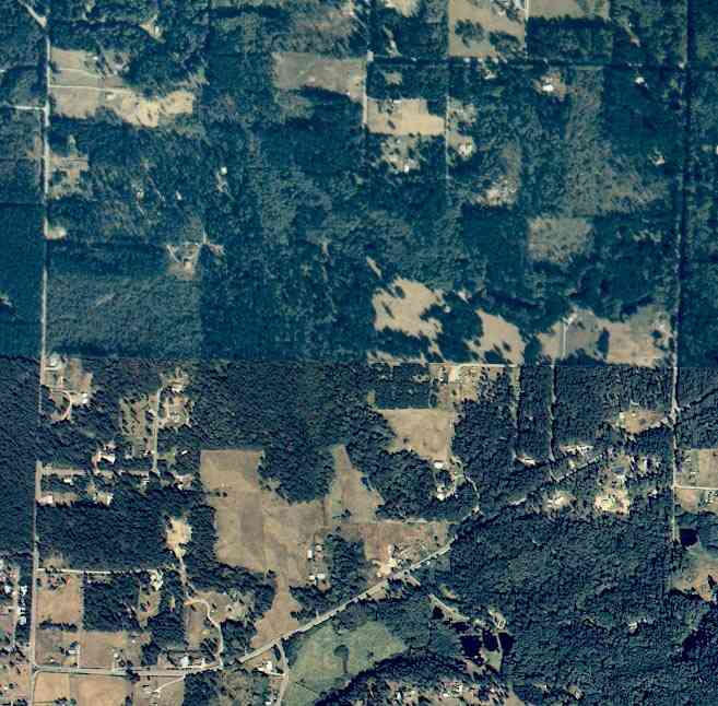
The above September 1997 aerial photo of this section of Camano is from http://www.islandcounty.net/publicworks/digitalphotos/mainmap.htm
The above September 1997 aerial photo of this section of Camano is from
http://www.islandcounty.net/publicworks/digitalphotos/mainmap.htm
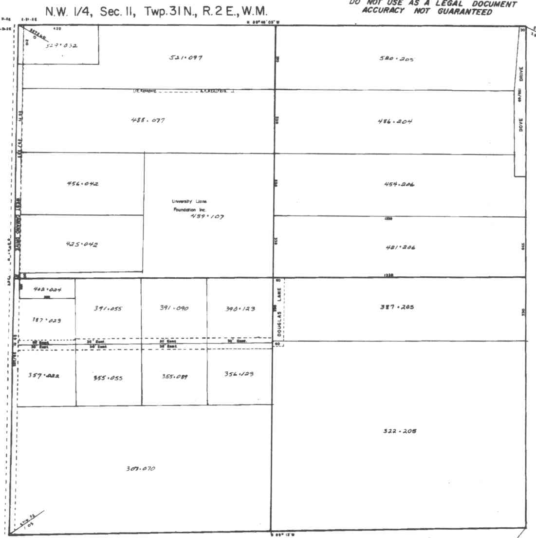
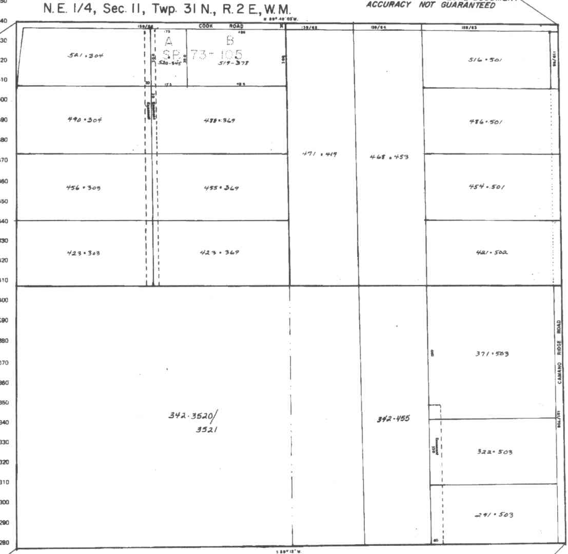
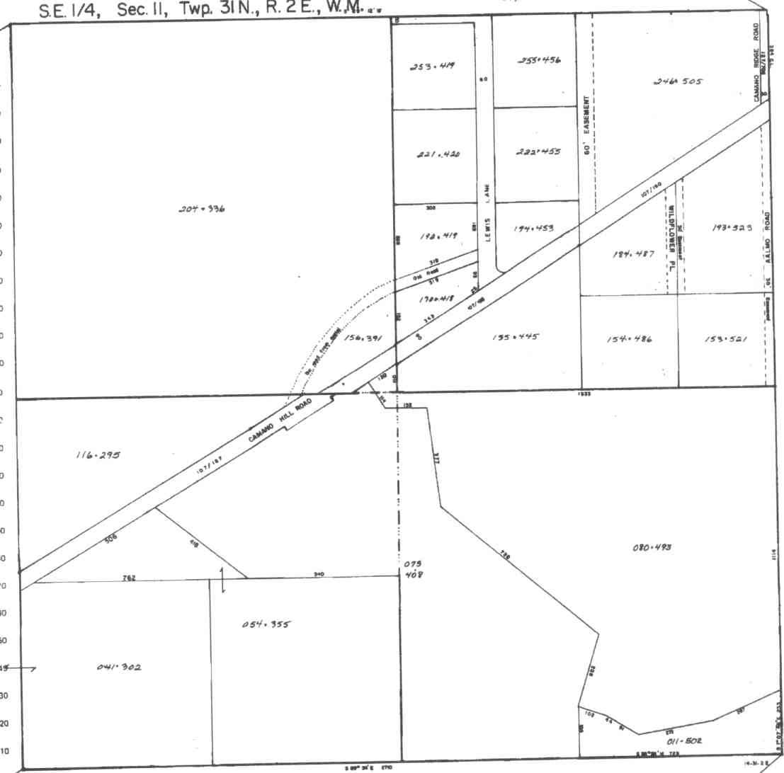
A square system of surveying was ordained by the Continental Congress on May 20, 1785. Within each township (6 miles X 6 miles), are 36 sections. Each section of 640 acres is one mile square (5,280 feet X 5,280 feet). Each quarter section is 160 acres (2,640 feet X 2,640 feet). Most long straight roads and acreage pieces of property have north-south, east-west property lines.
Click on the below Camano section map numbers, to go to a page with Camano Island 2005 assessor data, 1/4 section parcel maps, and aerial photos.
Below are the 26 well reports for this section of Camano, from the December 2004 Washington State Department of Ecology Well log website. Included below is who the well was drilled for, the well depth, and when the well was drilled. At the well log website,
http://apps.ecy.wa.gov/welllog/ more detailed information is available, like the well drillers name, water temperature(sometimes), and soil profile depths.
The below well logs information is from the Washington State Department of Ecology Well log website.
http://apps.ecy.wa.gov/welllog/

 <888>
<888>

GUSTARCE TILLMAN
Public Land Survey: NE, NE, S-11, T-31-N, R-02-E
County: ISLAND, Well Address: 425 W 350TH ST, CAMANO ISLAND
Well Log ID: 78703
Well Diameter: 6 (inches), Well Depth: 310 (feet)
Well Type: Water, Well Completion Date: 5/4/1992, Well Log Received Date: 8/3/1992
FRANK MICHL
Public Land Survey: NE, NE, S-11, T-31-N, R-02-E, Tax Parcel Number: R23111-421-5020
County: ISLAND, Well Address: 490 CAMANO RIDGE RD
Well Log ID: 334685, Well Tag ID: AGL158, Notice of Intent Number: W147466
Well Diameter: 6 (inches), Well Depth: 158 (feet)
Well Type: Water, Well Completion Date: 5/21/2002, Well Log Received Date: 5/29/2002
DON GLAD
Public Land Survey: NW, NE, S-11, T-31-N, R-02-E
County: ISLAND, Well Address: POACH AND COOK RD
Well Log ID: 77072 , Notice of Intent Number: 070882
Well Diameter: 6 (inches), Well Depth: 345 (feet)
Well Type: Water, Well Completion Date: 4/15/1993, Well Log Received Date: 5/19/1993
LORRIS OHNSAGER
Public Land Survey: NW, NE, S-11, T-31-N, R-02-E
County: ISLAND
Well Log ID: 81372
Well Diameter: 6 (inches), Well Depth: 110 (feet)
Well Type: Water
ART JOHNS
Public Land Survey: SE, NE, S-11, T-31-N, R-02-E
County: ISLAND, Well Address: 592 S RIDGE RD, CAMANO ISLAND
Well Log ID: 74519 , Notice of Intent Number: 026749
Well Diameter: 6 (inches), Well Depth: 123 (feet)
Well Type: Water, Well Completion Date: 12/28/1989, Well Log Received Date: 1/16/1990
DON STRATTON
Public Land Survey: SE, NE, S-11, T-31-N, R-02-E
County: ISLAND, Well Address: 657 S LEWIS LN, CAMANO ISLAND
Well Log ID: 77151 , Notice of Intent Number: 026750
Well Diameter: 6 (inches), Well Depth: 140 (feet)
Well Type: Water, Well Completion Date: 1/9/1990, Well Log Received Date: 1/29/1990
EDWARD FULCHER
Public Land Survey: SE, NE, S-11, T-31-N, R-02-E
County: ISLAND, Well Address: LEWIS LN, CAMANO ISLAND, 98292
Well Log ID: 77602 , Notice of Intent Number: W043552
Well Diameter: 6 (inches), Well Depth: 180 (feet)
Well Type: Water, Well Completion Date: 5/25/1994, Well Log Received Date: 6/22/1994
KEVIN JOHNS
Public Land Survey: SE, NE, S-11, T-31-N, R-02-E
County: ISLAND
Well Log ID: 80800 , Notice of Intent Number: W010474
Well Diameter: 6 (inches), Well Depth: 291 (feet)
Well Type: Water, Well Completion Date: 2/3/1994, Well Log Received Date: 3/2/1994
JACK HARDCASTLE
Public Land Survey: SE, NE, S-11, T-31-N, R-02-E, Tax Parcel Number: R23111-371-5030
County: ISLAND, Well Address: XXX CAMANO RIDGE RD, CAMANO 92282
Well Log ID: 389864, Well Tag ID: ABO985, Notice of Intent Number: W175664
Well Diameter: 6 (inches), Well Depth: 176 (feet)
Well Type: Water, Well Completion Date: 8/27/2004, Well Log Received Date: 10/1/2004
ROYCE NATOLI
Public Land Survey: SW, NE, S-11, T-31-N, R-02-E
County: ISLAND, Well Address: LEWIS LN, CAMANO ISLAND
Well Log ID: 84198
Well Diameter: 6 (inches), Well Depth: 161 (feet)
Well Type: Water, Well Completion Date: 2/21/1990, Well Log Received Date: 3/2/1990
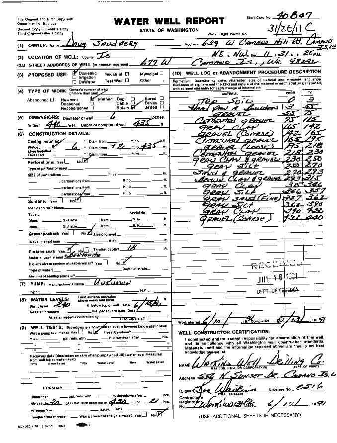
DOUG SANDBERG
Public Land Survey: NE, NW, S-11, T-31-N, R-02-E
County: ISLAND, Well Address: 677 W, CAMANO ISLAND, 98292
Well Log ID: 77294 , Notice of Intent Number: 040847
Well Diameter: 6 (inches), Well Depth: 435 (feet)
Well Type: Water, Well Completion Date: 6/13/1991, Well Log Received Date: 7/18/1991
NORTHWEST BUILDERS
Public Land Survey: NE, NW, S-11, T-31-N, R-02-E, Tax Parcel Number: 231115202050
County: ISLAND, Well Address: XXX COOK ROAD
Well Log ID: 326331, Well Tag ID: AFJ770
Well Diameter: 6 (inches), Well Depth: 330 (feet)
Well Type: Water , Well Log Received Date: 3/27/2001
DAVE DIAZ
Public Land Survey: NE, NW, S-11, T-31-N, R-02-E
County: ISLAND, Well Address: 456 DOVE DR, CAMANO ISLAND
Well Log ID: 386473, Well Tag ID: AKY981, Notice of Intent Number: W182228
Well Diameter: 6 (inches), Well Depth: 271 (feet)
Well Type: Water, Well Completion Date: 8/14/2004, Well Log Received Date: 9/13/2004
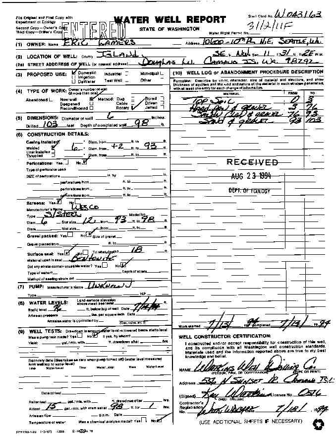
ERIC WAMERS
Public Land Survey: SE, NW, S-11, T-31-N, R-02-E
County: ISLAND, Well Address: DOUGLAS LN, CAMANO ISLAND, 98292
Well Log ID: 77720 , Notice of Intent Number: W043163
Well Diameter: 6 (inches), Well Depth: 98 (feet)
Well Type: Water, Well Completion Date: 7/14/1994, Well Log Received Date: 8/23/1994
JOHN ROSS
Public Land Survey: SW, NW, S-11, T-31-N, R-02-E
County: ISLAND
Well Log ID: 80301
Well Diameter: 6 (inches), Well Depth: 260 (feet)
Well Type: Water, Well Completion Date: 6/1/1979
JOHN ROSS
Public Land Survey: SW, NW, S-11, T-31-N, R-02-E
County: ISLAND
Well Log ID: 80302
Well Diameter: 6 (inches), Well Depth: 265 (feet)
Well Type: Water, Well Completion Date: 6/9/1979
DARREN WILLIAMS
Public Land Survey: SW, NW, S-11, T-31-N, R-02-E, Tax Parcel Number: R231113550890
County: ISLAND, Well Address: XXXX W. CAMANO DRIVE, CAMANO ISLAND, WA
Well Log ID: 248136, Well Tag ID: AEF932, Notice of Intent Number: W120907
Well Diameter: 6 (inches), Well Depth: 378 (feet)
Well Type: Water, Well Completion Date: 5/27/2000
JASON JENSEN
Public Land Survey: SW, NW, S-11, T-31-N, R-02-E, Tax Parcel Number: R23111-387-0230
County: ISLAND, Well Address: 788 DOUGLESS LN, CAMANO ISLAND 98282
Well Log ID: 348018, Well Tag ID: ABO922, Notice of Intent Number: W153711
Well Diameter: 6 (inches), Well Depth: 241 (feet)
Well Type: Water, Well Completion Date: 10/19/2002, Well Log Received Date: 12/9/2002
JAMES MC ELROY
Public Land Survey: NE, SE, S-11, T-31-N, R-02-E
County: ISLAND, Well Address: 662 WILD FLOWER PL, CAMANO ISLAND, 98692
Well Log ID: 79308 , Notice of Intent Number: 040824
Well Diameter: 6 (inches), Well Depth: 318 (feet)
Well Type: Water, Well Completion Date: 3/9/1991, Well Log Received Date: 3/15/1991
JEFF & CINDY WITTMAN
Public Land Survey: NE, SE, S-11, T-31-N, R-02-E
County: ISLAND, Well Address: WILDFLOWER PL
Well Log ID: 79451 , Notice of Intent Number: W090860
Well Diameter: 6 (inches), Well Depth: 345 (feet)
Well Type: Water, Well Completion Date: 5/30/1997
MACE GULLIFORD
Public Land Survey: NE, SE, S-11, T-31-N, R-02-E
County: ISLAND, Well Address: PEACH RD, CAMANO ISLAND, 98292
Well Log ID: 81517 , Notice of Intent Number: 070879
Well Diameter: 6 (inches), Well Depth: 120 (feet)
Well Type: Water, Well Completion Date: 3/18/1993, Well Log Received Date: 4/19/1993
TOM SANDE
Public Land Survey: NE, SE, S-11, T-31-N, R-02-E
County: ISLAND, Well Address: 606 S LEWIS LN, CAMANO ISLAND, 98292
Well Log ID: 85344 , Notice of Intent Number: 040866
Well Diameter: 6 (inches), Well Depth: 170 (feet)
Well Type: Water, Well Completion Date: 7/10/1991, Well Log Received Date: 7/18/1991
GARY JENSEN
Public Land Survey: NW, SE, S-11, T-31-N, R-02-E
County: ISLAND, Well Address: LEWIS LN, CAMANO ISLAND, 98292
Well Log ID: 78198 , Notice of Intent Number: W043582
Well Diameter: 6 (inches), Well Depth: 220 (feet)
Well Type: Water, Well Completion Date: 12/30/1994, Well Log Received Date: 1/13/1995
JAMES JENNINGS
Public Land Survey: SE, SE, S-11, T-31-N, R-02-E
County: ISLAND, Well Address: 503 W CAMANO HILL RD, CAMANO ISLAND
Well Log ID: 79290 , Notice of Intent Number: A000897
Well Diameter: 6 (inches), Well Depth: 330 (feet)
Well Type: Decommissioned, Well Completion Date: 10/15/1991, Well Log Received Date: 10/21/1991
JOE & ARRON FIRCHAU
Public Land Survey: NE, SW, S-11, T-31-N, R-02-E
County: ISLAND, Well Address: CHERYL ANN DR, CAMANO ISLAND
Well Log ID: 377831, Well Tag ID: AHH316, Notice of Intent Number: W153525
Well Diameter: 6 (inches), Well Depth: 485 (feet)
Well Type: Water, Well Completion Date: 3/18/2004, Well Log Received Date: 3/31/2004
KEVIN JOHNS
Public Land Survey: NW, SW, S-11, T-31-N, R-02-E
County: ISLAND, Well Address: 536 W CAMANO HILL RD, CAMANO ISLAND
Well Log ID: 80801 , Notice of Intent Number: 070374
Well Diameter: 6 (inches), Well Depth: 172 (feet)
Well Type: Water, Well Completion Date: 10/21/1990
wr23111douglaslnwamers1994watkins
wr23111wcamanosandberg1991watkins