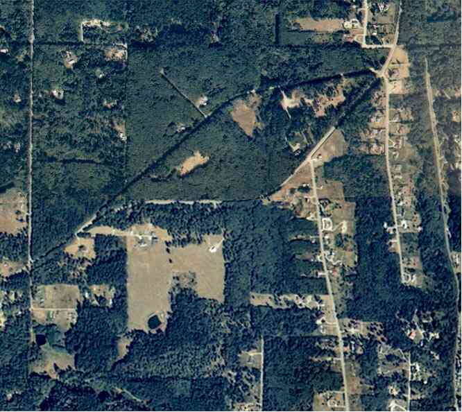
The above September 1997 aerial photo of this section of Camano is from http://www.islandcounty.net/publicworks/digitalphotos/mainmap.htm
The above September 1997 aerial photo of this section of Camano is from
http://www.islandcounty.net/publicworks/digitalphotos/mainmap.htm
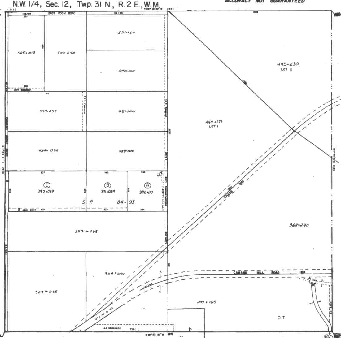
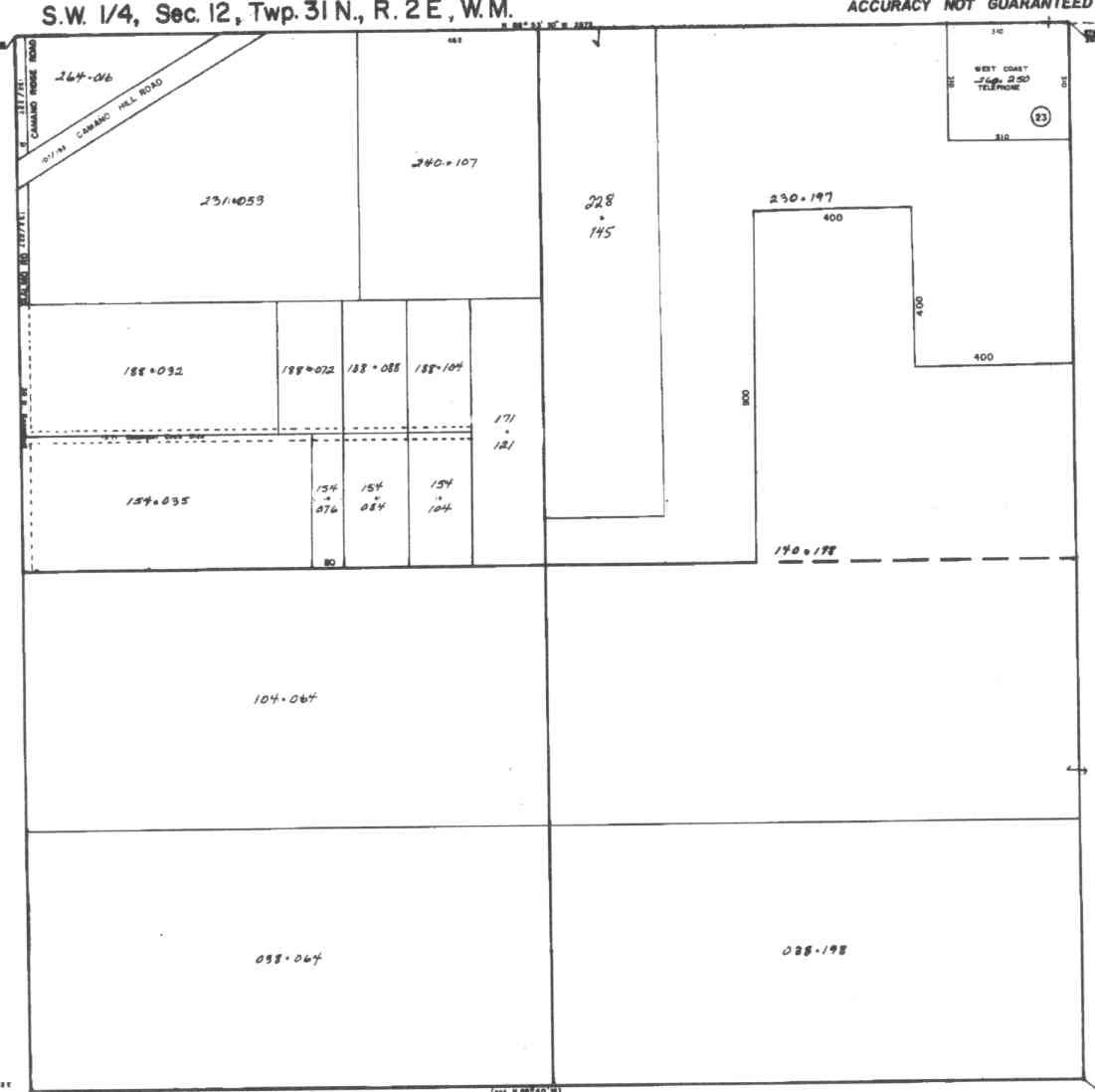
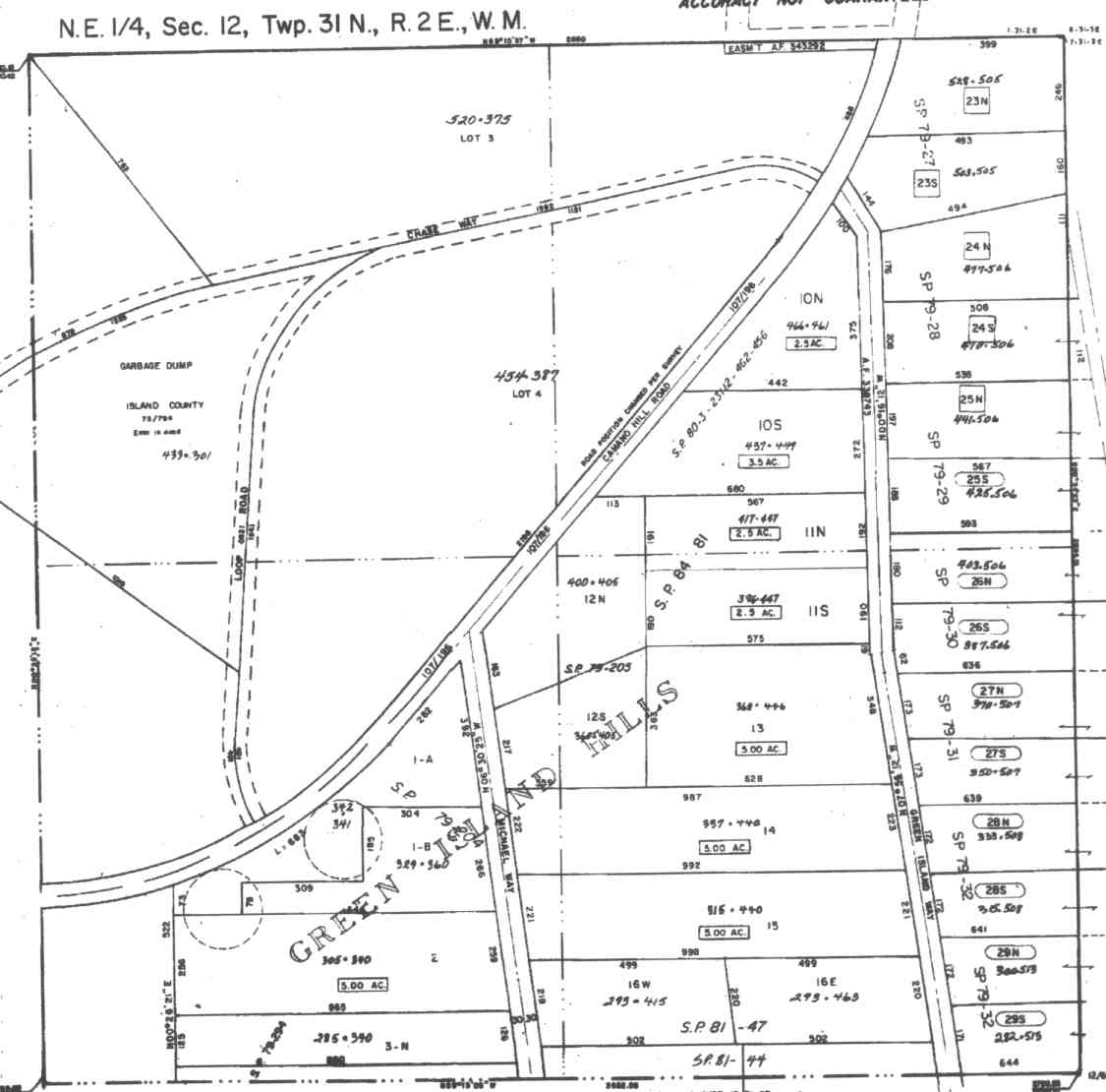
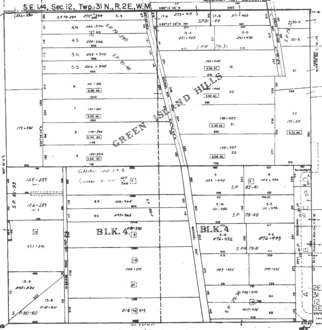
A square system of surveying was ordained by the Continental Congress on May 20, 1785. Within each township (6 miles X 6 miles), are 36 sections. Each section of 640 acres is one mile square (5,280 feet X 5,280 feet). Each quarter section is 160 acres (2,640 feet X 2,640 feet). Most long straight roads and acreage pieces of property have north-south, east-west property lines.
Click on the below Camano section map numbers, to go to a page with Camano Island 2005 assessor data, 1/4 section parcel maps, and aerial photos.
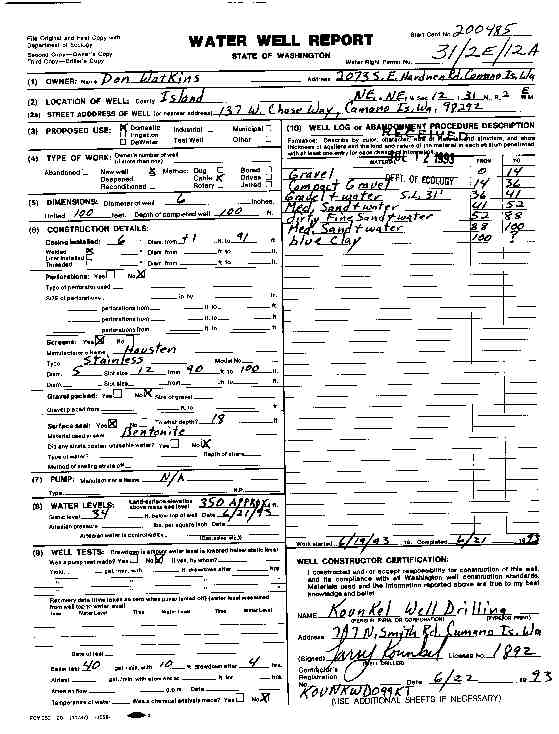
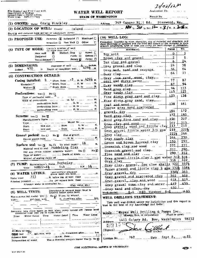
Below are the 15 well reports for this section of Camano, from the December 2004 Washington State Department of Ecology Well log website. Included below is who the well was drilled for, the well depth, and when the well was drilled. At the well log website,
http://apps.ecy.wa.gov/welllog/ more detailed information is available, like the well drillers name, water temperature(sometimes), and soil profile depths.
The below well logs information is from the Washington State Department of Ecology Well log website.
http://apps.ecy.wa.gov/welllog/
 <888>
<888>

DON WATKINS
Public Land Survey: NE, NE, S-12, T-31-N, R-02-E
County: ISLAND, Well Address: 137 W CHASE WY, CAMANO ISLAND, 98292
Well Log ID: 77163 , Notice of Intent Number: 200485
Well Diameter: 6 (inches), Well Depth: 100 (feet)
Well Type: Water, Well Completion Date: 6/21/1993, Well Log Received Date: 7/12/1993
GREEN ISLAND HILLS COMM
Public Land Survey: NE, NE, S-12, T-31-N, R-02-E
County: ISLAND, Well Address: CAMANO HILL
Well Log ID: 371527, Well Tag ID: AKY882, Notice of Intent Number: W167856
Well Diameter: 8 (inches), Well Depth: 122.5 (feet)
Well Type: Water, Well Completion Date: 10/1/2003, Well Log Received Date: 1/13/2003
MARLA BELLMER
Public Land Survey: NE, NW, S-12, T-31-N, R-02-E
County: ISLAND, Well Address: 248 W CHASE WY, CAMANO ISLAND
Well Log ID: 81677 , Notice of Intent Number: 040914
Well Diameter: 6 (inches), Well Depth: 134 (feet)
Well Type: Water, Well Completion Date: 1/18/1991
BILL DOUGLAS
Public Land Survey: NW, NW, S-12, T-31-N, R-02-E
County: ISLAND, Well Address: 459 S SAILOR LN, CAMANO ISLAND
Well Log ID: 74816 , Notice of Intent Number: 023253
Well Diameter: 6 (inches), Well Depth: 125 (feet)
Well Type: Water, Well Completion Date: 5/27/1989, Well Log Received Date: 6/5/1989
DONN ANDERSON
Public Land Survey: NW, NW, S-12, T-31-N, R-02-E
County: ISLAND
Well Log ID: 77215
Well Diameter: 36 (inches)
Well Type: Water, Well Completion Date: 12/11/1992, Well Log Received Date: 12/24/1992
GARY BAILEY
Public Land Survey: NW, NW, S-12, T-31-N, R-02-E
County: ISLAND, Well Address: 408 S SAYLOR LN, CAMANO ISLAND, 98292
Well Log ID: 78148 , Notice of Intent Number: 075129
Well Diameter: 6 (inches), Well Depth: 212 (feet)
Well Type: Water, Well Completion Date: 4/9/1991, Well Log Received Date: 5/20/1991
NADEEN HAROGDSON
Public Land Survey: NW, NW, S-12, T-31-N, R-02-E
County: ISLAND, Well Address: 387 E COOK RD, CAMANO ISLAND
Well Log ID: 82405 , Notice of Intent Number: 205451
Well Diameter: 6 (inches), Well Depth: 185 (feet)
Well Type: Water, Well Completion Date: 5/4/1993, Well Log Received Date: 5/18/1993
DOUG & KITTY HENNICK
Public Land Survey: SE, NW, S-12, T-31-N, R-02-E
County: ISLAND
Well Log ID: 77254
Well Diameter: 6 (inches), Well Depth: 160 (feet)
Well Type: Water, Well Completion Date: 7/15/1992, Well Log Received Date: 7/20/1992
KEVIN SUNBERG
Public Land Survey: SW, NW, S-12, T-31-N, R-02-E
County: ISLAND, Well Address: CAMANO HILL RD AND CAMANO RIDGE RD
Well Log ID: 86416, Well Tag ID: ABC737, Notice of Intent Number: W075097
Well Diameter: 6 (inches), Well Depth: 440 (feet)
Well Type: Water, Well Completion Date: 9/15/1998, Well Log Received Date: 10/16/1998
PETER KOLLOGN
Public Land Survey: SW, NW, S-12, T-31-N, R-02-E
County: ISLAND, Well Address: CAMANO RIDGE RD
Well Log ID: 87441, Well Tag ID: ACY712, Notice of Intent Number: W077579
Well Diameter: 6 (inches), Well Depth: 104 (feet)
Well Type: Water, Well Completion Date: 3/23/1998, Well Log Received Date: 3/30/1998
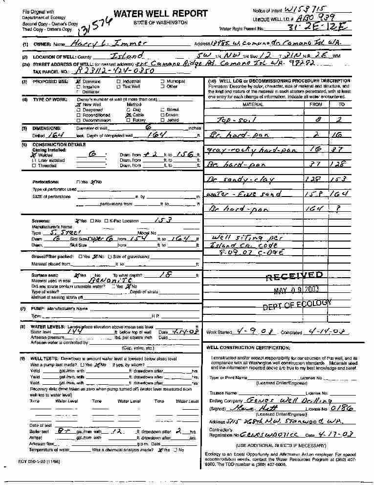
HARRY IMMER
Public Land Survey: SW, NW, S-12, T-31-N, R-02-E, Tax Parcel Number: R23112-424-0350
County: ISLAND, Well Address: XXX CAMANO RIDGE RD, CAMANO ISLAND
Well Log ID: 359609, Well Tag ID: ABO939, Notice of Intent Number: W153715
Well Diameter: 6 (inches), Well Depth: 164 (feet)
Well Type: Water, Well Completion Date: 4/14/2003, Well Log Received Date: 5/9/2003
KURT SMALLY
Public Land Survey: SW, NW, S-12, T-31-N, R-02-E
County: ISLAND, Well Address: 519 S CAMANO RIDGE RD
Well Log ID: 367893, Well Tag ID: AGF440, Notice of Intent Number: W156098
Well Diameter: 6 (inches), Well Depth: 180 (feet)
Well Type: Water, Well Completion Date: 8/15/2003, Well Log Received Date: 8/29/2003
GENERAL TELEPHONE
Public Land Survey: NE, SW, S-12, T-31-N, R-02-E
County: ISLAND
Well Log ID: 78317
Well Diameter: 6 (inches), Well Depth: 161 (feet)
Well Type: Water, Well Completion Date: 5/22/1973
CRAIG BINCKLEY
Public Land Survey: NW, SW, S-12, T-31-N, R-02-E
County: ISLAND
Well Log ID: 76105
Well Diameter: 6 (inches), Well Depth: 429 (feet)
Well Type: Water, Well Completion Date: 8/8/1983
GREG HANSON
Public Land Survey: NW, SW, S-12, T-31-N, R-02-E
County: ISLAND, Well Address: 661 AALMO RD, CAMANO ISLAND
Well Log ID: 78628
Well Diameter: 6 (inches), Well Depth: 354 (feet)
Well Type: Water, Well Completion Date: 1/29/1993, Well Log Received Date: 2/2/1993
wr23112chasewatkins1993kounkel
wr23112hillbinckley1983mayes
wr23112ridgeimmer2003gene