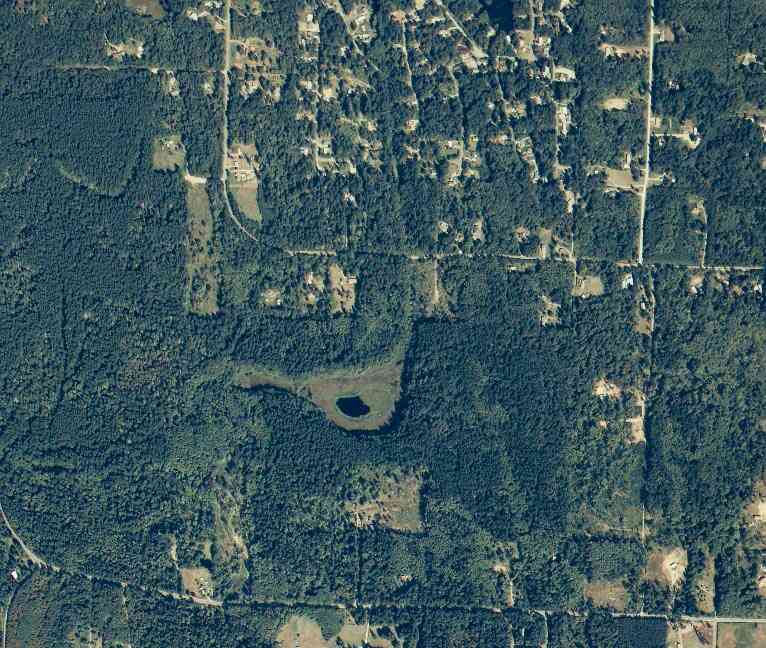
The above September 1997 aerial photo of this section of Camano is from http://www.islandcounty.net/publicworks/digitalphotos/mainmap.htm
The above September 1997 aerial photo of this section of Camano is from
http://www.islandcounty.net/publicworks/digitalphotos/mainmap.htm
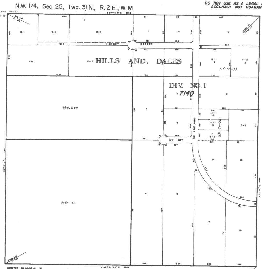
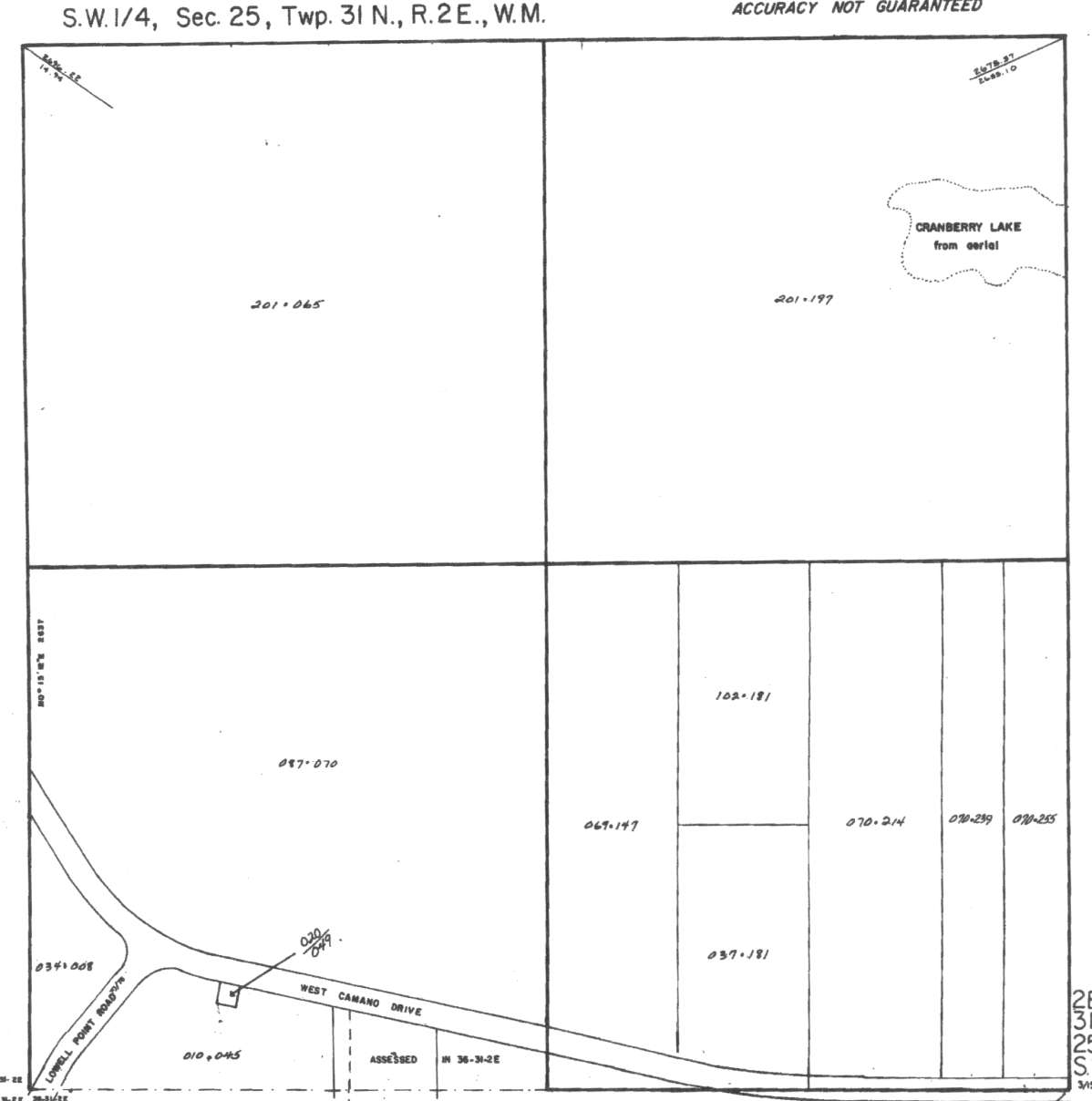
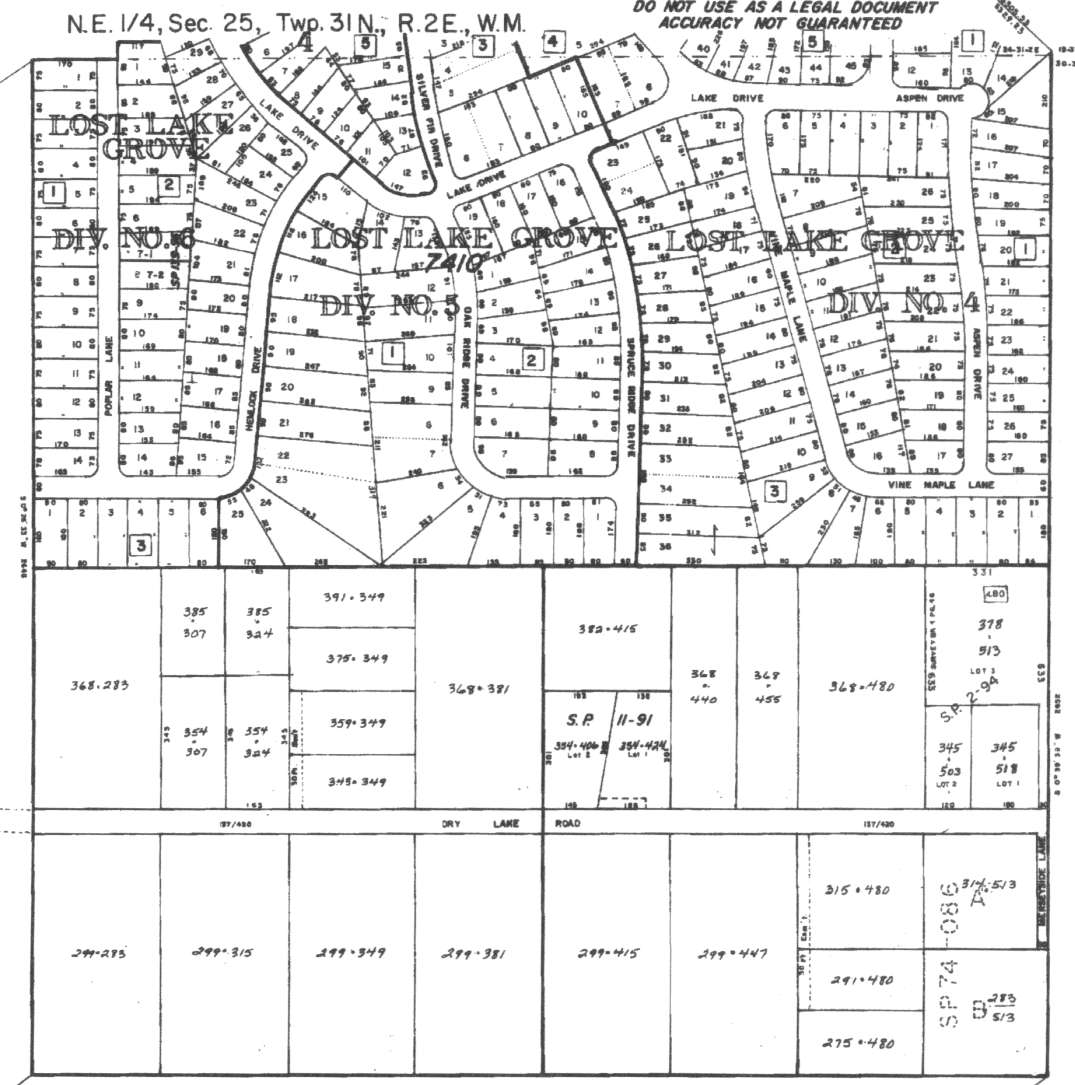
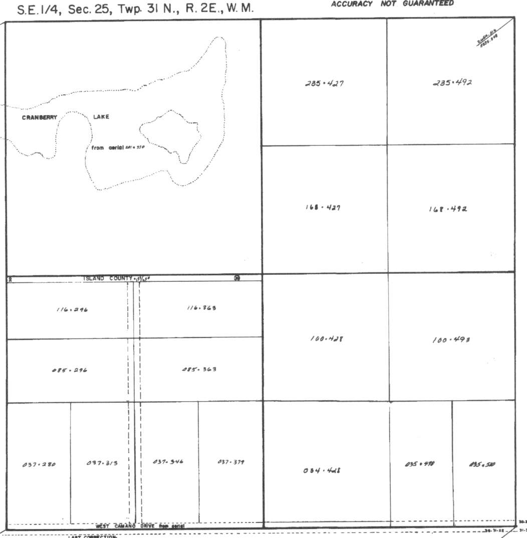
A square system of surveying was ordained by the Continental Congress on May 20, 1785. Within each township (6 miles X 6 miles), are 36 sections. Each section of 640 acres is one mile square (5,280 feet X 5,280 feet). Each quarter section is 160 acres (2,640 feet X 2,640 feet). Most long straight roads and acreage pieces of property have north-south, east-west property lines.
Click on the below Camano section map numbers, to go to a page with Camano Island 2005 assessor data, 1/4 section parcel maps, and aerial photos.
Below are the 26 well reports for this section of Camano, from the December 2004 Washington State Department of Ecology Well log website. Included below is who the well was drilled for, the well depth, and when the well was drilled. At the well log website,
http://apps.ecy.wa.gov/welllog/ more detailed information is available, like the well drillers name, water temperature(sometimes), and soil profile depths.
The below well logs information is from the Washington State Department of Ecology Well log website.
http://apps.ecy.wa.gov/welllog/
 <888>
<888>

GENE FRASER
Public Land Survey: NE, NE, S-25, T-31-N, R-02-E
County: ISLAND, Well Address: 68 W DRY LAKE RD, CAMANO ISLAND, 98292
Well Log ID: 78288 , Notice of Intent Number: 070884
Well Diameter: 6 (inches), Well Depth: 370 (feet)
Well Type: Water, Well Completion Date: 3/17/1993, Well Log Received Date: 5/19/1993
HAROLD IVERSON
Public Land Survey: SE, NE, S-25, T-31-N, R-02-E
County: ISLAND, Well Address: 179 S MERSY SIDED LN, CAMANO ISLAND
Well Log ID: 78790 , Notice of Intent Number: 219212
Well Diameter: 6 (inches), Well Depth: 297 (feet)
Well Type: Water, Well Completion Date: 6/23/1993
MARK YEAST
Public Land Survey: SE, NE, S-25, T-31-N, R-02-E
County: ISLAND, Well Address: 1703 SOUTH SPRUCE RIDGE
Well Log ID: 248140, Well Tag ID: AER673, Notice of Intent Number: W118430
Well Diameter: 6 (inches), Well Depth: 72 (feet)
Well Type: Water, Well Completion Date: 11/29/1999, Well Log Received Date: 1/13/2000
MERIT CONSTRUCTION INC
Public Land Survey: SE, NE, S-25, T-31-N, R-02-E, Tax Parcel Number: R23125-275-4800
County: ISLAND, Well Address: 49 W DRY LAKE RD, CAMANO ISLAND
Well Log ID: 340384, Well Tag ID: ABO819, Notice of Intent Number: W154034
Well Diameter: 6 (inches), Well Depth: 322 (feet)
Well Type: Water, Well Completion Date: 8/25/2002, Well Log Received Date: 9/12/2002
J D OWENBY
Public Land Survey: SW, NE, S-25, T-31-N, R-02-E
County: ISLAND, Well Address: 177 W DRY LAKE RD, CAMANO ISLAND
Well Log ID: 79093 , Notice of Intent Number: W064567
Well Diameter: 36 (inches), Well Depth: 73 (feet)
Well Type: Water, Well Completion Date: 7/24/1996, Well Log Received Date: 7/31/1996
JR. HEIN
Public Land Survey: SW, NE, S-25, T-31-N, R-02-E
County: ISLAND, Well Address: 205 W DRY LAKE RD, CAMANO ISLAND
Well Log ID: 80457 , Notice of Intent Number: 070362
Well Diameter: 6 (inches), Well Depth: 325 (feet)
Well Type: Water, Well Completion Date: 9/17/1990
SCOTT & PEGGY NEHRENZ
Public Land Survey: SW, NE, S-25, T-31-N, R-02-E
County: ISLAND, Well Address: 161 W DRY LAKE RD
Well Log ID: 84363 , Notice of Intent Number: 000685
Well Diameter: 6 (inches), Well Depth: 345 (feet)
Well Type: Water, Well Completion Date: 1/18/1989, Well Log Received Date: 1/30/1989
JAKE PEACEY
Public Land Survey: SW, NE, S-25, T-31-N, R-02-E
County: ISLAND
Well Log ID: 190686, Well Tag ID: AET355, Notice of Intent Number: 116264
Well Diameter: 6 (inches), Well Depth: 312 (feet)
Well Type: Water, Well Completion Date: 7/13/1999, Well Log Received Date: 7/28/1999
DAVID HILBERT
Public Land Survey: SW, NE, S-25, T-31-N, R-02-E
County: ISLAND, Well Address: 140 W DRY LAKE RD
Well Log ID: 314565 , Notice of Intent Number: A051235
Well Diameter: 36 (inches), Well Depth: 14 (feet)
Well Type: Decommissioned, Well Completion Date: 10/24/2001, Well Log Received Date: 11/14/2001
GEORGIA BUTTERTON
Public Land Survey: SW, NE, S-25, T-31-N, R-02-E, Tax Parcel Number: R23125-375-3490
County: ISLAND, Well Address: 148 W DRY LAKE RD, CAMANO ISLAND, 98282
Well Log ID: 330062, Well Tag ID: AFA026, Notice of Intent Number: W147585
Well Diameter: 6 (inches), Well Depth: 278 (feet)
Well Type: Water, Well Completion Date: 3/9/2002, Well Log Received Date: 3/25/2002
SUN MOUNTAIN CONSTRUCTION
Public Land Survey: SW, NE, S-25, T-31-N, R-02-E, Tax Parcel Number: 23125-299-3490
County: ISLAND, Well Address: XXX DRY LAKE RD, CAMANO ISLAND
Well Log ID: 331855, Well Tag ID: ACY399, Notice of Intent Number: W156058
Well Diameter: 6 (inches), Well Depth: 60 (feet)
Well Type: Water, Well Completion Date: 2/28/2002, Well Log Received Date: 4/18/2002
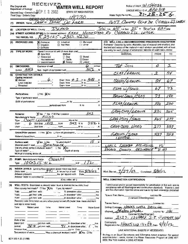
DOHN AND DIANE DELARM
Public Land Survey: SW, NE, S-25, T-31-N, R-02-E, Tax Parcel Number: R23125-235-4270
County: ISLAND, Well Address: XXXX HOMESTEAD RD, CAMANO ISLAND 98282
Well Log ID: 340383, Well Tag ID: ABO818, Notice of Intent Number: W154033
Well Diameter: 6 (inches), Well Depth: 352 (feet)
Well Type: Water, Well Completion Date: 8/8/2002, Well Log Received Date: 9/12/2002
SUN MOUNTAIN CONST
Public Land Survey: SW, NE, S-25, T-31-N, R-02-E
County: ISLAND, Well Address: XXX DRY LAKE RD, CAMANO ISLAND 98282
Well Log ID: 347263, Well Tag ID: AGF414, Notice of Intent Number: W156075
Well Diameter: 6 (inches), Well Depth: 60 (feet)
Well Type: Water, Well Completion Date: 11/5/2002, Well Log Received Date: 11/26/2002
JASON CINDA SHELDON
Public Land Survey: SW, NE, S-25, T-31-N, R-02-E, Tax Parcel Number: R23125-281-3480
County: ISLAND, Well Address: 145 W DRY LAKE RD, CAMANO ISLAND 98292
Well Log ID: 394307, Well Tag ID: ABO993, Notice of Intent Number: W175685
Well Diameter: 6 (inches), Well Depth: 305 (feet)
Well Type: Water, Well Completion Date: 11/24/2004, Well Log Received Date: 12/10/2004
CHARLES & JUDITH NIVER
Public Land Survey: NE, NW, S-25, T-31-N, R-02-E
County: ISLAND, Well Address: 350 HICKORY RD
Well Log ID: 75692 , Notice of Intent Number: 040892
Well Diameter: 6 (inches), Well Depth: 425 (feet)
Well Type: Water, Well Completion Date: 12/18/1991, Well Log Received Date: 1/22/1992
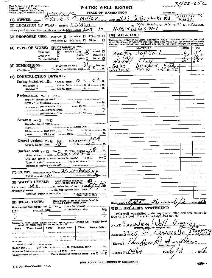
FRANCIS MILLER
Public Land Survey: NE, NW, S-25, T-31-N, R-02-E
County: ISLAND
Well Log ID: 77884
Well Diameter: 36 (inches), Well Depth: 50 (feet)
Well Type: Water, Well Completion Date: 7/2/1976
JOHN LECCESE
Public Land Survey: NE, NW, S-25, T-31-N, R-02-E
County: ISLAND, Well Address: 285 W HICKORY ST, CAMANO ISLAND, 98292
Well Log ID: 80211 , Notice of Intent Number: 070355
Well Diameter: 6 (inches), Well Depth: 266 (feet)
Well Type: Water, Well Completion Date: 9/5/1990, Well Log Received Date: 10/9/1990
SCOTT BATES
Public Land Survey: NW, NW, S-25, T-31-N, R-02-E
County: ISLAND, Well Address: 380 HICKORY ST, CAMANO ISLAND
Well Log ID: 86248, Well Tag ID: AAX621, Notice of Intent Number: W107054
Well Diameter: 6 (inches), Well Depth: 189 (feet)
Well Type: Water, Well Completion Date: 12/10/1998, Well Log Received Date: 12/15/1998
HARDIN
Public Land Survey: SE, NW, S-25, T-31-N, R-02-E
County: ISLAND, Well Address: 140 DRY LAKRD, CAMANO IS
Well Log ID: 120321, Well Tag ID: ABD000, Notice of Intent Number: W075063
Well Diameter: 6 (inches), Well Depth: 340 (feet)
Well Type: Water, Well Completion Date: 1/7/1999, Well Log Received Date: 5/13/1999
EDDIE BLACK
Public Land Survey: NE, SE, S-25, T-31-N, R-02-E, Tax Parcel Number: R23125-168-4920
County: ISLAND, Well Address: W CAMANO DR, CAMANO ISLAND, 98282
Well Log ID: 314560, Well Tag ID: AFJ787, Notice of Intent Number: W118520
Well Diameter: 6 (inches), Well Depth: 338 (feet)
Well Type: Water, Well Completion Date: 9/13/2001, Well Log Received Date: 11/21/2001
DAN SPRATLAND
Public Land Survey: NE, SE, S-25, T-31-N, R-02-E
County: ISLAND, Well Address: 1890 HOMESTEAD LN, CAMANO ISLAND, 98292
Well Log ID: 314566, Well Tag ID: AGK715, Notice of Intent Number: W120965
Well Diameter: 6 (inches), Well Depth: 358 (feet)
Well Type: Water, Well Completion Date: 9/5/2001, Well Log Received Date: 9/10/2001
MICHAEL LOW
Public Land Survey: SE, SE, S-25, T-31-N, R-02-E
County: ISLAND, Well Address: 4 W CAMANO DR
Well Log ID: 81928 , Notice of Intent Number: 074557
Well Diameter: 6 (inches), Well Depth: 309 (feet)
Well Type: Water, Well Completion Date: 5/21/1990
IMRE NEMETH
Public Land Survey: SW, SE, S-25, T-31-N, R-02-E
County: ISLAND, Well Address: 188 W CAMANO DR, CAMANO ISLAND
Well Log ID: 79034
Well Diameter: 6 (inches), Well Depth: 427 (feet)
Well Type: Water, Well Completion Date: 11/13/1992, Well Log Received Date: 12/14/1992
LAWRENCE NEWTON
Public Land Survey: SE, SW, S-25, T-31-N, R-02-E
County: ISLAND, Well Address: MT VIEW RD
Well Log ID: 304115, Well Tag ID: AFJ986, Notice of Intent Number: W128231
Well Diameter: 6 (inches), Well Depth: 380 (feet)
Well Type: Water, Well Completion Date: 1/4/2001, Well Log Received Date: 1/30/2001
WILLIAM WEBB
Public Land Survey: SE, SW, S-25, T-31-N, R-02-E, Tax Parcel Number: R23125-037-3130
County: ISLAND, Well Address: MT VIEW RD
Well Log ID: 332869, Well Tag ID: AGL154, Notice of Intent Number: W147461
Well Diameter: 6 (inches), Well Depth: 401 (feet)
Well Type: Water, Well Completion Date: 4/30/2002, Well Log Received Date: 5/14/2002
FRANK BESANCON
Public Land Survey: SW, SW, S-25, T-31-N, R-02-E
County: ISLAND, Well Address: W CAMANO DR AND LOWELL POINT RD
Well Log ID: 77892
Well Diameter: 6 (inches), Well Depth: 282 (feet)
Well Type: Water , Well Log Received Date: 11/13/1991
JOH AALMO
Public Land Survey: SW, SW, S-25, T-31-N, R-02-E
County: ISLAND
Well Log ID: 80018 , Notice of Intent Number: 070924
Well Diameter: 6 (inches), Well Depth: 260 (feet)
Well Type: Water, Well Completion Date: 5/1/1993, Well Log Received Date: 6/3/1993
wr23125homesteaddelarm2002hanks
wr23125drylakemiller1976snowden