
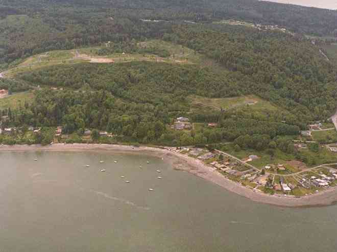
The above September 1997 aerial photo of this section of Camano is from http://www.islandcounty.net/publicworks/digitalphotos/mainmap.htm
The above September 1997 aerial photo of this section of Camano is from
http://www.islandcounty.net/publicworks/digitalphotos/mainmap.htm
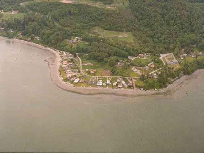
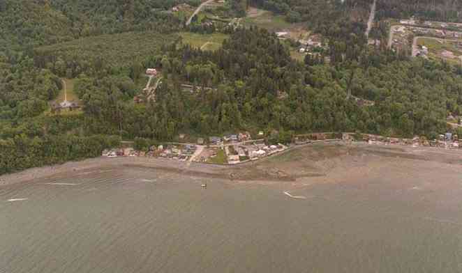
The below 5/8/1993 2:30:00 PM aerial photos are from:
http://apps.ecy.wa.gov/shorephotos


A square system of surveying was ordained by the Continental Congress on May 20, 1785. Within each township (6 miles X 6 miles), are 36 sections. Each section of 640 acres is one mile square (5,280 feet X 5,280 feet). Each quarter section is 160 acres (2,640 feet X 2,640 feet). Most long straight roads and acreage pieces of property have north-south, east-west property lines.
Click on the below Camano section map numbers, to go to a page with Camano Island 2005 assessor data, 1/4 section parcel maps, and aerial photos.
Below are the 42 well reports for this section of Camano, from the December 2004 Washington State Department of Ecology Well log website. Included below is who the well was drilled for, the well depth, and when the well was drilled. At the well log website,
http://apps.ecy.wa.gov/welllog/ more detailed information is available, like the well drillers name, water temperature(sometimes), and soil profile depths.
The below well logs information is from the Washington State Department of Ecology Well log website.
http://apps.ecy.wa.gov/welllog/


 <888>
<888>

1. LARRY DIMMICKĀ - { view PDF
Ā|Ā view TIFF
}
Public Land Survey: SW, NW, S-23, T-32-N, R-02-E, Tax Parcel Number: R23223-297-0500
County: ISLAND, Well Address: EAST OF SCENIC OFF BROKAW, CAMANO ISLAND
Well Log ID: 372873, Well Tag ID: AHP025, Notice of Intent Number: W120935
Well Diameter: 6 (inches), Well Depth: 120 (feet)
Well Type: Water, Well Completion Date: 11/14/2003, Well Log Received Date: 12/30/2003
2. KEVIN LUNDRIGANĀ - { view PDF
Ā|Ā view TIFF
}
Public Land Survey: SE, SW, S-23, T-32-N, R-02-E, Tax Parcel Number: R23223-012-2290
County: ISLAND, Well Address: 660 W SALAL HILL LN, CAMANO ISLAND 98282
Well Log ID: 361385, Well Tag ID: AHG038, Notice of Intent Number: WE01077
Well Diameter: 6 (inches), Well Depth: 397 (feet)
Well Type: Water, Well Completion Date: 5/14/2003, Well Log Received Date: 5/30/2003
3. TODD FARNSWORTHĀ - { view PDF
Ā|Ā view TIFF
}
Public Land Survey: NW, NW, S-23, T-32-N, R-02-E, Tax Parcel Number: (blank)
County: ISLAND, Well Address: 733 BROWN RD, CAMANO ISLAND 98282
Well Log ID: 338687, Well Tag ID: AGF405, Notice of Intent Number: W156065
Well Diameter: 6 (inches), Well Depth: 35 (feet)
Well Type: Water, Well Completion Date: 7/9/2002, Well Log Received Date: 8/21/2002
4. DOUG & MELODY KETTERĀ - { view PDF
Ā|Ā view TIFF
}
Public Land Survey: SE, SW, S-23, T-32-N, R-02-E, Tax Parcel Number: R23223-012-0320
County: ISLAND, Well Address: 833 NW CAMANO DR, CAMANO ISLAND 98282
Well Log ID: 336052, Well Tag ID: AFA029, Notice of Intent Number: W147619
Well Diameter: 6 (inches), Well Depth: 178 (feet)
Well Type: Water, Well Completion Date: 5/11/2002, Well Log Received Date: 6/28/2002
5. SEA AIR LAND DEVELOPMENT COĀ - { view PDF
Ā|Ā view TIFF
}
Public Land Survey: SE, NW, S-23, T-32-N, R-02-E, Tax Parcel Number: (blank)
County: ISLAND, Well Address: 600 BLOCK OF W CAMANO DR, CAMANO ISLAND, 98282
Well Log ID: 305314, Well Tag ID: (blank) , Notice of Intent Number: A002185
Well Diameter: 6 (inches), Well Depth: 146 (feet)
Well Type: Decommissioned, Well Completion Date: 5/23/2001, Well Log Received Date: 6/1/2001
6. KREIG CONSTRUCTIONĀ - { view PDF
Ā|Ā view TIFF
}
Public Land Survey: SE, NW, S-23, T-32-N, R-02-E, Tax Parcel Number: (blank)
County: ISLAND, Well Address: N CAMANO DR AND W CAMANO DR, CAMANO ISLAND
Well Log ID: 305434, Well Tag ID: AGJ497, Notice of Intent Number: R050264
Well Diameter: (blank) , Well Depth: 66 (feet)
Well Type: Resource Protection, Well Completion Date: 5/3/2001, Well Log Received Date: 5/31/2001
7. KREIG CONSTRUCTIONĀ - { view PDF
Ā|Ā view TIFF
}
Public Land Survey: SE, NW, S-23, T-32-N, R-02-E, Tax Parcel Number: (blank)
County: ISLAND, Well Address: N CAMANO DR AND W CAMANO DR, CAMANO ISLAND
Well Log ID: 305435, Well Tag ID: AGH498, Notice of Intent Number: R050264
Well Diameter: (blank) , Well Depth: 25 (feet)
Well Type: Resource Protection, Well Completion Date: 5/3/2001, Well Log Received Date: 5/31/2001
8. ROSE MUSTAINĀ - { view PDF
Ā|Ā view TIFF
}
Public Land Survey: (blank), NE, S-23, T-32-N, R-02-E, Tax Parcel Number: 58355-03-000
County: ISLAND, Well Address: (blank)
Well Log ID: 235477, Well Tag ID: (blank) , Notice of Intent Number: A002178
Well Diameter: 6 (inches), Well Depth: 243 (feet)
Well Type: Decommissioned, Well Completion Date: 9/25/1999, Well Log Received Date: 10/29/1999
9. NILES FOWLERĀ - { view PDF
Ā|Ā view TIFF
}
Public Land Survey: SE, SE, S-23, T-32-N, R-02-E, Tax Parcel Number: (blank)
County: ISLAND, Well Address: 449 W ISLAND VIEW DR
Well Log ID: 74130, Well Tag ID: (blank) , Notice of Intent Number: W064249
Well Diameter: 6 (inches), Well Depth: 398 (feet)
Well Type: Water, Well Completion Date: 1/28/1998, Well Log Received Date: 2/26/1998
10. ROCKY POINT ASSN.Ā - { view PDF
Ā|Ā view TIFF
}
Public Land Survey: NE, SW, S-23, T-32-N, R-02-E, Tax Parcel Number: (blank)
County: ISLAND, Well Address: 904 KAREN ANN, CAMANO ISLAND
Well Log ID: 70098, Well Tag ID: (blank) , Notice of Intent Number: 003035
Well Diameter: 6 (inches), Well Depth: (blank)
Well Type: Water, Well Completion Date: 7/31/1997, Well Log Received Date: (blank)
11. DON BAKERĀ - { view PDF
Ā|Ā view TIFF
}
Public Land Survey: NE, SE, S-23, T-32-N, R-02-E, Tax Parcel Number: (blank)
County: ISLAND, Well Address: (blank)
Well Log ID: 63473, Well Tag ID: (blank) , Notice of Intent Number: 063407
Well Diameter: 6 (inches), Well Depth: 138 (feet)
Well Type: Water, Well Completion Date: 6/13/1997, Well Log Received Date: (blank)
12. DON BALSERĀ - { view PDF
Ā|Ā view TIFF
}
Public Land Survey: NE, SE, S-23, T-32-N, R-02-E, Tax Parcel Number: (blank)
County: ISLAND, Well Address: (blank)
Well Log ID: 63474, Well Tag ID: (blank) , Notice of Intent Number: 063407
Well Diameter: 6 (inches), Well Depth: 35 (feet)
Well Type: Water, Well Completion Date: 3/7/1997, Well Log Received Date: (blank)
13. GORDON SMITHĀ - { view PDF
Ā|Ā view TIFF
}
Public Land Survey: NE, SW, S-23, T-32-N, R-02-E, Tax Parcel Number: (blank)
County: ISLAND, Well Address: 910 NW CAMANO DR, CAMANO ISLAND, 98292
Well Log ID: 64855, Well Tag ID: (blank) , Notice of Intent Number: W054354
Well Diameter: 6 (inches), Well Depth: 157 (feet)
Well Type: Water, Well Completion Date: 5/3/1996, Well Log Received Date: (blank)
14. LEE HARMONĀ - { view PDF
Ā|Ā view TIFF
}
Public Land Survey: SW, NE, S-23, T-32-N, R-02-E, Tax Parcel Number: (blank)
County: ISLAND, Well Address: BRENTWOOD
Well Log ID: 67159, Well Tag ID: (blank) , Notice of Intent Number: W065619
Well Diameter: 6 (inches), Well Depth: 217 (feet)
Well Type: Water, Well Completion Date: 4/25/1996, Well Log Received Date: 5/6/1996
15. MAPLE GROVE WATES ASSN.Ā - { view PDF
Ā|Ā view TIFF
}
Public Land Survey: SE, NW, S-23, T-32-N, R-02-E, Tax Parcel Number: (blank)
County: ISLAND, Well Address: 628 W N CAMANO DR, CAMANO ISLAND, 98292
Well Log ID: 67560, Well Tag ID: (blank) , Notice of Intent Number: W054340
Well Diameter: 6 (inches), Well Depth: 68 (feet)
Well Type: Water, Well Completion Date: 2/15/1996, Well Log Received Date: 3/4/1996
16. Maple Grove Water AssocĀ - { view PDF
Ā|Ā view TIFF
}
Public Land Survey: SE, NW, S-23, T-32-N, R-02-E, Tax Parcel Number: (blank)
County: ISLAND, Well Address: 628 W N Camano Dr
Well Log ID: 67559, Well Tag ID: AGA753, Notice of Intent Number: W054349
Well Diameter: 6 (inches), Well Depth: 320 (feet)
Well Type: Water, Well Completion Date: 2/12/1996, Well Log Received Date: 2/21/1996
17. WILLIAM AKINĀ - { view PDF
Ā|Ā view TIFF
}
Public Land Survey: NE, SW, S-23, T-32-N, R-02-E, Tax Parcel Number: (blank)
County: ISLAND, Well Address: 666 W LORRIEN LN, CAMANO ISLAND
Well Log ID: 71753, Well Tag ID: (blank) , Notice of Intent Number: W054351
Well Diameter: 6 (inches), Well Depth: 122 (feet)
Well Type: Water, Well Completion Date: 12/20/1995, Well Log Received Date: 6/28/1996
18. FLOYD & JENNIFER DEWITTĀ - { view PDF
Ā|Ā view TIFF
}
Public Land Survey: NE, SW, S-23, T-32-N, R-02-E, Tax Parcel Number: (blank)
County: ISLAND, Well Address: 665 W LORRIEN LN, CAMANO ISLAND
Well Log ID: 64209, Well Tag ID: (blank) , Notice of Intent Number: W010548
Well Diameter: 6 (inches), Well Depth: 144 (feet)
Well Type: Water, Well Completion Date: 6/9/1995, Well Log Received Date: 6/19/1995
19. HOWARD ROBBĀ - { view PDF
Ā|Ā view TIFF
}
Public Land Survey: NW, NW, S-23, T-32-N, R-02-E, Tax Parcel Number: (blank)
County: ISLAND, Well Address: MAPLE GROVE HEIGHTS
Well Log ID: 65293, Well Tag ID: (blank) , Notice of Intent Number: (blank)
Well Diameter: 6 (inches), Well Depth: 172 (feet)
Well Type: Water, Well Completion Date: 10/6/1993, Well Log Received Date: 11/12/1993
20. HARVEY SMITHĀ - { view PDF
Ā|Ā view TIFF
}
Public Land Survey: SE, SE, S-23, T-32-N, R-02-E, Tax Parcel Number: (blank)
County: ISLAND, Well Address: 449 ISLAND VIEW DR CT
Well Log ID: 65135, Well Tag ID: (blank) , Notice of Intent Number: (blank)
Well Diameter: 6 (inches), Well Depth: 362 (feet)
Well Type: Water, Well Completion Date: 7/1/1992, Well Log Received Date: 9/28/1992
21. JOHN BANELĀ - { view PDF
Ā|Ā view TIFF
}
Public Land Survey: SE, SW, S-23, T-32-N, R-02-E, Tax Parcel Number: (blank)
County: ISLAND, Well Address: 860 N WEST CAMANO DR, CAMANO ISLAND
Well Log ID: 66210, Well Tag ID: (blank) , Notice of Intent Number: (blank)
Well Diameter: 6 (inches), Well Depth: 145 (feet)
Well Type: Water, Well Completion Date: 10/21/1991, Well Log Received Date: 11/7/1991
22. MARK CLEARYĀ - { view PDF
Ā|Ā view TIFF
}
Public Land Survey: SE, NW, S-23, T-32-N, R-02-E, Tax Parcel Number: (blank)
County: ISLAND, Well Address: 628 W N CAMANO DR
Well Log ID: 379379, Well Tag ID: AGA754, Notice of Intent Number: (blank)
Well Diameter: 6 (inches), Well Depth: 66 (feet)
Well Type: Water, Well Completion Date: 8/28/1990, Well Log Received Date: 10/9/1990
23. KEN WATKINSĀ - { view PDF
Ā|Ā view TIFF
}
Public Land Survey: SW, SW, S-23, T-32-N, R-02-E, Tax Parcel Number: (blank)
County: ISLAND, Well Address: 851 NW CAMANO DR, CAMANO ISLAND
Well Log ID: 66777, Well Tag ID: (blank) , Notice of Intent Number: 070342
Well Diameter: 6 (inches), Well Depth: 50 (feet)
Well Type: Water, Well Completion Date: 6/11/1990, Well Log Received Date: (blank)
24. ROCKT PT HOTS WATER ASSN.Ā - { view PDF
Ā|Ā view TIFF
}
Public Land Survey: NW, SE, S-23, T-32-N, R-02-E, Tax Parcel Number: (blank)
County: ISLAND, Well Address: 904 KAREN ANN DR
Well Log ID: 70096, Well Tag ID: (blank) , Notice of Intent Number: (blank)
Well Diameter: 8 (inches), Well Depth: 620 (feet)
Well Type: Water, Well Completion Date: 3/27/1990, Well Log Received Date: 6/4/1990
25. AL OLSONĀ - { view PDF
Ā|Ā view TIFF
}
Public Land Survey: NE, NW, S-23, T-32-N, R-02-E, Tax Parcel Number: (blank)
County: ISLAND, Well Address: (blank)
Well Log ID: 61048, Well Tag ID: (blank) , Notice of Intent Number: (blank)
Well Diameter: 6 (inches), Well Depth: 370 (feet)
Well Type: Water, Well Completion Date: 9/27/1989, Well Log Received Date: 10/12/1989
26. RICHAR DIMMICKĀ - { view PDF
Ā|Ā view TIFF
}
Public Land Survey: SW, NW, S-23, T-32-N, R-02-E, Tax Parcel Number: (blank)
County: ISLAND, Well Address: BROKAW AND FLINSTONE, CAMANO ISLAND
Well Log ID: 69663, Well Tag ID: (blank) , Notice of Intent Number: 023275
Well Diameter: 6 (inches), Well Depth: 154 (feet)
Well Type: Water, Well Completion Date: 9/22/1989, Well Log Received Date: 10/10/1989
27. RAY HEMNEYĀ - { view PDF
Ā|Ā view TIFF
}
Public Land Survey: SW, SE, S-23, T-32-N, R-02-E, Tax Parcel Number: (blank)
County: ISLAND, Well Address: (blank)
Well Log ID: 69549, Well Tag ID: (blank) , Notice of Intent Number: (blank)
Well Diameter: 6 (inches), Well Depth: 412 (feet)
Well Type: Water, Well Completion Date: 3/15/1985, Well Log Received Date: 8/1/1985
28. SCENIC BEACH WATER ASSNĀ - { view PDF
Ā|Ā view TIFF
}
Public Land Survey: (blank), (blank), S-23, T-32-N, R-02-E, Tax Parcel Number: (blank)
County: ISLAND, Well Address: 1060 SCENIC AVE
Well Log ID: 376490, Well Tag ID: AGA740, Notice of Intent Number: (blank)
Well Diameter: 6 (inches), Well Depth: 126 (feet)
Well Type: Water, Well Completion Date: 11/24/1981, Well Log Received Date: (blank)
29. E.G. CAMPBELLĀ - { view PDF
Ā|Ā view TIFF
}
Public Land Survey: NE, SW, S-23, T-32-N, R-02-E, Tax Parcel Number: (blank)
County: ISLAND, Well Address: (blank)
Well Log ID: 63832, Well Tag ID: (blank) , Notice of Intent Number: (blank)
Well Diameter: 6 (inches), Well Depth: 158 (feet)
Well Type: Water, Well Completion Date: 3/15/1981, Well Log Received Date: (blank)
30. HENRY EDWIN SHAW Ā - { view PDF
Ā|Ā view TIFF
}
Public Land Survey: NE, SW, S-23, T-32-N, R-02-E, Tax Parcel Number: (blank)
County: ISLAND, Well Address: (blank)
Well Log ID: 351170, Well Tag ID: (blank) , Notice of Intent Number: (blank)
Well Diameter: 8 (inches), Well Depth: 340 (feet)
Well Type: Water, Well Completion Date: 7/15/1968, Well Log Received Date: (blank)
31. GILBERTSON LAND COĀ - { view PDF
Ā|Ā view TIFF
}
Public Land Survey: NW, SW, S-23, T-32-N, R-02-E, Tax Parcel Number: (blank)
County: ISLAND, Well Address: (blank)
Well Log ID: 351172, Well Tag ID: (blank) , Notice of Intent Number: (blank)
Well Diameter: 8 (inches), Well Depth: 188 (feet)
Well Type: Water, Well Completion Date: 12/3/1962, Well Log Received Date: (blank)
32. ACALADI WATER ASSNĀ - { view PDF
Ā|Ā view TIFF
}
Public Land Survey: NW, NE, S-23, T-32-N, R-02-E, Tax Parcel Number: (blank)
County: ISLAND, Well Address: (blank)
Well Log ID: 351166, Well Tag ID: (blank) , Notice of Intent Number: (blank)
Well Diameter: 6 (inches), Well Depth: 280 (feet)
Well Type: Water, Well Completion Date: 7/10/1962, Well Log Received Date: (blank)
33. C W BROKAWĀ - { view PDF
Ā|Ā view TIFF
}
Public Land Survey: NE, SW, S-23, T-32-N, R-02-E, Tax Parcel Number: (blank)
County: ISLAND, Well Address: (blank)
Well Log ID: 351169, Well Tag ID: (blank) , Notice of Intent Number: (blank)
Well Diameter: (blank) , Well Depth: (blank)
Well Type: Water, Well Completion Date: 7/15/1940, Well Log Received Date: (blank)
34. BJORN LUNDBERGĀ - { view PDF
Ā|Ā view TIFF
}
Public Land Survey: NE, SW, S-23, T-32-N, R-02-E, Tax Parcel Number: (blank)
County: ISLAND, Well Address: 643 W N CAMANO DR, CAMANO ISLAND
Well Log ID: 61731, Well Tag ID: (blank) , Notice of Intent Number: W010601
Well Diameter: 6 (inches), Well Depth: 100 (feet)
Well Type: Water, Well Completion Date: (blank) , Well Log Received Date: 10/19/1993
35. MARK CRAEFORDĀ - { view PDF
Ā|Ā view TIFF
}
Public Land Survey: SW, SW, S-23, T-32-N, R-02-E, Tax Parcel Number: (blank)
County: ISLAND, Well Address: 890 NW CAMANO DR, CAMANO ISLAND
Well Log ID: 67610, Well Tag ID: (blank) , Notice of Intent Number: W073071
Well Diameter: 6 (inches), Well Depth: (blank)
Well Type: Water, Well Completion Date: (blank) , Well Log Received Date: 3/5/1998
36. LEE HARMONĀ - { view PDF
Ā|Ā view TIFF
}
Public Land Survey: SW, NE, S-23, T-32-N, R-02-E, Tax Parcel Number: (blank)
County: ISLAND, Well Address: (blank)
Well Log ID: 278472, Well Tag ID: (blank) , Notice of Intent Number: (blank)
Well Diameter: 6 (inches), Well Depth: 377 (feet)
Well Type: Water, Well Completion Date: (blank) , Well Log Received Date: (blank)
37. LEE HARMONĀ - { view PDF
Ā|Ā view TIFF
}
Public Land Survey: SW, NE, S-23, T-32-N, R-02-E, Tax Parcel Number: (blank)
County: ISLAND, Well Address: (blank)
Well Log ID: 278473, Well Tag ID: (blank) , Notice of Intent Number: (blank)
Well Diameter: 6 (inches), Well Depth: 377 (feet)
Well Type: Water, Well Completion Date: (blank) , Well Log Received Date: (blank)
38. ROGER NELSONĀ - { view PDF
Ā|Ā view TIFF
}
Public Land Survey: SE, NW, S-23, T-32-N, R-02-E, Tax Parcel Number: (blank)
County: ISLAND, Well Address: (blank)
Well Log ID: 278717, Well Tag ID: (blank) , Notice of Intent Number: (blank)
Well Diameter: 6 (inches), Well Depth: 205 (feet)
Well Type: Water, Well Completion Date: (blank) , Well Log Received Date: (blank)
39. ROGER NELSONĀ - { view PDF
Ā|Ā view TIFF
}
Public Land Survey: SE, NW, S-23, T-32-N, R-02-E, Tax Parcel Number: (blank)
County: ISLAND, Well Address: (blank)
Well Log ID: 278718, Well Tag ID: (blank) , Notice of Intent Number: (blank)
Well Diameter: 6 (inches), Well Depth: 205 (feet)
Well Type: Water, Well Completion Date: (blank) , Well Log Received Date: (blank)
40. SCENIC BEACH WATER COĀ - { view PDF
Ā|Ā view TIFF
}
Public Land Survey: SW, NW, S-23, T-32-N, R-02-E, Tax Parcel Number: (blank)
County: ISLAND, Well Address: 1060 N SCENIC AVE
Well Log ID: 351167, Well Tag ID: AGA747, Notice of Intent Number: (blank)
Well Diameter: 8 (inches), Well Depth: 115 (feet)
Well Type: Water, Well Completion Date: (blank) , Well Log Received Date: (blank)
41. HOWARD ROBBĀ - { view PDF
Ā|Ā view TIFF
}
Public Land Survey: SW, NE, S-23, T-32-N, R-02-E, Tax Parcel Number: (blank)
County: ISLAND, Well Address: (blank)
Well Log ID: 351168, Well Tag ID: (blank) , Notice of Intent Number: (blank)
Well Diameter: 36 (inches), Well Depth: 50 (feet)
Well Type: Water, Well Completion Date: (blank) , Well Log Received Date: (blank)
42. ROCKY POINT COMMUNITY CLUBĀ - { view PDF
Ā|Ā view TIFF
}
Public Land Survey: SE, NW, S-23, T-32-N, R-02-E, Tax Parcel Number: (blank)
County: ISLAND, Well Address: (blank)
Well Log ID: 351171, Well Tag ID: (blank) , Notice of Intent Number: (blank)
Well Diameter: 8 (inches), Well Depth: 325 (feet)
Well Type: Water, Well Completion Date: (blank) , Well Log Received Date: (blank)
wr23223brokaw1913-40brokaw

wr23223maplegrove1996stein

wr23223scenicdimmick2003arlington
