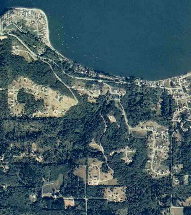
The above September 1997 aerial photo of this section of Camano is from http://www.islandcounty.net/publicworks/digitalphotos/mainmap.htm
The above September 1997 aerial photo of this section of Camano is from
http://www.islandcounty.net/publicworks/digitalphotos/mainmap.htm
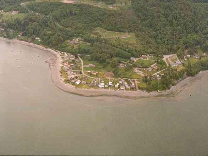
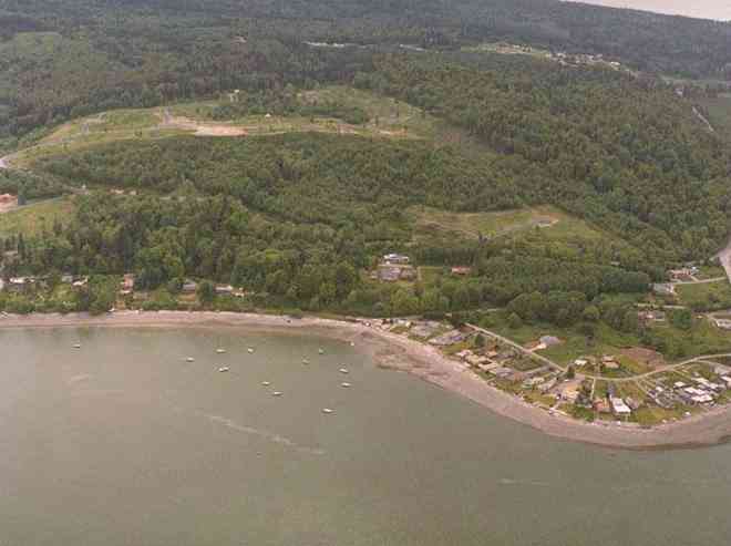
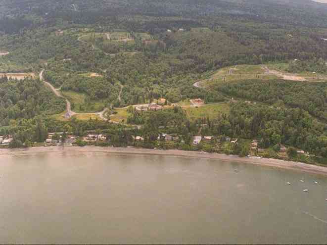
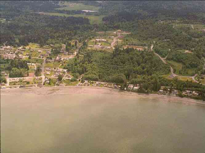
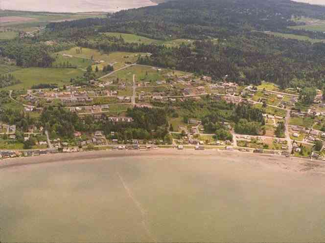
The below 5/8/1993 2:30:00 PM aerial photos are from:
http://apps.ecy.wa.gov/shorephotos
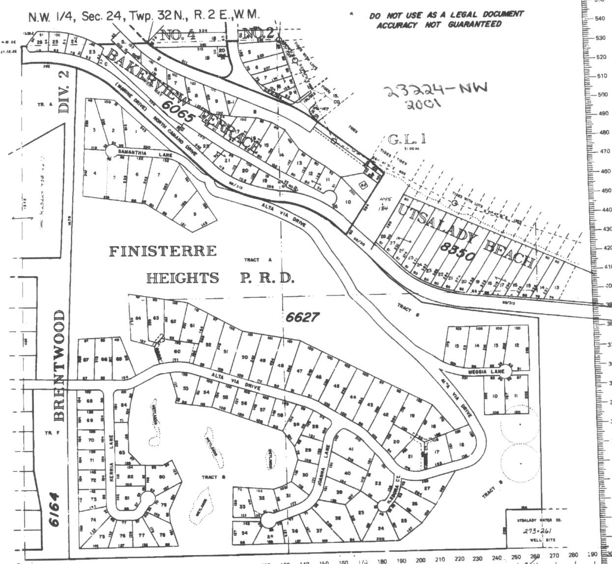
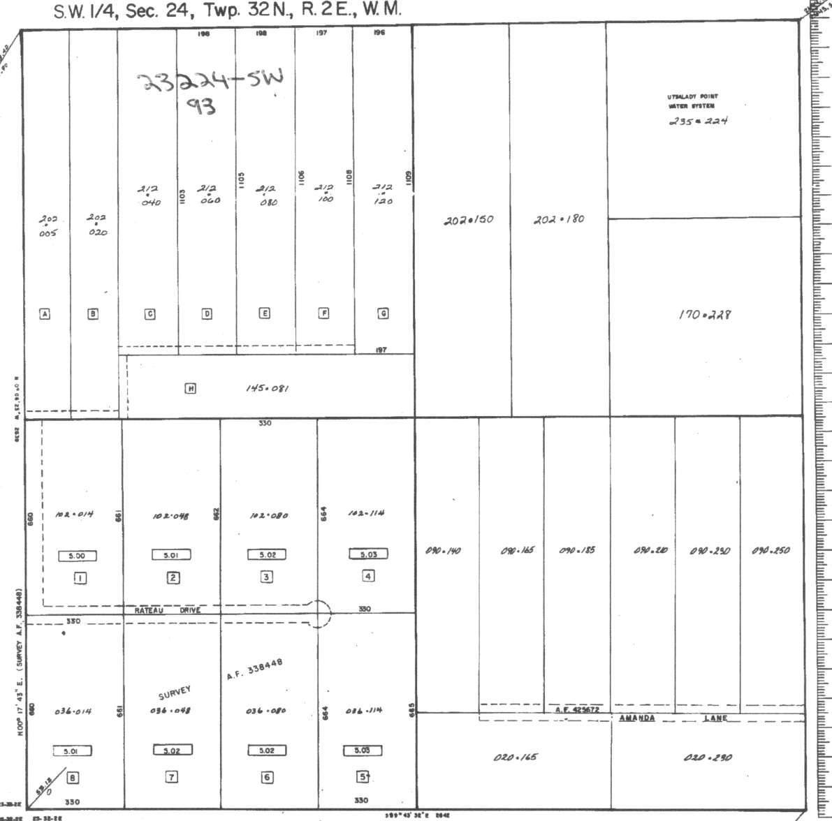
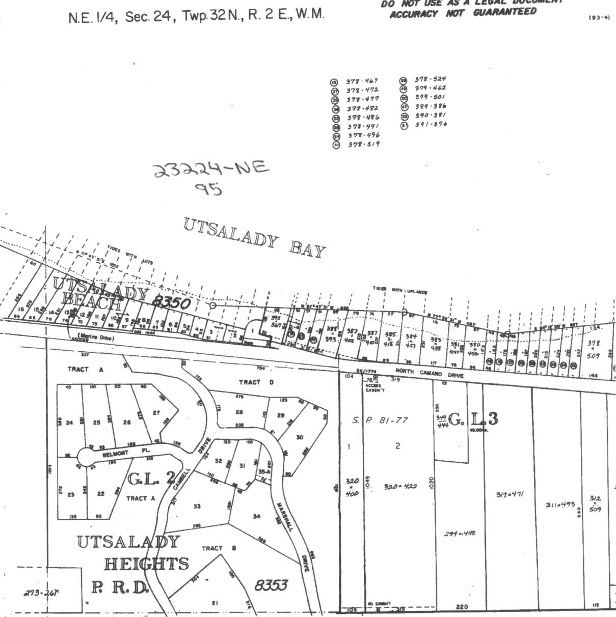
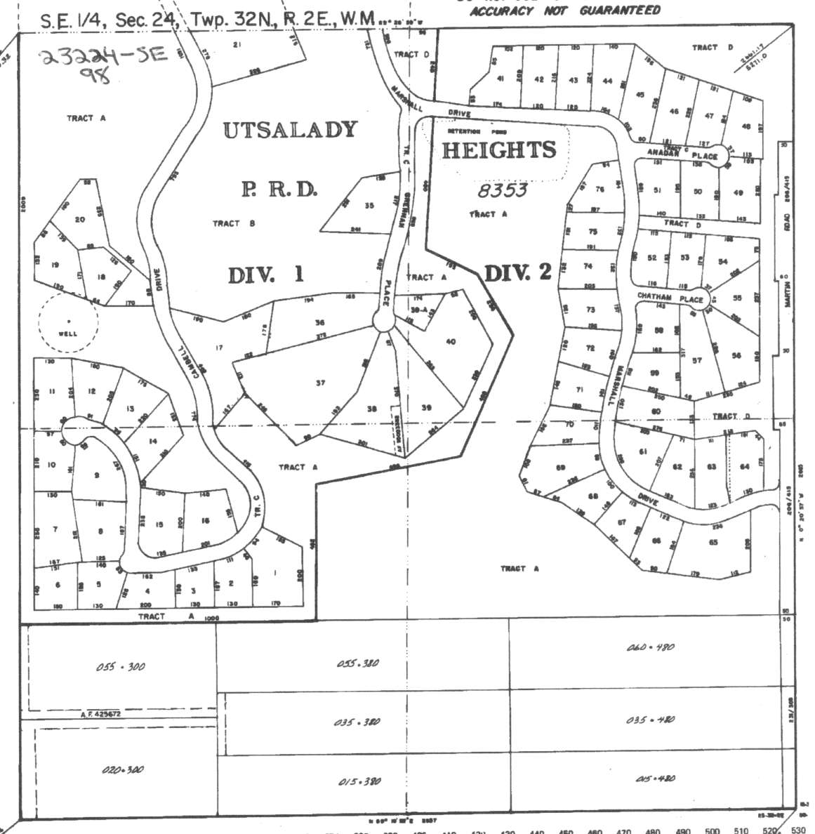
A square system of surveying was ordained by the Continental Congress on May 20, 1785. Within each township (6 miles X 6 miles), are 36 sections. Each section of 640 acres is one mile square (5,280 feet X 5,280 feet). Each quarter section is 160 acres (2,640 feet X 2,640 feet). Most long straight roads and acreage pieces of property have north-south, east-west property lines.
Click on the below Camano section map numbers, to go to a page with Camano Island 2005 assessor data, 1/4 section parcel maps, and aerial photos.
Below are the 24 well reports for this section of Camano, from the December 2004 Washington State Department of Ecology Well log website. Included below is who the well was drilled for, the well depth, and when the well was drilled. At the well log website,
http://apps.ecy.wa.gov/welllog/ more detailed information is available, like the well drillers name, water temperature(sometimes), and soil profile depths.
The below well logs information is from the Washington State Department of Ecology Well log website.
http://apps.ecy.wa.gov/welllog/
 <888>
<888>

1. PAUL GILBERTSONĀ - { view PDF
Ā|Ā view TIFF
}
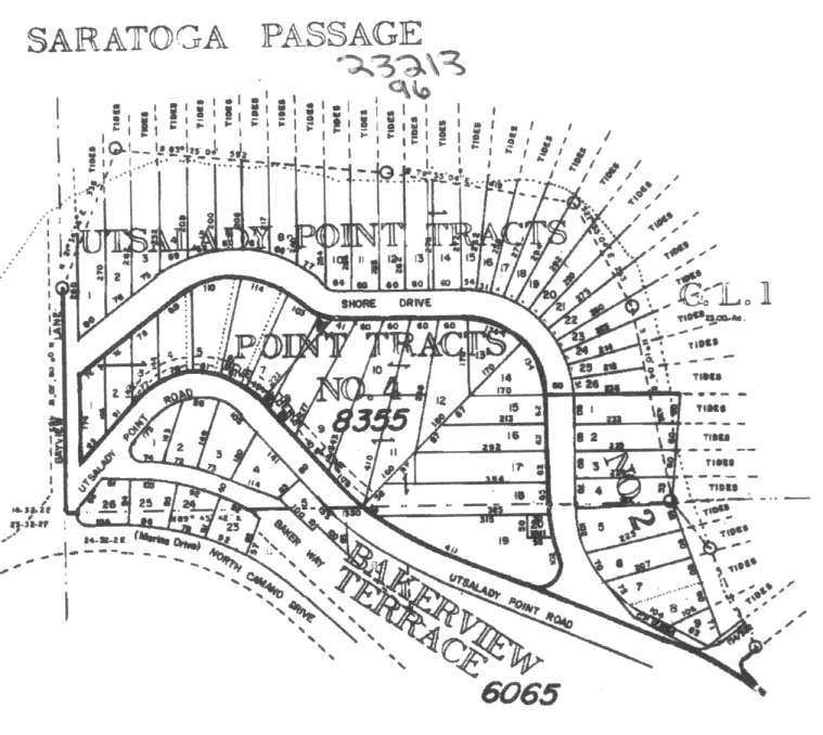
Public Land Survey: SE, SW, S-24, T-32-N, R-02-E, Tax Parcel Number: R232240202300
County: ISLAND, Well Address: 227 AMANDA LN, CAMANO ISLAND
Well Log ID: 386481, Well Tag ID: AHP039, Notice of Intent Number: W168883
Well Diameter: 6 (inches), Well Depth: 412 (feet)
Well Type: Water, Well Completion Date: 7/19/2004, Well Log Received Date: 9/7/2004
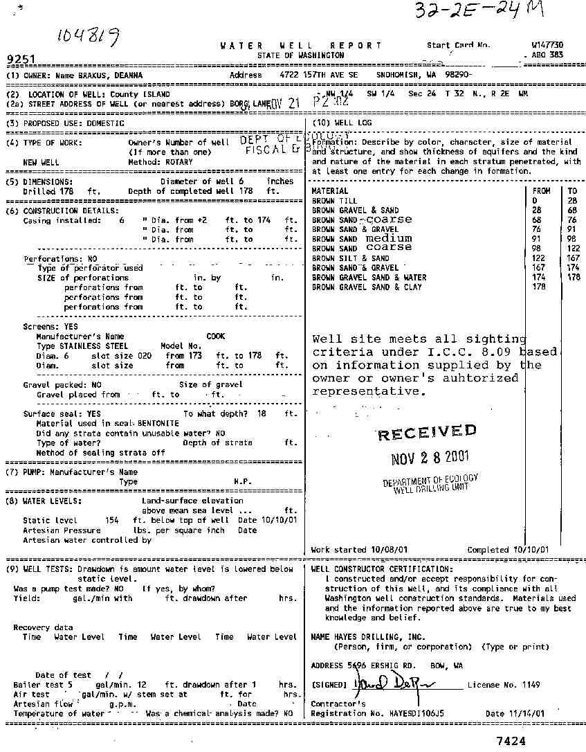
2. DEANNA BRAKUSĀ - { view PDF
Ā|Ā view TIFF
}
Public Land Survey: NW, SW, S-24, T-32-N, R-02-E, Tax Parcel Number: 223-224-202-1500
County: ISLAND, Well Address: BORG LN, CAMANO ISLAND
Well Log ID: 314585, Well Tag ID: ABO383, Notice of Intent Number: W147730
Well Diameter: 6 (inches), Well Depth: 178 (feet)
Well Type: Water, Well Completion Date: 10/10/2001, Well Log Received Date: 11/29/2001
3. JIM STARKĀ - { view PDF
Ā|Ā view TIFF
}
Public Land Survey: NW, SW, S-24, T-32-N, R-02-E, Tax Parcel Number: (blank)
County: ISLAND, Well Address: BORG LN, CAMANO ISLAND, 98292
Well Log ID: 305315, Well Tag ID: AFT001, Notice of Intent Number: W118155
Well Diameter: 6 (inches), Well Depth: 355 (feet)
Well Type: Water, Well Completion Date: 3/2/2001, Well Log Received Date: 4/3/2001
4. GORDON BAKKEĀ - { view PDF
Ā|Ā view TIFF
}
Public Land Survey: NW, SW, S-24, T-32-N, R-02-E, Tax Parcel Number: (blank)
County: ISLAND, Well Address: 342 BORG LN, CAMANO ISLAND
Well Log ID: 190071, Well Tag ID: ABD015, Notice of Intent Number: W120052
Well Diameter: 6 (inches), Well Depth: 364 (feet)
Well Type: Water, Well Completion Date: 8/5/1999, Well Log Received Date: 8/16/1999
5. JANE MAVOR - EVROCRAFTĀ - { view PDF
Ā|Ā view TIFF
}
Public Land Survey: SE, NW, S-24, T-32-N, R-02-E, Tax Parcel Number: (blank)
County: ISLAND, Well Address: 250 W FAY LN, CAMANO ISLAND, 98292
Well Log ID: 190356, Well Tag ID: AEF890, Notice of Intent Number: W094550
Well Diameter: 6 (inches), Well Depth: 142 (feet)
Well Type: Water, Well Completion Date: 6/11/1999, Well Log Received Date: 6/22/1999
6. GEORGE WESTĀ - { view PDF
Ā|Ā view TIFF
}
Public Land Survey: NE, NE, S-24, T-32-N, R-02-E, Tax Parcel Number: (blank)
County: ISLAND, Well Address: 159 E UTSALADY RD, CAMANO ISLAND
Well Log ID: 64695, Well Tag ID: (blank) , Notice of Intent Number: A003095
Well Diameter: 36 (inches), Well Depth: 8 (feet)
Well Type: Decommissioned, Well Completion Date: 1/14/1999, Well Log Received Date: 2/10/1999
7. CARSTON ANDERSONĀ - { view PDF
Ā|Ā view TIFF
}
Public Land Survey: NW, SW, S-24, T-32-N, R-02-E, Tax Parcel Number: (blank)
County: ISLAND, Well Address: RATEAU & BORG LANE, CAMANO ISLAND
Well Log ID: 73751, Well Tag ID: ACY703, Notice of Intent Number: W064391
Well Diameter: 6 (inches), Well Depth: 358 (feet)
Well Type: Water, Well Completion Date: 11/13/1997, Well Log Received Date: 11/17/1997
8. JIM CLINEĀ - { view PDF
Ā|Ā view TIFF
}
Public Land Survey: NW, SW, S-24, T-32-N, R-02-E, Tax Parcel Number: (blank)
County: ISLAND, Well Address: 324TH BORGLAND, CAMANO ISLAND
Well Log ID: 73577, Well Tag ID: ACN227, Notice of Intent Number: W077558
Well Diameter: 6 (inches), Well Depth: (blank)
Well Type: Water, Well Completion Date: 4/24/1997, Well Log Received Date: 4/29/1997
9. MARY HARDERĀ - { view PDF
Ā|Ā view TIFF
}
Public Land Survey: SW, NW, S-24, T-32-N, R-02-E, Tax Parcel Number: (blank)
County: ISLAND, Well Address: 83 E N CAMANO DR, CAMANO ISLAND, 98292
Well Log ID: 67755, Well Tag ID: (blank) , Notice of Intent Number: (blank)
Well Diameter: 6 (inches), Well Depth: 22 (feet)
Well Type: Water, Well Completion Date: 5/27/1996, Well Log Received Date: 6/3/1996
10. CRAIG GINDRAUXĀ - { view PDF
Ā|Ā view TIFF
}
Public Land Survey: SE, SW, S-24, T-32-N, R-02-E, Tax Parcel Number: (blank)
County: ISLAND, Well Address: AMANDA LN, CAMANO ISLAND
Well Log ID: 62673, Well Tag ID: (blank) , Notice of Intent Number: W054347
Well Diameter: 6 (inches), Well Depth: 382 (feet)
Well Type: Water, Well Completion Date: 12/11/1995, Well Log Received Date: 6/28/1996
11. DAVID MARITZĀ - { view PDF
Ā|Ā view TIFF
}
Public Land Survey: SW, SE, S-24, T-32-N, R-02-E, Tax Parcel Number: (blank)
County: ISLAND, Well Address: 31 W N CAMANO DR,CAMANO ISLAND, 98292
Well Log ID: 63162, Well Tag ID: (blank) , Notice of Intent Number: W043587
Well Diameter: 6 (inches), Well Depth: 180 (feet)
Well Type: Water, Well Completion Date: 5/27/1995, Well Log Received Date: 6/19/1995
12. MARK KEENEĀ - { view PDF
Ā|Ā view TIFF
}
Public Land Survey: SW, SE, S-24, T-32-N, R-02-E, Tax Parcel Number: (blank)
County: ISLAND, Well Address: 37 W N CAMANO DR, CAMANO ISLAND
Well Log ID: 67632, Well Tag ID: (blank) , Notice of Intent Number: W043585
Well Diameter: 6 (inches), Well Depth: 180 (feet)
Well Type: Water, Well Completion Date: 3/16/1995, Well Log Received Date: (blank)
13. E.W. ELLINGSENĀ - { view PDF
Ā|Ā view TIFF
}
Public Land Survey: SE, SW, S-24, T-32-N, R-02-E, Tax Parcel Number: (blank)
County: ISLAND, Well Address: AMANDA LN, CAMANO ISLAND, 98292
Well Log ID: 63834, Well Tag ID: (blank) , Notice of Intent Number: 040885
Well Diameter: 6 (inches), Well Depth: 262 (feet)
Well Type: Water, Well Completion Date: 10/4/1991, Well Log Received Date: 10/15/1991
14. BOB GIBBONSĀ - { view PDF
Ā|Ā view TIFF
}
Public Land Survey: SW, NW, S-24, T-32-N, R-02-E, Tax Parcel Number: (blank)
County: ISLAND, Well Address: 50125 246TH ST NE
Well Log ID: 373851, Well Tag ID: AGA754, Notice of Intent Number: (blank)
Well Diameter: 6 (inches), Well Depth: 119 (feet)
Well Type: Water, Well Completion Date: 9/17/1991, Well Log Received Date: 12/20/1991
15. BOB GIBBONSĀ - { view PDF
Ā|Ā view TIFF
}
Public Land Survey: SW, NW, S-24, T-32-N, R-02-E, Tax Parcel Number: (blank)
County: ISLAND, Well Address: (blank)
Well Log ID: 61792, Well Tag ID: (blank) , Notice of Intent Number: 071991
Well Diameter: 6 (inches), Well Depth: 353 (feet)
Well Type: Water, Well Completion Date: 9/6/1991, Well Log Received Date: (blank)
16. TERRY CONOVERĀ - { view PDF
Ā|Ā view TIFF
}
Public Land Survey: SE, SW, S-24, T-32-N, R-02-E, Tax Parcel Number: (blank)
County: ISLAND, Well Address: 200 W AND AMANDA LN, CAMANO ISLAND, 98292
Well Log ID: 71015, Well Tag ID: (blank) , Notice of Intent Number: 040818
Well Diameter: 6 (inches), Well Depth: 410 (feet)
Well Type: Water, Well Completion Date: 3/13/1991, Well Log Received Date: 3/25/1991
17. RICHARD SLATERĀ - { view PDF
Ā|Ā view TIFF
}
Public Land Survey: SE, SE, S-24, T-32-N, R-02-E, Tax Parcel Number: (blank)
County: ISLAND, Well Address: 200 W AND W HIGHLAND DR
Well Log ID: 69798, Well Tag ID: (blank) , Notice of Intent Number: 070341
Well Diameter: 6 (inches), Well Depth: 366 (feet)
Well Type: Water, Well Completion Date: 10/30/1990, Well Log Received Date: (blank)
18. NICK SEEGERTĀ - { view PDF
Ā|Ā view TIFF
}
Public Land Survey: NW, SE, S-24, T-32-N, R-02-E, Tax Parcel Number: (blank)
County: ISLAND, Well Address: CAMPBELL DR
Well Log ID: 68783, Well Tag ID: AGA758, Notice of Intent Number: (blank)
Well Diameter: 6 (inches), Well Depth: 296 (feet)
Well Type: Water, Well Completion Date: 5/25/1988, Well Log Received Date: (blank)
19. CLARENCE RATEAUĀ - { view PDF
Ā|Ā view TIFF
}
Public Land Survey: SW, SW, S-24, T-32-N, R-02-E, Tax Parcel Number: (blank)
County: ISLAND, Well Address: (blank)
Well Log ID: 62544, Well Tag ID: (blank) , Notice of Intent Number: (blank)
Well Diameter: (blank) , Well Depth: (blank)
Well Type: Water, Well Completion Date: 6/14/1979, Well Log Received Date: (blank)
20. VIRGINIA ISAACSONĀ - { view PDF
Ā|Ā view TIFF
}
Public Land Survey: NW, NW, S-24, T-32-N, R-02-E, Tax Parcel Number: (blank)
County: ISLAND, Well Address: (blank)
Well Log ID: 71456, Well Tag ID: (blank) , Notice of Intent Number: (blank)
Well Diameter: 36 (inches), Well Depth: 19 (feet)
Well Type: Water, Well Completion Date: 6/11/1976, Well Log Received Date: (blank)
21. UTSALADY POINT WATER DIST. INC.Ā - { view PDF
Ā|Ā view TIFF
}
Public Land Survey: NE, SW, S-24, T-32-N, R-02-E, Tax Parcel Number: (blank)
County: ISLAND, Well Address: BELMONT AND CAMPBELL
Well Log ID: 71357, Well Tag ID: AGA775, Notice of Intent Number: (blank)
Well Diameter: 6 (inches), Well Depth: 190 (feet)
Well Type: Water, Well Completion Date: 8/15/1972, Well Log Received Date: (blank)
22. OSCAR L CHINBERGĀ - { view PDF
Ā|Ā view TIFF
}
Public Land Survey: NE, NW, S-24, T-32-N, R-02-E, Tax Parcel Number: (blank)
County: ISLAND, Well Address: (blank)
Well Log ID: 351174, Well Tag ID: (blank) , Notice of Intent Number: (blank)
Well Diameter: 6 (inches), Well Depth: 107 (feet)
Well Type: Water, Well Completion Date: 5/23/1969, Well Log Received Date: (blank)
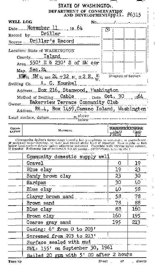
23. BAKERVIEW TERRACE COMMUNITY CLUBĀ - { view PDF
Ā|Ā view TIFF
}
Public Land Survey: NW, NW, S-24, T-32-N, R-02-E, Tax Parcel Number: (blank)
County: ISLAND, Well Address: (blank)
Well Log ID: 351175, Well Tag ID: (blank) , Notice of Intent Number: (blank)
Well Diameter: 6 (inches), Well Depth: 213 (feet)
Well Type: Water, Well Completion Date: 10/30/1964, Well Log Received Date: (blank)
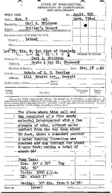
24. ESTATE OF R R BRADLEYĀ - { view PDF
Ā|Ā view TIFF
}
Public Land Survey: NW, NE, S-24, T-32-N, R-02-E, Tax Parcel Number: (blank)
County: ISLAND, Well Address: (blank)
Well Log ID: 351173, Well Tag ID: (blank) , Notice of Intent Number: (blank)
Well Diameter: 30 (inches), Well Depth: 56 (feet)
Well Type: Water, Well Completion Date: 1/18/1946, Well Log Received Date: (blank)
wr23224bakerview1964kounkel
wr23224utsaladybradley1946erickson
wr23224borgbrakus2001hayes