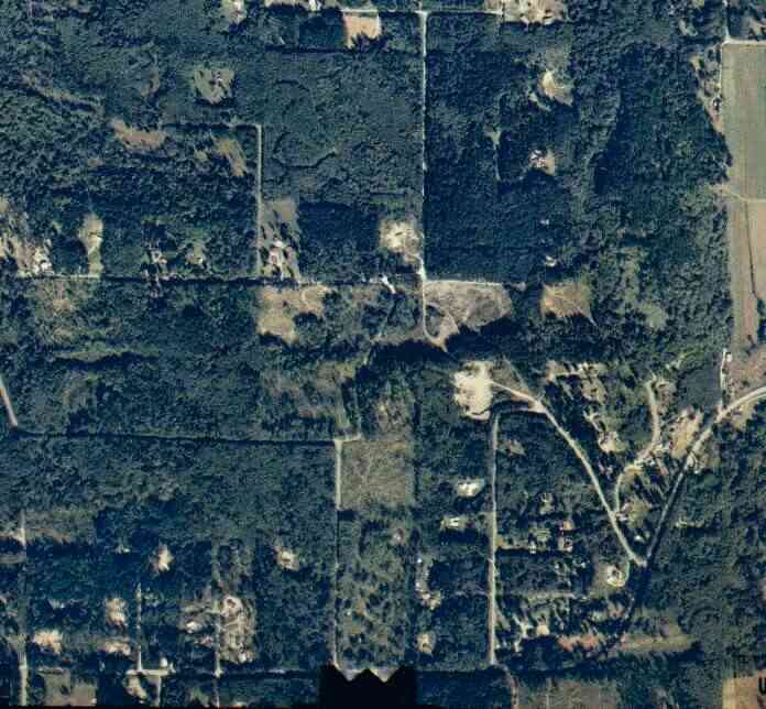
The above September 1997 aerial photo of this section of Camano is from http://www.islandcounty.net/publicworks/digitalphotos/mainmap.htm
The above September 1997 aerial photo of this section of Camano is from
http://www.islandcounty.net/publicworks/digitalphotos/mainmap.htm
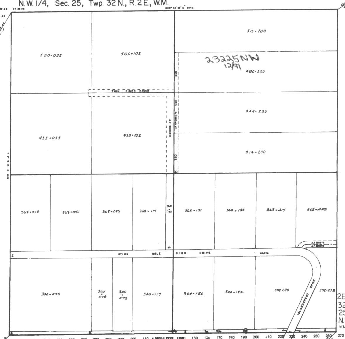
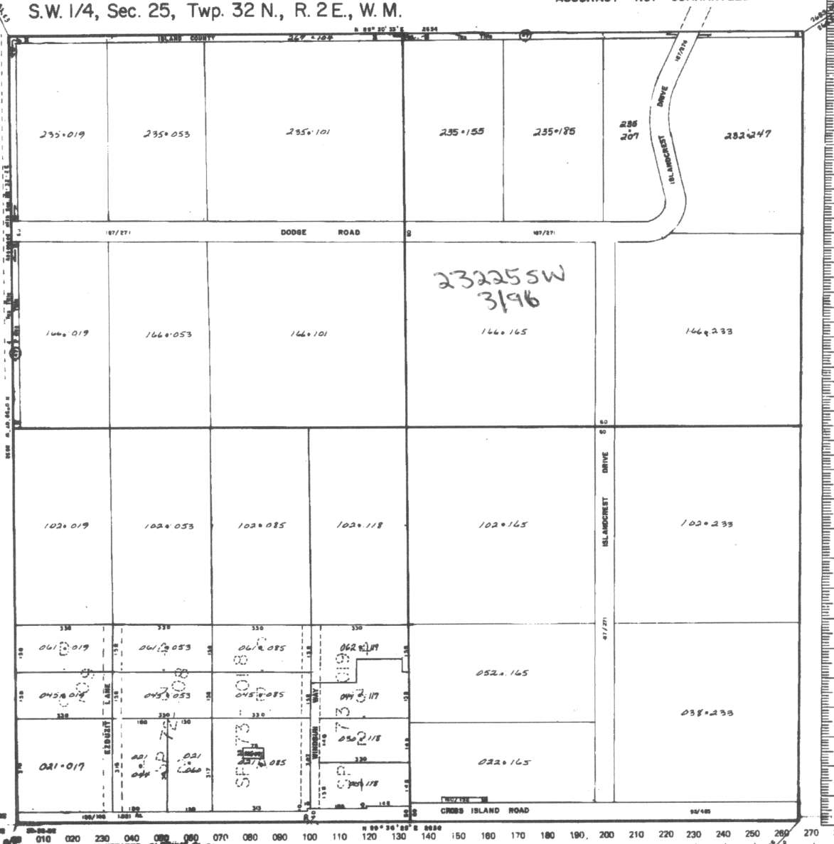
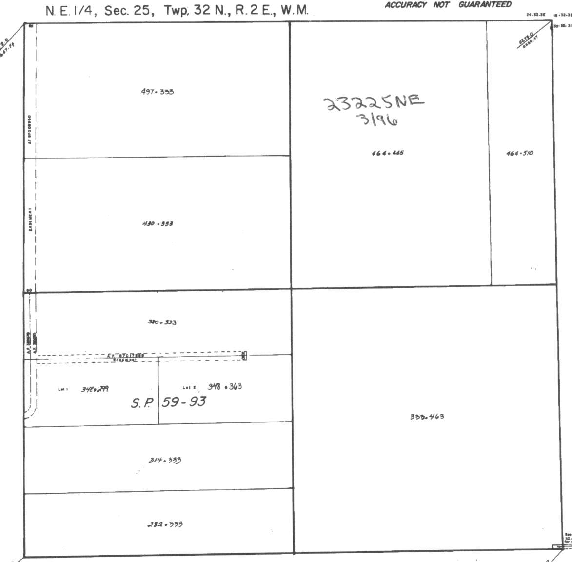
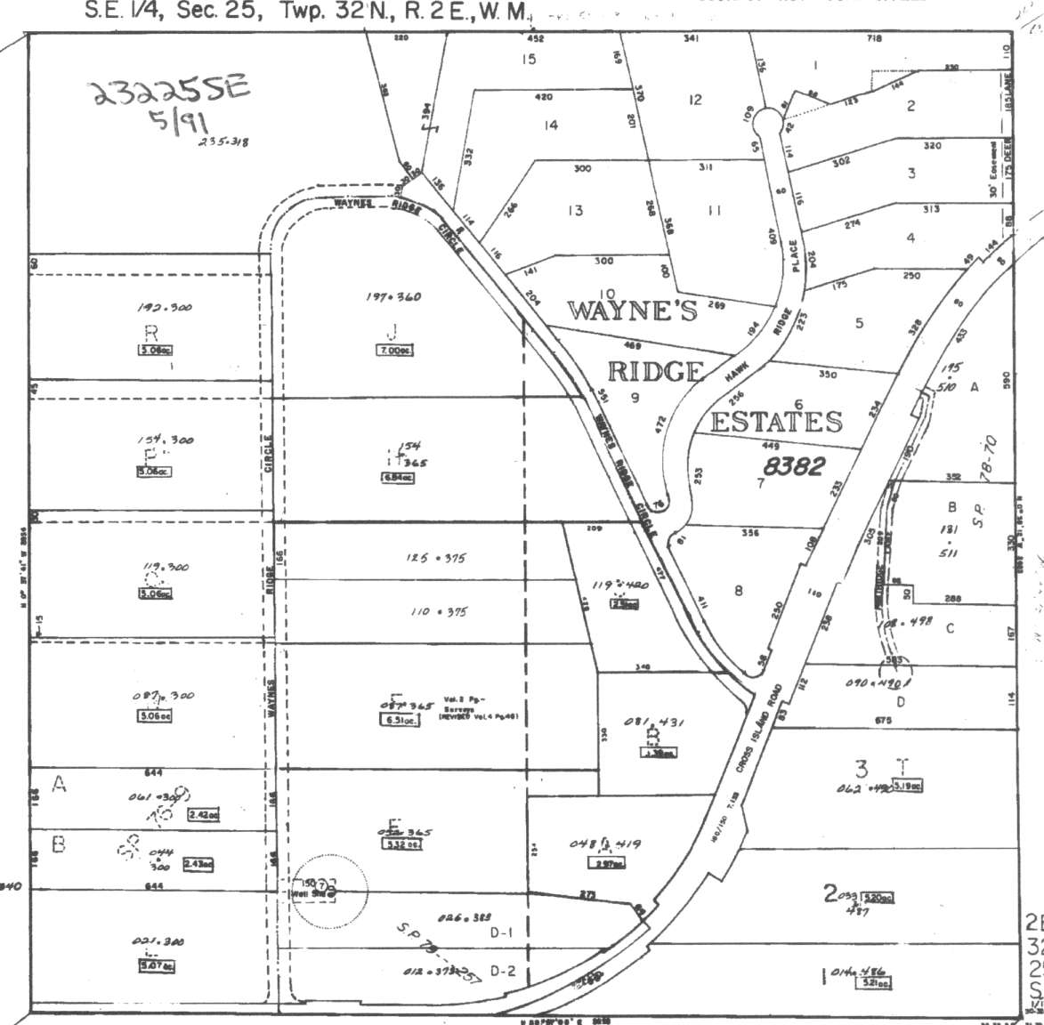
A square system of surveying was ordained by the Continental Congress on May 20, 1785. Within each township (6 miles X 6 miles), are 36 sections. Each section of 640 acres is one mile square (5,280 feet X 5,280 feet). Each quarter section is 160 acres (2,640 feet X 2,640 feet). Most long straight roads and acreage pieces of property have north-south, east-west property lines.
Click on the below Camano section map numbers, to go to a page with Camano Island 2005 assessor data, 1/4 section parcel maps, and aerial photos.
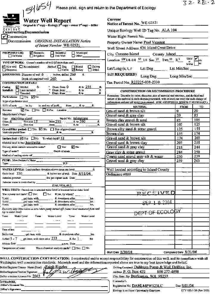
Below are the 29 well reports for this section of Camano, from the December 2004 Washington State Department of Ecology Well log website. Included below is who the well was drilled for, the well depth, and when the well was drilled. At the well log website,
http://apps.ecy.wa.gov/welllog/ more detailed information is available, like the well drillers name, water temperature(sometimes), and soil profile depths.
The below well logs information is from the Washington State Department of Ecology Well log website.
http://apps.ecy.wa.gov/welllog/
 <888>
<888>

1. PAUL VANSANTĀ - { view PDF
Ā|Ā view TIFF
}
Public Land Survey: SW, SE, S-25, T-32-N, R-02-E, Tax Parcel Number: R23225-038-2330
County: ISLAND, Well Address: 434 ISLAND CREST DRIVE, CAMANO ISLAND 98282
Well Log ID: 386150, Well Tag ID: ALA104, Notice of Intent Number: WE02521
Well Diameter: 6 (inches), Well Depth: 260 (feet)
Well Type: Water, Well Completion Date: 8/31/2004, Well Log Received Date: 9/10/2004
2. STEVE MERKLEYĀ - { view PDF
Ā|Ā view TIFF
}
Public Land Survey: SE, SW, S-25, T-32-N, R-02-E, Tax Parcel Number: (blank)
County: ISLAND, Well Address: 460 ISLAND CREST DR, CAMANO ISLAND
Well Log ID: 383202, Well Tag ID: AHT426, Notice of Intent Number: W177635
Well Diameter: 6 (inches), Well Depth: 337 (feet)
Well Type: Water, Well Completion Date: 6/23/2004, Well Log Received Date: 7/14/2004
3. BART KLETTĀ - { view PDF
Ā|Ā view TIFF
}
Public Land Survey: NE, NW, S-25, T-32-N, R-02-E, Tax Parcel Number: R23225-448-2000
County: ISLAND, Well Address: XXX TWIN PINES DR, CAMANO ISLAND 98282
Well Log ID: 369257, Well Tag ID: ABO952, Notice of Intent Number: W153735
Well Diameter: 6 (inches), Well Depth: 282 (feet)
Well Type: Water, Well Completion Date: 8/29/2003, Well Log Received Date: 9/29/2003
4. HENRY R KLETTĀ - { view PDF
Ā|Ā view TIFF
}
Public Land Survey: NE, NW, S-25, T-32-N, R-02-E, Tax Parcel Number: R23225-480-200
County: ISLAND, Well Address: XXX TWIN PINES DR, CAMANO ISLAND, 98282
Well Log ID: 364438, Well Tag ID: ABO944, Notice of Intent Number: W153722
Well Diameter: 6 (inches), Well Depth: 291 (feet)
Well Type: Water, Well Completion Date: 6/5/2003, Well Log Received Date: 7/2/2003
5. RICHARD AINSWORTHĀ - { view PDF
Ā|Ā view TIFF
}
Public Land Survey: SW, SW, S-25, T-32-N, R-02-E, Tax Parcel Number: (blank)
County: ISLAND, Well Address: WIND SUN WY, CAMANO ISLAND
Well Log ID: 347294, Well Tag ID: (blank) , Notice of Intent Number: A053829
Well Diameter: 8 (inches), Well Depth: 7 (feet)
Well Type: Decommissioned, Well Completion Date: 11/19/2002, Well Log Received Date: 11/26/2002
6. RICHARD AINSWORTHĀ - { view PDF
Ā|Ā view TIFF
}
Public Land Survey: SW, SW, S-25, T-32-N, R-02-E, Tax Parcel Number: (blank)
County: ISLAND, Well Address: WIND SUN WY, CAMANO ISLAND
Well Log ID: 347295, Well Tag ID: (blank) , Notice of Intent Number: S014777
Well Diameter: 8 (inches), Well Depth: 7 (feet)
Well Type: Resource Protection, Well Completion Date: 11/19/2002, Well Log Received Date: 11/26/2002
7. DICK KOCKĀ - { view PDF
Ā|Ā view TIFF
}
Public Land Survey: NE, SW, S-25, T-32-N, R-02-E, Tax Parcel Number: (blank)
County: ISLAND, Well Address: XX ISLAND CREST DRIVE
Well Log ID: 343846, Well Tag ID: AGO270, Notice of Intent Number: WE00688
Well Diameter: 6 (inches), Well Depth: 134 (feet)
Well Type: Water, Well Completion Date: 10/15/2002, Well Log Received Date: 10/23/2002
8. WINDSUN WY WATER ASSOCĀ - { view PDF
Ā|Ā view TIFF
}
Public Land Survey: SW, SW, S-25, T-32-N, R-02-E, Tax Parcel Number: E1N91-1920156
County: ISLAND, Well Address: 430 N WINDSUN WY, CAMANO ISLAND
Well Log ID: 331857, Well Tag ID: AGL149, Notice of Intent Number: W147457
Well Diameter: 6 (inches), Well Depth: 585 (feet)
Well Type: Water, Well Completion Date: 3/22/2002, Well Log Received Date: 4/11/2002
9. DICK KOCKĀ - { view PDF
Ā|Ā view TIFF
}
Public Land Survey: NE, SW, S-25, T-32-N, R-02-E, Tax Parcel Number: (blank)
County: ISLAND, Well Address: XX ISLAND CREST DR. CAMANO IS.
Well Log ID: 325795, Well Tag ID: AGO932, Notice of Intent Number: W147581
Well Diameter: 6 (inches), Well Depth: 275 (feet)
Well Type: Water, Well Completion Date: 11/30/2001, Well Log Received Date: 2/22/2002
10. GEORGE JOHNSONĀ - { view PDF
Ā|Ā view TIFF
}
Public Land Survey: NE, SW, S-25, T-32-N, R-02-E, Tax Parcel Number: (blank)
County: ISLAND, Well Address: 270 DODGE RD, CAMANO ISLAND
Well Log ID: 305346, Well Tag ID: AGH013, Notice of Intent Number: W118196
Well Diameter: 6 (inches), Well Depth: 324 (feet)
Well Type: Water, Well Completion Date: 5/30/2001, Well Log Received Date: 6/27/2001
11. RICHARD KOCHĀ - { view PDF
Ā|Ā view TIFF
}
Public Land Survey: NW, SW, S-25, T-32-N, R-02-E, Tax Parcel Number: (blank)
County: ISLAND, Well Address: XXXX DODGE RD CAMANO IS
Well Log ID: 304123, Well Tag ID: AFP981, Notice of Intent Number: W127824
Well Diameter: 6 (inches), Well Depth: 62 (feet)
Well Type: Water, Well Completion Date: 2/23/2001, Well Log Received Date: 3/12/2001
12. KURT ASPLUNDĀ - { view PDF
Ā|Ā view TIFF
}
Public Land Survey: SW, NE, S-25, T-32-N, R-02-E, Tax Parcel Number: (blank)
County: ISLAND, Well Address: 119 CHIPMUNK PL, CAMANO ISLAND, 98292
Well Log ID: 304124, Well Tag ID: AEF945, Notice of Intent Number: W099648
Well Diameter: 6 (inches), Well Depth: 324 (feet)
Well Type: Water, Well Completion Date: 1/12/2001, Well Log Received Date: 1/16/2001
13. NORTHLAND CABLEĀ - { view PDF
Ā|Ā view TIFF
}
Public Land Survey: NW, NW, S-25, T-32-N, R-02-E, Tax Parcel Number: (blank)
County: ISLAND, Well Address: 398 W CROSS ISLAND RD, CAMANO ISLAND, 98292
Well Log ID: 304122, Well Tag ID: (blank) , Notice of Intent Number: S000193
Well Diameter: 4.25 (inches), Well Depth: 12 (feet)
Well Type: Resource Protection, Well Completion Date: 11/3/2000, Well Log Received Date: 11/16/2000
14. BRAD & CATHY NELSONĀ - { view PDF
Ā|Ā view TIFF
}
Public Land Survey: SW, SW, S-25, T-32-N, R-02-E, Tax Parcel Number: 23-225-102-0856
County: ISLAND, Well Address: WIND-SON WAY
Well Log ID: 248114, Well Tag ID: AKF251, Notice of Intent Number: W098323
Well Diameter: 6 (inches), Well Depth: 102 (feet)
Well Type: Water, Well Completion Date: 5/15/2000, Well Log Received Date: 6/3/2000
15. NORM HARRINGTONĀ - { view PDF
Ā|Ā view TIFF
}
Public Land Survey: SW, NE, S-25, T-32-N, R-02-E, Tax Parcel Number: (blank)
County: ISLAND, Well Address: 119 CHIPMUNK PL
Well Log ID: 68819, Well Tag ID: (blank) , Notice of Intent Number: W108258
Well Diameter: 6 (inches), Well Depth: 289 (feet)
Well Type: Water, Well Completion Date: 2/17/1999, Well Log Received Date: 3/2/1999
16. BOB YOUNGĀ - { view PDF
Ā|Ā view TIFF
}
Public Land Survey: SW, NW, S-25, T-32-N, R-02-E, Tax Parcel Number: (blank)
County: ISLAND, Well Address: MILE HIGH DR, CAMANO ISLAND
Well Log ID: 73913, Well Tag ID: AEB994, Notice of Intent Number: W093328
Well Diameter: 6 (inches), Well Depth: 242 (feet)
Well Type: Water, Well Completion Date: 10/22/1998, Well Log Received Date: 10/28/1998
17. N. WIND SUN WAY WATER GROUPĀ - { view PDF
Ā|Ā view TIFF
}
Public Land Survey: NW, NE, S-25, T-32-N, R-02-E, Tax Parcel Number: (blank)
County: ISLAND, Well Address: 430 WIND SUN WAY, CAMANO IS
Well Log ID: 122217, Well Tag ID: ACQ051, Notice of Intent Number: W077746
Well Diameter: 6 (inches), Well Depth: 287 (feet)
Well Type: Water, Well Completion Date: 9/27/1998, Well Log Received Date: 10/21/1998
18. PAUL KATHANĀ - { view PDF
Ā|Ā view TIFF
}
Public Land Survey: NW, NE, S-25, T-32-N, R-02-E, Tax Parcel Number: (blank)
County: ISLAND, Well Address: (blank)
Well Log ID: 117481, Well Tag ID: (blank) , Notice of Intent Number: 094194
Well Diameter: 6 (inches), Well Depth: 235 (feet)
Well Type: Water, Well Completion Date: 3/20/1998, Well Log Received Date: 4/22/1999
19. BOB NICKELSON & RICK WALKERĀ - { view PDF
Ā|Ā view TIFF
}
Public Land Survey: SE, NW, S-25, T-32-N, R-02-E, Tax Parcel Number: (blank)
County: ISLAND, Well Address: HIGH DR AND AMANDA LN
Well Log ID: 61857, Well Tag ID: (blank) , Notice of Intent Number: W073055
Well Diameter: 6 (inches), Well Depth: 350 (feet)
Well Type: Water, Well Completion Date: 10/22/1996, Well Log Received Date: 11/1/1996
20. G.A. POWELL CONSTR.Ā - { view PDF
Ā|Ā view TIFF
}
Public Land Survey: SW, SW, S-25, T-32-N, R-02-E, Tax Parcel Number: (blank)
County: ISLAND, Well Address: EZDUZIT LN, CAMANO ISLAND, 98292
Well Log ID: 64419, Well Tag ID: (blank) , Notice of Intent Number: W054339
Well Diameter: 6 (inches), Well Depth: (blank)
Well Type: Water, Well Completion Date: 3/5/1996, Well Log Received Date: 3/13/1996
21. RICK REKDALĀ - { view PDF
Ā|Ā view TIFF
}
Public Land Survey: SW, NE, S-25, T-32-N, R-02-E, Tax Parcel Number: (blank)
County: ISLAND, Well Address: ISLAND CREST
Well Log ID: 69860, Well Tag ID: (blank) , Notice of Intent Number: W065584
Well Diameter: 6 (inches), Well Depth: 312 (feet)
Well Type: Water, Well Completion Date: 12/6/1995, Well Log Received Date: 12/22/1995
22. DELL JOHNSONĀ - { view PDF
Ā|Ā view TIFF
}
Public Land Survey: SW, SW, S-25, T-32-N, R-02-E, Tax Parcel Number: (blank)
County: ISLAND, Well Address: WIND SUN WY, CAMANO ISLAND, 98252
Well Log ID: 63268, Well Tag ID: (blank) , Notice of Intent Number: (blank)
Well Diameter: 6 (inches), Well Depth: 286 (feet)
Well Type: Water, Well Completion Date: 10/19/1995, Well Log Received Date: (blank)
23. DAVID MURDOCKĀ - { view PDF
Ā|Ā view TIFF
}
Public Land Survey: SW, NW, S-25, T-32-N, R-02-E, Tax Parcel Number: (blank)
County: ISLAND, Well Address: MILE HIGH DR, CAMANO ISLAND, 98292
Well Log ID: 63168, Well Tag ID: (blank) , Notice of Intent Number: W043583
Well Diameter: 6 (inches), Well Depth: 420 (feet)
Well Type: Water, Well Completion Date: 1/23/1995, Well Log Received Date: 2/2/1995
24. HARRY IMMERĀ - { view PDF
Ā|Ā view TIFF
}
Public Land Survey: SW, SW, S-25, T-32-N, R-02-E, Tax Parcel Number: (blank)
County: ISLAND, Well Address: 431 N WIND SUN WY, CAMANO ISLAND, 98292
Well Log ID: 65107, Well Tag ID: (blank) , Notice of Intent Number: W043559
Well Diameter: 6 (inches), Well Depth: 140 (feet)
Well Type: Water, Well Completion Date: 7/12/1994, Well Log Received Date: 8/23/1994
25. DARRYL WILLIAMSĀ - { view PDF
Ā|Ā view TIFF
}
Public Land Survey: SW, NE, S-25, T-32-N, R-02-E, Tax Parcel Number: (blank)
County: SNOHOMISH, Well Address: (blank)
Well Log ID: 76424, Well Tag ID: (blank) , Notice of Intent Number: (blank)
Well Diameter: 6 (inches), Well Depth: 320 (feet)
Well Type: Water, Well Completion Date: 9/20/1985, Well Log Received Date: (blank)
26. DEPT. OF ECOLGYĀ - { view PDF
Ā|Ā view TIFF
}
Public Land Survey: SW, NE, S-25, T-32-N, R-02-E, Tax Parcel Number: (blank)
County: ISLAND, Well Address: (blank)
Well Log ID: 63347, Well Tag ID: (blank) , Notice of Intent Number: (blank)
Well Diameter: 8 (inches), Well Depth: 1000 (feet)
Well Type: Water, Well Completion Date: 11/17/1983, Well Log Received Date: 3/19/1984
27. WASHINGTON STATE DEPARTMENT OF ECOLOGYĀ - { view PDF
Ā|Ā view TIFF
}
Public Land Survey: NW, SE, S-25, T-32-N, R-02-E, Tax Parcel Number: (blank)
County: ISLAND, Well Address: WAYNES RIDGE CIRCLE, CAMANO ISLAND
Well Log ID: 336259, Well Tag ID: AAE884, Notice of Intent Number: (blank)
Well Diameter: 8 (inches), Well Depth: 1000 (feet)
Well Type: Water, Well Completion Date: 11/17/1983, Well Log Received Date: (blank)
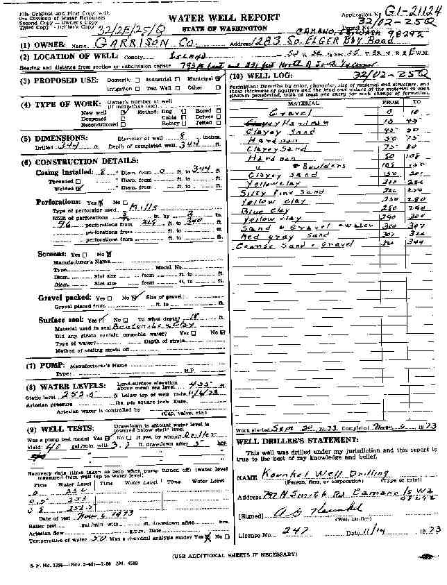
28. GARRISON CO.Ā - { view PDF
Ā|Ā view TIFF
}
Public Land Survey: SW, SE, S-25, T-32-N, R-02-E, Tax Parcel Number: (blank)
County: ISLAND, Well Address: (blank)
Well Log ID: 64441, Well Tag ID: AGA732, Notice of Intent Number: (blank)
Well Diameter: 8 (inches), Well Depth: 344 (feet)
Well Type: Water, Well Completion Date: 11/6/1973, Well Log Received Date: (blank)
29. SOUTH HILL WATER COOPĀ - { view PDF
Ā|Ā view TIFF
}
Public Land Survey: SE, NE, S-25, T-32-N, R-02-E, Tax Parcel Number: (blank)
County: ISLAND, Well Address: (blank)
Well Log ID: 351176, Well Tag ID: (blank) , Notice of Intent Number: (blank)
Well Diameter: (blank) , Well Depth: (blank)
Well Type: Water, Well Completion Date: 10/11/1956, Well Log Received Date: (blank)
wr23225islandcrestvansant2004dahlman
wr23225waynesridgegarrison1973kounkel