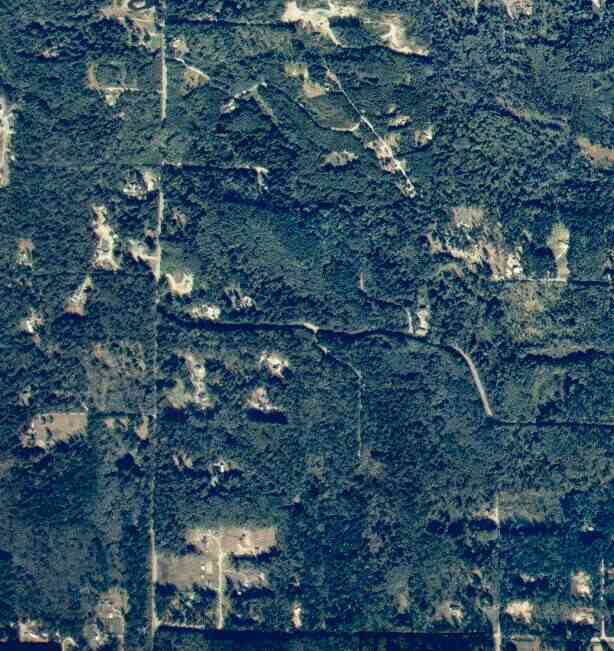
The above September 1997 aerial photo of this section of Camano is from http://www.islandcounty.net/publicworks/digitalphotos/mainmap.htm
The above September 1997 aerial photo of this section of Camano is from
http://www.islandcounty.net/publicworks/digitalphotos/mainmap.htm
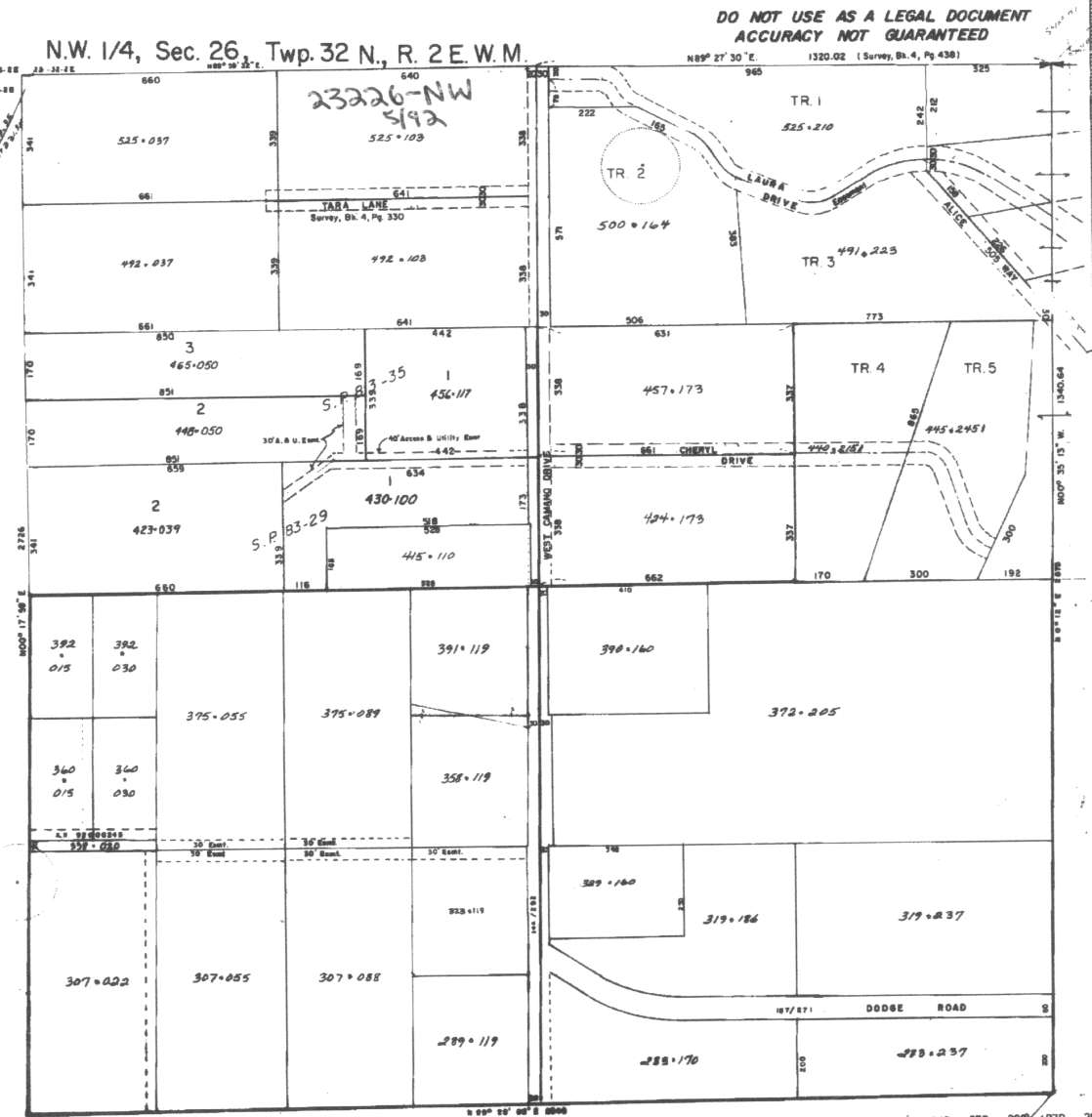
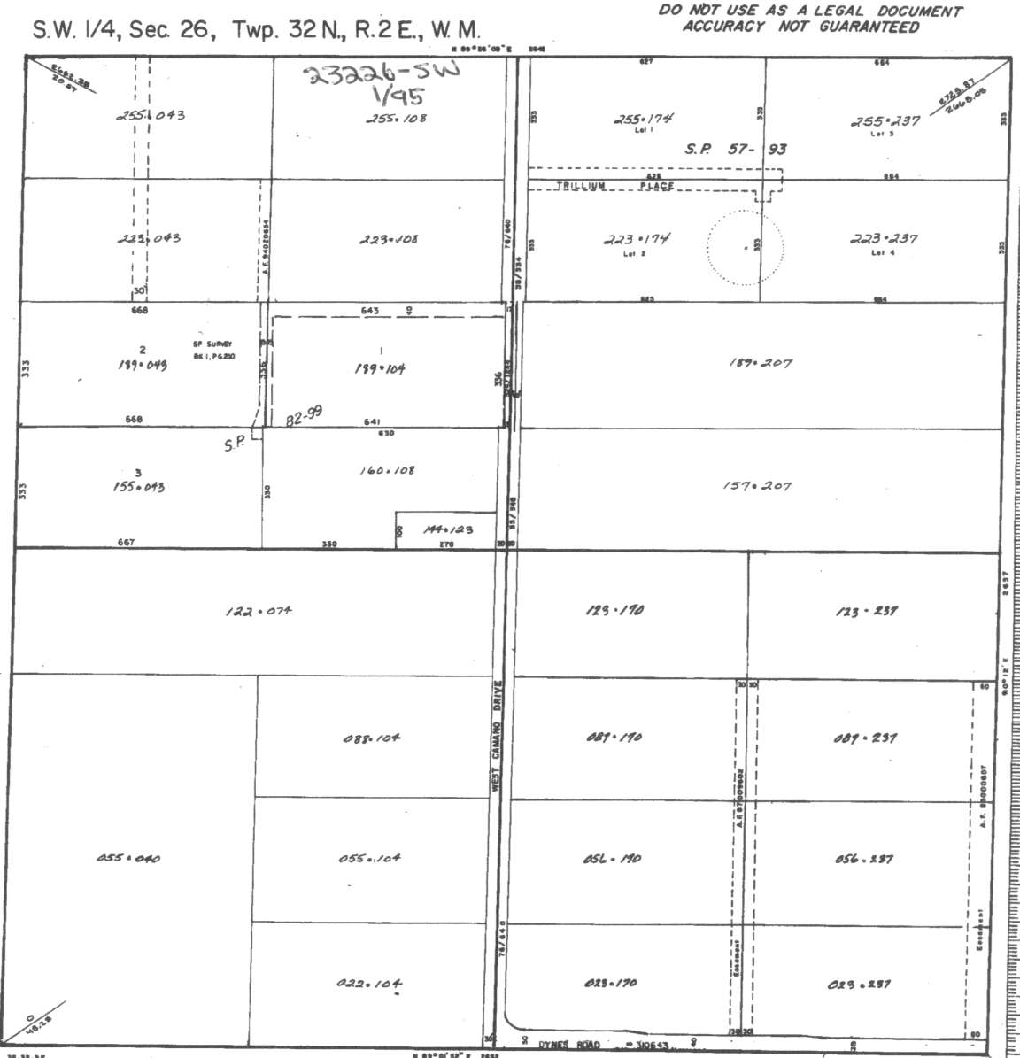
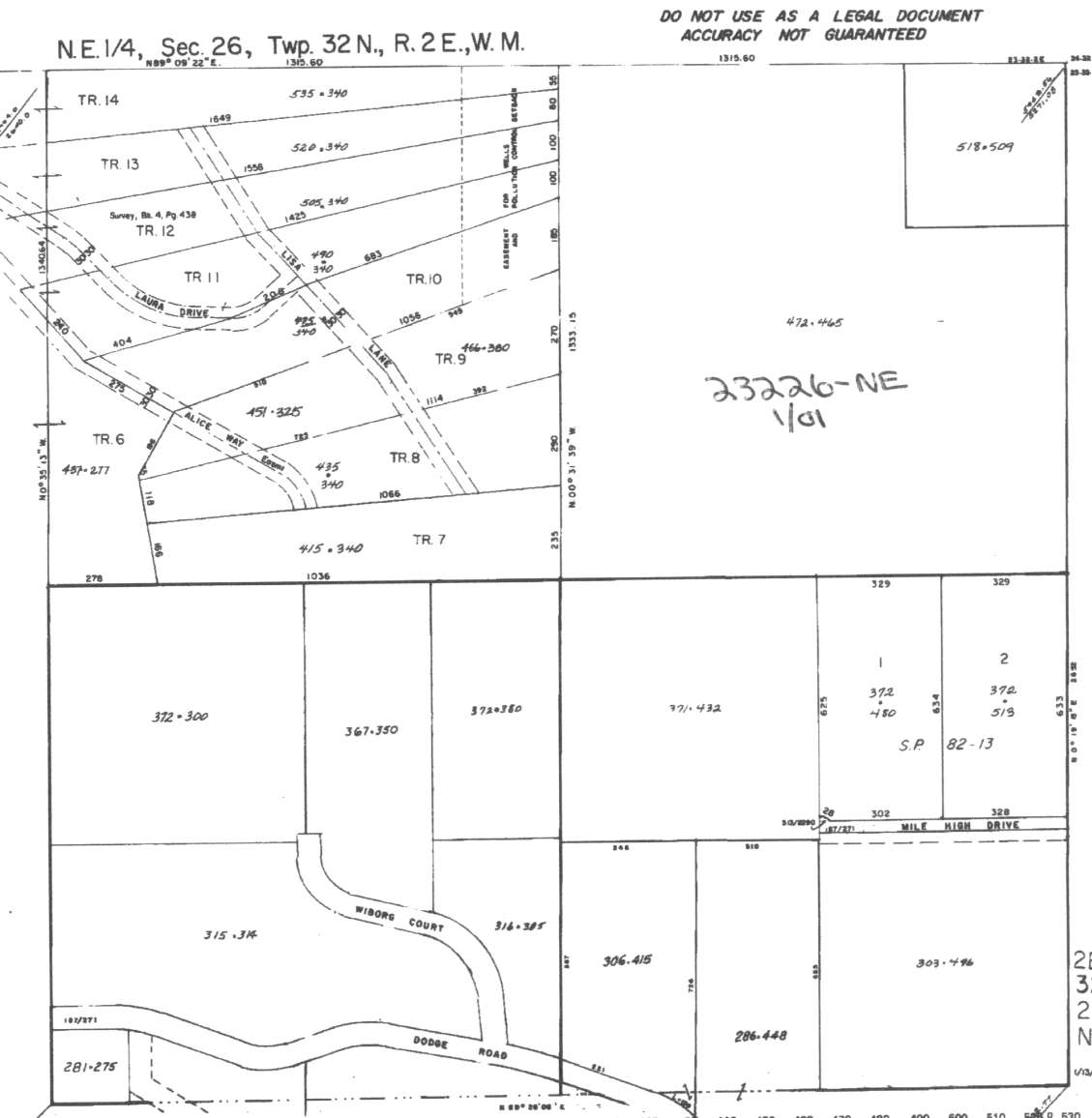
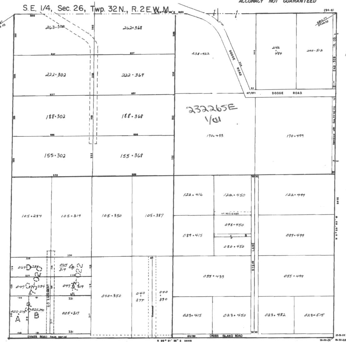
A square system of surveying was ordained by the Continental Congress on May 20, 1785. Within each township (6 miles X 6 miles), are 36 sections. Each section of 640 acres is one mile square (5,280 feet X 5,280 feet). Each quarter section is 160 acres (2,640 feet X 2,640 feet). Most long straight roads and acreage pieces of property have north-south, east-west property lines.
Click on the below Camano section map numbers, to go to a page with Camano Island 2005 assessor data, 1/4 section parcel maps, and aerial photos.
Below are the 24 well reports for this section of Camano, from the December 2004 Washington State Department of Ecology Well log website. Included below is who the well was drilled for, the well depth, and when the well was drilled. At the well log website,
http://apps.ecy.wa.gov/welllog/ more detailed information is available, like the well drillers name, water temperature(sometimes), and soil profile depths.
The below well logs information is from the Washington State Department of Ecology Well log website.
http://apps.ecy.wa.gov/welllog/
 <888>
<888>

1. SUN MOUNTAIN CONSTRUCTIONĀ - { view PDF
Ā|Ā view TIFF
}
Public Land Survey: SE, SE, S-26, T-32-N, R-02-E, Tax Parcel Number: (blank)
County: ISLAND, Well Address: XXX STIEN LANE
Well Log ID: 379469, Well Tag ID: AGF464, Notice of Intent Number: W156126
Well Diameter: 6 (inches), Well Depth: 380 (feet)
Well Type: Water, Well Completion Date: 3/27/2004, Well Log Received Date: 5/12/2004
2. MARY HARDIEĀ - { view PDF
Ā|Ā view TIFF
}
Public Land Survey: SE, SE, S-26, T-32-N, R-02-E, Tax Parcel Number: R23226-055-4330
County: ISLAND, Well Address: 443 N STEIN LN, CAMANO ISLAND 98282
Well Log ID: 372880, Well Tag ID: ABO959, Notice of Intent Number: W153746
Well Diameter: 6 (inches), Well Depth: 148 (feet)
Well Type: Water, Well Completion Date: 10/18/2003, Well Log Received Date: 12/31/2003
3. GABE GILESĀ - { view PDF
Ā|Ā view TIFF
}
Public Land Survey: SE, NE, S-26, T-32-N, R-02-E, Tax Parcel Number: R23226-303-4960
County: ISLAND, Well Address: 423 MILE HIGH RD, CAMANO ISLAND
Well Log ID: 370460, Well Tag ID: AFK013, Notice of Intent Number: W154339
Well Diameter: 6 (inches), Well Depth: 297 (feet)
Well Type: Water, Well Completion Date: 10/3/2003, Well Log Received Date: 10/29/2003
4. JON NIELSENĀ - { view PDF
Ā|Ā view TIFF
}
Public Land Survey: SE, NE, S-26, T-32-N, R-02-E, Tax Parcel Number: (blank)
County: ISLAND, Well Address: XXX CHERYL DR, CAMANO ISLAND
Well Log ID: 355019, Well Tag ID: AGE399, Notice of Intent Number: W151548
Well Diameter: 6 (inches), Well Depth: 213 (feet)
Well Type: Water, Well Completion Date: 3/5/2003, Well Log Received Date: 3/14/2003
5. PATSY AND C. L. NELSONĀ - { view PDF
Ā|Ā view TIFF
}
Public Land Survey: SW, NW, S-26, T-32-N, R-02-E, Tax Parcel Number: R23226-289-1190
County: ISLAND, Well Address: 621 NW CAMANO DR, CAMANO ISLAND, 98282
Well Log ID: 355570, Well Tag ID: ABO930, Notice of Intent Number: W153707
Well Diameter: 6 (inches), Well Depth: 210 (feet)
Well Type: Water, Well Completion Date: 1/31/2003, Well Log Received Date: 3/25/2003
6. LIONEL CONTRARASĀ - { view PDF
Ā|Ā view TIFF
}
Public Land Survey: NE, SE, S-26, T-32-N, R-02-E, Tax Parcel Number: R23226-286-4480
County: ISLAND, Well Address: DODGE RD, CAMANO ISLAND
Well Log ID: 315333, Well Tag ID: AFK013, Notice of Intent Number: W120072
Well Diameter: 6 (inches), Well Depth: 125 (feet)
Well Type: Water, Well Completion Date: 9/11/2001, Well Log Received Date: 9/17/2001
7. BRICE & MICHELLE JONESĀ - { view PDF
Ā|Ā view TIFF
}
Public Land Survey: NW, SE, S-26, T-32-N, R-02-E, Tax Parcel Number: (blank)
County: ISLAND, Well Address: DYNES RD, CAMANO ISLAND
Well Log ID: 72637, Well Tag ID: ABC727, Notice of Intent Number: W094506
Well Diameter: 6 (inches), Well Depth: 400 (feet)
Well Type: Water, Well Completion Date: 5/19/1998, Well Log Received Date: 6/1/1998
8. BRUCE AALMOĀ - { view PDF
Ā|Ā view TIFF
}
Public Land Survey: NE, NW, S-26, T-32-N, R-02-E, Tax Parcel Number: (blank)
County: ISLAND, Well Address: 643 NW CAMANO DR, CAMANO ISLAND
Well Log ID: 62006, Well Tag ID: (blank) , Notice of Intent Number: W073057
Well Diameter: 6 (inches), Well Depth: 345 (feet)
Well Type: Water, Well Completion Date: 8/11/1997, Well Log Received Date: (blank)
9. OMER IRBYĀ - { view PDF
Ā|Ā view TIFF
}
Public Land Survey: SE, SW, S-26, T-32-N, R-02-E, Tax Parcel Number: (blank)
County: ISLAND, Well Address: 461 650 W CAMANO ISLAND
Well Log ID: 68915, Well Tag ID: (blank) , Notice of Intent Number: W090830
Well Diameter: 6 (inches), Well Depth: 316 (feet)
Well Type: Water, Well Completion Date: 4/11/1997, Well Log Received Date: 4/30/1997
10. CHARLES ROTHROCKĀ - { view PDF
Ā|Ā view TIFF
}
Public Land Survey: SW, NW, S-26, T-32-N, R-02-E, Tax Parcel Number: (blank)
County: ISLAND, Well Address: 660 W DODGE RD, CAMANO ISLAND, 98292
Well Log ID: 62362, Well Tag ID: (blank) , Notice of Intent Number: W054364
Well Diameter: 6 (inches), Well Depth: 343 (feet)
Well Type: Water, Well Completion Date: 11/6/1996, Well Log Received Date: 12/4/1996
11. KEN HOLMBERGĀ - { view PDF
Ā|Ā view TIFF
}
Public Land Survey: NW, NW, S-26, T-32-N, R-02-E, Tax Parcel Number: (blank)
County: ISLAND, Well Address: 700 W CAMANO DR, CAMANO ISLAND, 98292
Well Log ID: 66735, Well Tag ID: (blank) , Notice of Intent Number: W073035
Well Diameter: 6 (inches), Well Depth: 180 (feet)
Well Type: Water, Well Completion Date: 6/18/1996, Well Log Received Date: 7/16/1996
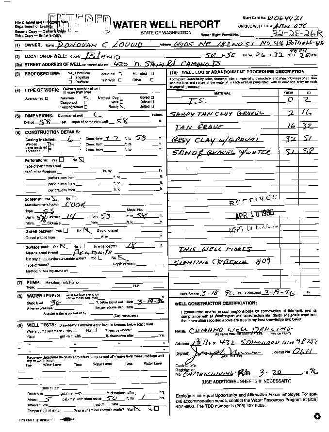
12. DONOVAN LOVOIDĀ - { view PDF
Ā|Ā view TIFF
}
Public Land Survey: SE, SE, S-26, T-32-N, R-02-E, Tax Parcel Number: (blank)
County: ISLAND, Well Address: 420 N STEIN RD, CAMANO ISLAND
Well Log ID: 63662, Well Tag ID: (blank) , Notice of Intent Number: W064421
Well Diameter: 6 (inches), Well Depth: 58 (feet)
Well Type: Water, Well Completion Date: 3/19/1996, Well Log Received Date: 4/10/1996
13. MIKE LYNNĀ - { view PDF
Ā|Ā view TIFF
}
Public Land Survey: NW, SW, S-26, T-32-N, R-02-E, Tax Parcel Number: (blank)
County: ISLAND, Well Address: 521 N WEST CAMANO DR, CAMANO ISLAND
Well Log ID: 68037, Well Tag ID: (blank) , Notice of Intent Number: W043568
Well Diameter: 6 (inches), Well Depth: 247 (feet)
Well Type: Water, Well Completion Date: 9/26/1994, Well Log Received Date: 10/11/1994
14. DANA PRATTĀ - { view PDF
Ā|Ā view TIFF
}
Public Land Survey: SE, SW, S-26, T-32-N, R-02-E, Tax Parcel Number: (blank)
County: ISLAND, Well Address: 650 W CAMANO ISLAND RD, CAMANO ISLAND
Well Log ID: 62910, Well Tag ID: (blank) , Notice of Intent Number: W018164
Well Diameter: 6 (inches), Well Depth: 342 (feet)
Well Type: Water, Well Completion Date: 8/3/1994, Well Log Received Date: 8/10/1994
15. RON COSTERĀ - { view PDF
Ā|Ā view TIFF
}
Public Land Survey: NE, SE, S-26, T-32-N, R-02-E, Tax Parcel Number: (blank)
County: ISLAND, Well Address: (blank)
Well Log ID: 70208, Well Tag ID: (blank) , Notice of Intent Number: W010614
Well Diameter: 6 (inches), Well Depth: 285 (feet)
Well Type: Water, Well Completion Date: 3/4/1994, Well Log Received Date: 3/17/1994
16. JAN BUDDENĀ - { view PDF
Ā|Ā view TIFF
}
Public Land Survey: NW, NW, S-26, T-32-N, R-02-E, Tax Parcel Number: (blank)
County: ISLAND, Well Address: (blank)
Well Log ID: 65648, Well Tag ID: (blank) , Notice of Intent Number: W010613
Well Diameter: 6 (inches), Well Depth: 274 (feet)
Well Type: Water, Well Completion Date: 2/11/1994, Well Log Received Date: 2/18/1994
17. GREG & WENDY SIMUNDĀ - { view PDF
Ā|Ā view TIFF
}
Public Land Survey: SW, SW, S-26, T-32-N, R-02-E, Tax Parcel Number: (blank)
County: ISLAND, Well Address: DYNES RD
Well Log ID: 64889, Well Tag ID: (blank) , Notice of Intent Number: W010610
Well Diameter: 6 (inches), Well Depth: 120 (feet)
Well Type: Water, Well Completion Date: 8/15/1993, Well Log Received Date: 9/23/1993
18. SYLVESTER & ELLEN ROBERTSĀ - { view PDF
Ā|Ā view TIFF
}
Public Land Survey: SW, SW, S-26, T-32-N, R-02-E, Tax Parcel Number: (blank)
County: ISLAND, Well Address: 411 N STEIN, CAMANO ISLAND, 98292
Well Log ID: 70918, Well Tag ID: (blank) , Notice of Intent Number: (blank)
Well Diameter: 6 (inches), Well Depth: 66 (feet)
Well Type: Water, Well Completion Date: 5/10/1993, Well Log Received Date: 5/27/1993
19. DON STEINĀ - { view PDF
Ā|Ā view TIFF
}
Public Land Survey: SW, NE, S-26, T-32-N, R-02-E, Tax Parcel Number: (blank)
County: ISLAND, Well Address: 620 WIBORG CT, CAMANO ISLAND
Well Log ID: 63581, Well Tag ID: (blank) , Notice of Intent Number: (blank)
Well Diameter: 6 (inches), Well Depth: 217 (feet)
Well Type: Water, Well Completion Date: 9/28/1992, Well Log Received Date: 10/16/1992
20. ROBERT & DIANE BROOKSĀ - { view PDF
Ā|Ā view TIFF
}
Public Land Survey: SE, SE, S-26, T-32-N, R-02-E, Tax Parcel Number: (blank)
County: ISLAND, Well Address: (blank)
Well Log ID: 118036, Well Tag ID: (blank) , Notice of Intent Number: 073635
Well Diameter: 6 (inches), Well Depth: 266 (feet)
Well Type: Water, Well Completion Date: 7/30/1992, Well Log Received Date: (blank)
21. STEVE FLINNĀ - { view PDF
Ā|Ā view TIFF
}
Public Land Survey: SW, SE, S-26, T-32-N, R-02-E, Tax Parcel Number: (blank)
County: ISLAND, Well Address: 650 W DYNES
Well Log ID: 70756, Well Tag ID: (blank) , Notice of Intent Number: (blank)
Well Diameter: 6 (inches), Well Depth: 290 (feet)
Well Type: Water, Well Completion Date: 6/1/1992, Well Log Received Date: (blank)
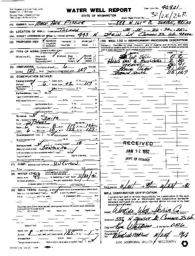
22. MARY FISHERĀ - { view PDF
Ā|Ā view TIFF
}
Public Land Survey: SE, SE, S-26, T-32-N, R-02-E, Tax Parcel Number: (blank)
County: ISLAND, Well Address: 443 N STEIN LN, CAMANO ISLAND, 98292
Well Log ID: 67754, Well Tag ID: (blank) , Notice of Intent Number: 040901
Well Diameter: 6 (inches), Well Depth: 127 (feet)
Well Type: Water, Well Completion Date: 11/23/1991, Well Log Received Date: 1/22/1992
23. DON REYNOLDSĀ - { view PDF
Ā|Ā view TIFF
}
Public Land Survey: SE, SE, S-26, T-32-N, R-02-E, Tax Parcel Number: (blank)
County: ISLAND, Well Address: 440 N 450 W, CAMANO ISLAND
Well Log ID: 63568, Well Tag ID: (blank) , Notice of Intent Number: (blank)
Well Diameter: 6 (inches), Well Depth: 60 (feet)
Well Type: Water, Well Completion Date: 6/24/1987, Well Log Received Date: (blank)
24. DAN DODGEĀ - { view PDF
Ā|Ā view TIFF
}
Public Land Survey: SE, NW, S-26, T-32-N, R-02-E, Tax Parcel Number: (blank)
County: ISLAND, Well Address: (blank)
Well Log ID: 62842, Well Tag ID: (blank) , Notice of Intent Number: (blank)
Well Diameter: 6 (inches), Well Depth: 320 (feet)
Well Type: Water, Well Completion Date: (blank) , Well Log Received Date: (blank)
wr23226steinlnlovoid1996nunes
wr23226steinlnfisher1992watkins