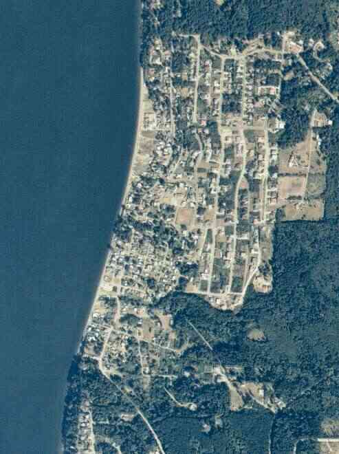
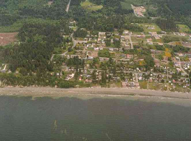
The above September 1997 aerial photo of this section of Camano is from http://www.islandcounty.net/publicworks/digitalphotos/mainmap.htm
The above September 1997 aerial photo of this section of Camano is from
http://www.islandcounty.net/publicworks/digitalphotos/mainmap.htm
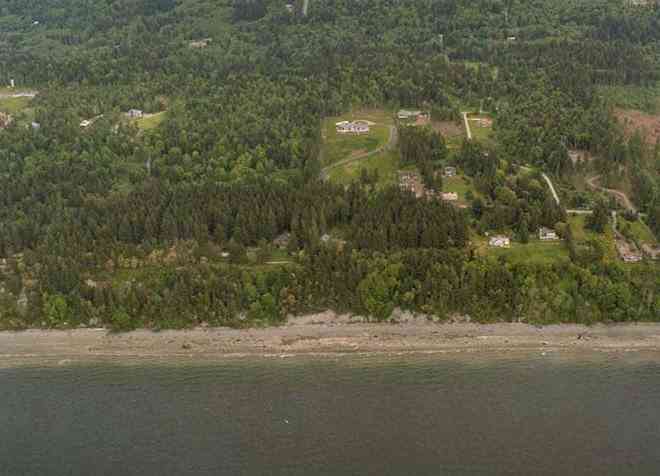
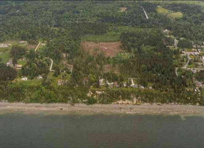
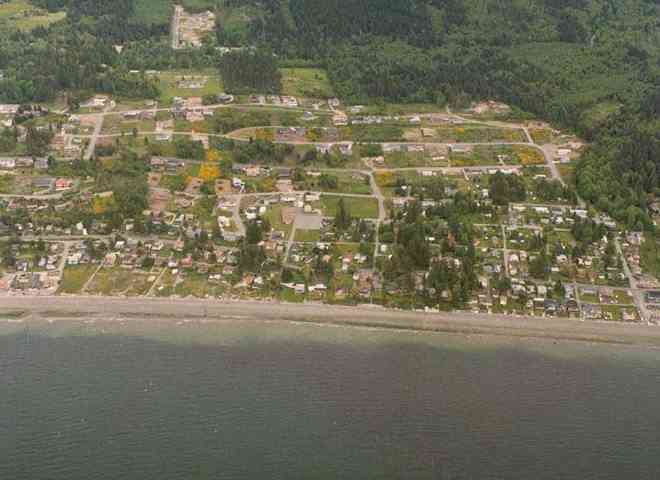
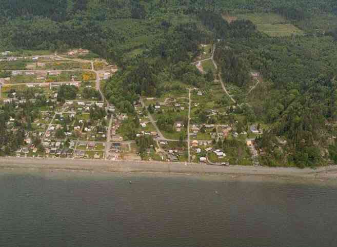
The below 5/8/1993 2:30:00 PM aerial photos are from:
http://apps.ecy.wa.gov/shorephotos
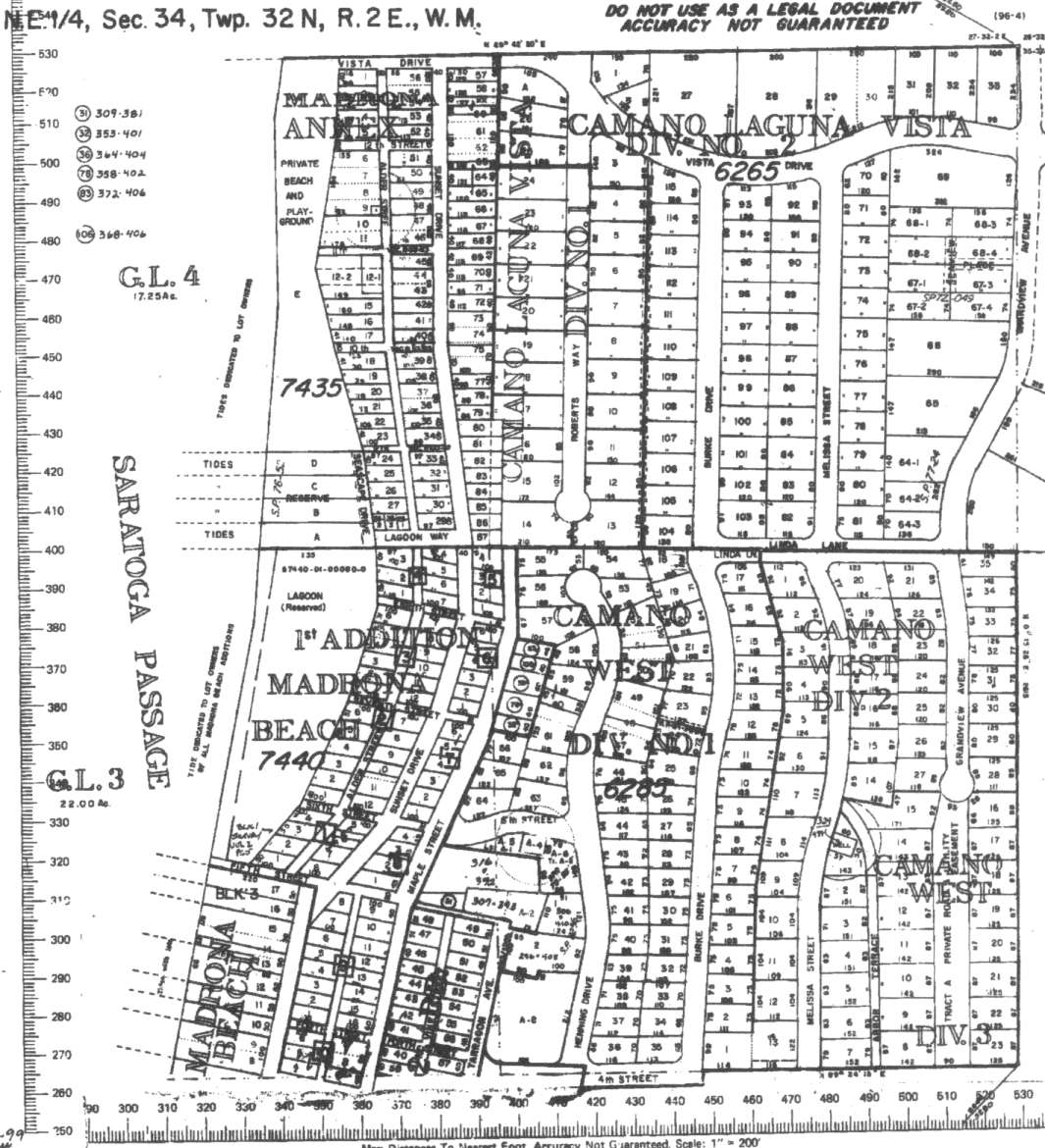
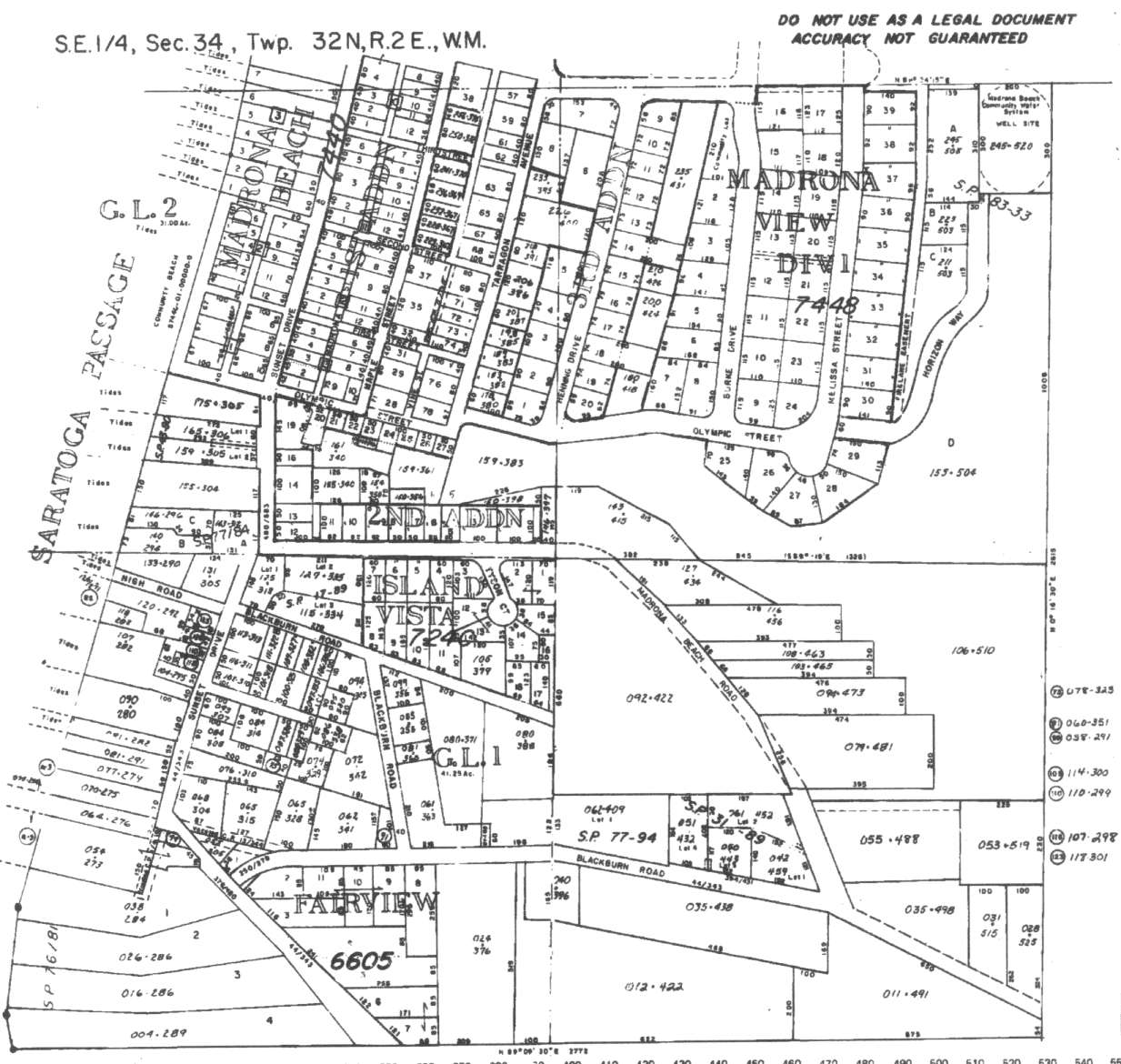
A square system of surveying was ordained by the Continental Congress on May 20, 1785. Within each township (6 miles X 6 miles), are 36 sections. Each section of 640 acres is one mile square (5,280 feet X 5,280 feet). Each quarter section is 160 acres (2,640 feet X 2,640 feet). Most long straight roads and acreage pieces of property have north-south, east-west property lines.
Click on the below Camano section map numbers, to go to a page with Camano Island 2005 assessor data, 1/4 section parcel maps, and aerial photos.
Below are the 19 well reports for this section of Camano, from the December 2004 Washington State Department of Ecology Well log website. Included below is who the well was drilled for, the well depth, and when the well was drilled. At the well log website,
http://apps.ecy.wa.gov/welllog/ more detailed information is available, like the well drillers name, water temperature(sometimes), and soil profile depths.
The below well logs information is from the Washington State Department of Ecology Well log website.
http://apps.ecy.wa.gov/welllog/
 <888>
<888>

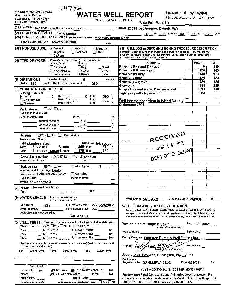
1. WILLIAM AND JANICE ERICKSONĀ - { view PDF
Ā|Ā view TIFF
}
Public Land Survey: SE, SE, S-34, T-32-N, R-02-E, Tax Parcel Number: R23235 049 160
County: ISLAND, Well Address: MADRONA BEACH RD
Well Log ID: 334733, Well Tag ID: AGL159, Notice of Intent Number: W147460
Well Diameter: 6 (inches), Well Depth: 380 (feet)
Well Type: Water, Well Completion Date: 5/29/2002, Well Log Received Date: 6/18/2002
2. WENDALL JOHNSONĀ - { view PDF
Ā|Ā view TIFF
}
Public Land Survey: SE, SE, S-34, T-32-N, R-02-E, Tax Parcel Number: (blank)
County: ISLAND, Well Address: MADRONA BEACH AREA CAMANO ISLAND
Well Log ID: 246424, Well Tag ID: AES608, Notice of Intent Number: W110065
Well Diameter: 6 (inches), Well Depth: 295 (feet)
Well Type: Water, Well Completion Date: 10/21/1999, Well Log Received Date: 10/29/1999
3. RUTH YORKĀ - { view PDF
Ā|Ā view TIFF
}
Public Land Survey: SE, SW, S-34, T-32-N, R-02-E, Tax Parcel Number: (blank)
County: ISLAND, Well Address: 73 E SUNSET DR, CAMANO ISLAND
Well Log ID: 70436, Well Tag ID: (blank) , Notice of Intent Number: A009159
Well Diameter: 36 (inches), Well Depth: 86 (feet)
Well Type: Decommissioned, Well Completion Date: 11/5/1998, Well Log Received Date: 11/20/1998
4. DIMMICKĀ - { view PDF
Ā|Ā view TIFF
}
Public Land Survey: NE, SW, S-34, T-32-N, R-02-E, Tax Parcel Number: (blank)
County: ISLAND, Well Address: 206 N SUNSET DR, CAMANO ISLAND
Well Log ID: 63458, Well Tag ID: (blank) , Notice of Intent Number: A003030
Well Diameter: 6 (inches), Well Depth: (blank)
Well Type: Decommissioned, Well Completion Date: 8/12/1998, Well Log Received Date: 9/3/1998
5. KURT & RENEE WINTERHALTERĀ - { view PDF
Ā|Ā view TIFF
}
Public Land Survey: NE, NW, S-34, T-32-N, R-02-E, Tax Parcel Number: (blank)
County: ISLAND, Well Address: 190 HENNING DR, CAMANO ISLAND, 98292
Well Log ID: 66935, Well Tag ID: (blank) , Notice of Intent Number: A003034
Well Diameter: 6 (inches), Well Depth: 90 (feet)
Well Type: Decommissioned, Well Completion Date: 4/11/1997, Well Log Received Date: 4/20/1997
6. JOHN TETERĀ - { view PDF
Ā|Ā view TIFF
}
Public Land Survey: SW, SW, S-34, T-32-N, R-02-E, Tax Parcel Number: (blank)
County: ISLAND, Well Address: 903 MADRONA BEACH RD, CAMANO ISLAND, 98292
Well Log ID: 66487, Well Tag ID: (blank) , Notice of Intent Number: A003022
Well Diameter: 6 (inches), Well Depth: 97 (feet)
Well Type: Decommissioned, Well Completion Date: 7/15/1996, Well Log Received Date: 8/12/1996
7. TED MARSHALLĀ - { view PDF
Ā|Ā view TIFF
}
Public Land Survey: SE, SE, S-34, T-32-N, R-02-E, Tax Parcel Number: (blank)
County: ISLAND, Well Address: MADRONA BEEL RD, CAMANO ISLAND
Well Log ID: 70969, Well Tag ID: (blank) , Notice of Intent Number: W043590
Well Diameter: 6 (inches), Well Depth: 335 (feet)
Well Type: Water, Well Completion Date: 4/27/1995, Well Log Received Date: 6/19/1995
8. KIP GOOZEEĀ - { view PDF
Ā|Ā view TIFF
}
Public Land Survey: SE, SE, S-34, T-32-N, R-02-E, Tax Parcel Number: (blank)
County: ISLAND, Well Address: 59 N BLACKBURN RD, CAMANO ISLAND, 98292
Well Log ID: 66879, Well Tag ID: (blank) , Notice of Intent Number: 210319
Well Diameter: 6 (inches), Well Depth: 290 (feet)
Well Type: Water, Well Completion Date: 2/12/1993, Well Log Received Date: 4/9/1993
9. PETE NELSONĀ - { view PDF
Ā|Ā view TIFF
}
Public Land Survey: SE, SW, S-34, T-32-N, R-02-E, Tax Parcel Number: (blank)
County: ISLAND, Well Address: N SUNSET DR, CAMANO ISLAND, 98292
Well Log ID: 69215, Well Tag ID: (blank) , Notice of Intent Number: 040927
Well Diameter: 6 (inches), Well Depth: 192 (feet)
Well Type: Water, Well Completion Date: 4/10/1992, Well Log Received Date: 5/7/1992
10. MEL TORSETHĀ - { view PDF
Ā|Ā view TIFF
}
Public Land Survey: SW, SW, S-34, T-32-N, R-02-E, Tax Parcel Number: (blank)
County: ISLAND, Well Address: 2 S WEST BEACH DR, CAMANO ISLAND, 98292
Well Log ID: 67841, Well Tag ID: (blank) , Notice of Intent Number: 070347
Well Diameter: 6 (inches), Well Depth: 220 (feet)
Well Type: Water, Well Completion Date: 6/22/1990, Well Log Received Date: (blank)
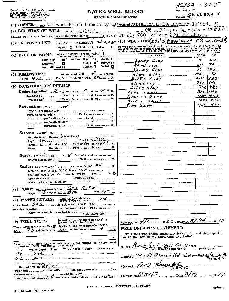
11. MADRONA BEACH COMM. WATER SYSTEMĀ - { view PDF
Ā|Ā view TIFF
}
Public Land Survey: NE, SE, S-34, T-32-N, R-02-E, Tax Parcel Number: (blank)
County: ISLAND, Well Address: GREENVIEW RD
Well Log ID: 67529, Well Tag ID: AGA739, Notice of Intent Number: (blank)
Well Diameter: 8 (inches), Well Depth: 471 (feet)
Well Type: Water, Well Completion Date: 5/24/1977, Well Log Received Date: (blank)
12. HOWARD FAIRBAIRNĀ - { view PDF
Ā|Ā view TIFF
}
Public Land Survey: (blank), (blank), S-34, T-32-N, R-02-E, Tax Parcel Number: (blank)
County: ISLAND, Well Address: (blank)
Well Log ID: 65278, Well Tag ID: (blank) , Notice of Intent Number: (blank)
Well Diameter: 6 (inches), Well Depth: 101 (feet)
Well Type: Water, Well Completion Date: 7/26/1972, Well Log Received Date: (blank)
13. A. L. THEISENĀ - { view PDF
Ā|Ā view TIFF
}
Public Land Survey: NE, NE, S-34, T-32-N, R-02-E, Tax Parcel Number: (blank)
County: ISLAND, Well Address: (blank)
Well Log ID: 60970, Well Tag ID: (blank) , Notice of Intent Number: (blank)
Well Diameter: 6 (inches), Well Depth: 97 (feet)
Well Type: Water, Well Completion Date: 3/14/1961, Well Log Received Date: (blank)
14. CLYDE & EDITH ROBINSONĀ - { view PDF
Ā|Ā view TIFF
}
Public Land Survey: (blank), (blank), S-34, T-32-N, R-02-E, Tax Parcel Number: (blank)
County: ISLAND, Well Address: ALDER ST
Well Log ID: 62597, Well Tag ID: AGA507, Notice of Intent Number: (blank)
Well Diameter: 6 (inches), Well Depth: 152 (feet)
Well Type: Water, Well Completion Date: (blank) , Well Log Received Date: (blank)
15. SUNSET WATER DISTRIBUTORS INCĀ - { view PDF
Ā|Ā view TIFF
}
Public Land Survey: SE, NE, S-34, T-32-N, R-02-E, Tax Parcel Number: (blank)
County: ISLAND, Well Address: (blank)
Well Log ID: 70892, Well Tag ID: AGA740, Notice of Intent Number: (blank)
Well Diameter: 6 (inches), Well Depth: 192 (feet)
Well Type: Water, Well Completion Date: (blank) , Well Log Received Date: 11/18/1982
16. CLINTON D PARKERĀ - { view PDF
Ā|Ā view TIFF
}
Public Land Survey: SW, NE, S-34, T-32-N, R-02-E, Tax Parcel Number: (blank)
County: ISLAND, Well Address: (blank)
Well Log ID: 351177, Well Tag ID: (blank) , Notice of Intent Number: (blank)
Well Diameter: 24 (inches), Well Depth: 42 (feet)
Well Type: Water, Well Completion Date: (blank) , Well Log Received Date: (blank)
17. C PAUL GROSENICKĀ - { view PDF
Ā|Ā view TIFF
}
Public Land Survey: NW, NE, S-34, T-32-N, R-02-E, Tax Parcel Number: (blank)
County: ISLAND, Well Address: (blank)
Well Log ID: 351178, Well Tag ID: (blank) , Notice of Intent Number: (blank)
Well Diameter: 6 (inches), Well Depth: 166 (feet)
Well Type: Water, Well Completion Date: (blank) , Well Log Received Date: (blank)
18. CLINTON D PARKERĀ - { view PDF
Ā|Ā view TIFF
}
Public Land Survey: SE, NE, S-34, T-32-N, R-02-E, Tax Parcel Number: (blank)
County: ISLAND, Well Address: (blank)
Well Log ID: 351179, Well Tag ID: (blank) , Notice of Intent Number: (blank)
Well Diameter: 24 (inches), Well Depth: 66 (feet)
Well Type: Water, Well Completion Date: (blank) , Well Log Received Date: (blank)
19. CAMANO WEST WATER ASSNĀ - { view PDF
Ā|Ā view TIFF
}
Public Land Survey: SE, NE, S-34, T-32-N, R-02-E, Tax Parcel Number: (blank)
County: ISLAND, Well Address: (blank)
Well Log ID: 351181, Well Tag ID: (blank) , Notice of Intent Number: (blank)
Well Diameter: 6 (inches), Well Depth: 372 (feet)
Well Type: Water, Well Completion Date: (blank) , Well Log Received Date: (blank)
wr23234madronaerickson2002dahlman
wr23234madronabeach1977kounkel