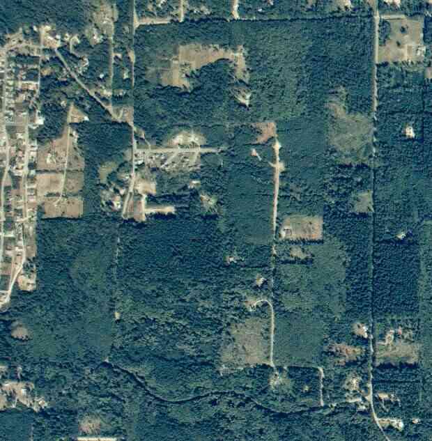
The above September 1997 aerial photo of this section of Camano is from http://www.islandcounty.net/publicworks/digitalphotos/mainmap.htm
The above September 1997 aerial photo of this section of Camano is from
http://www.islandcounty.net/publicworks/digitalphotos/mainmap.htm
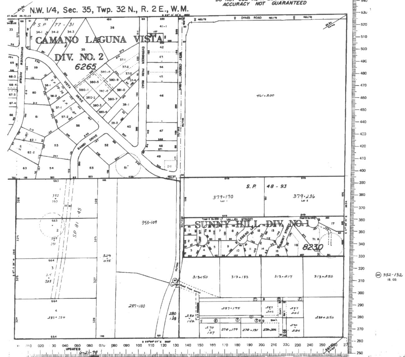
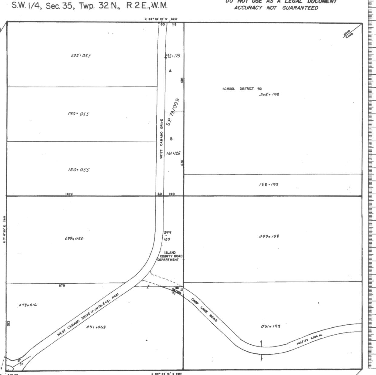
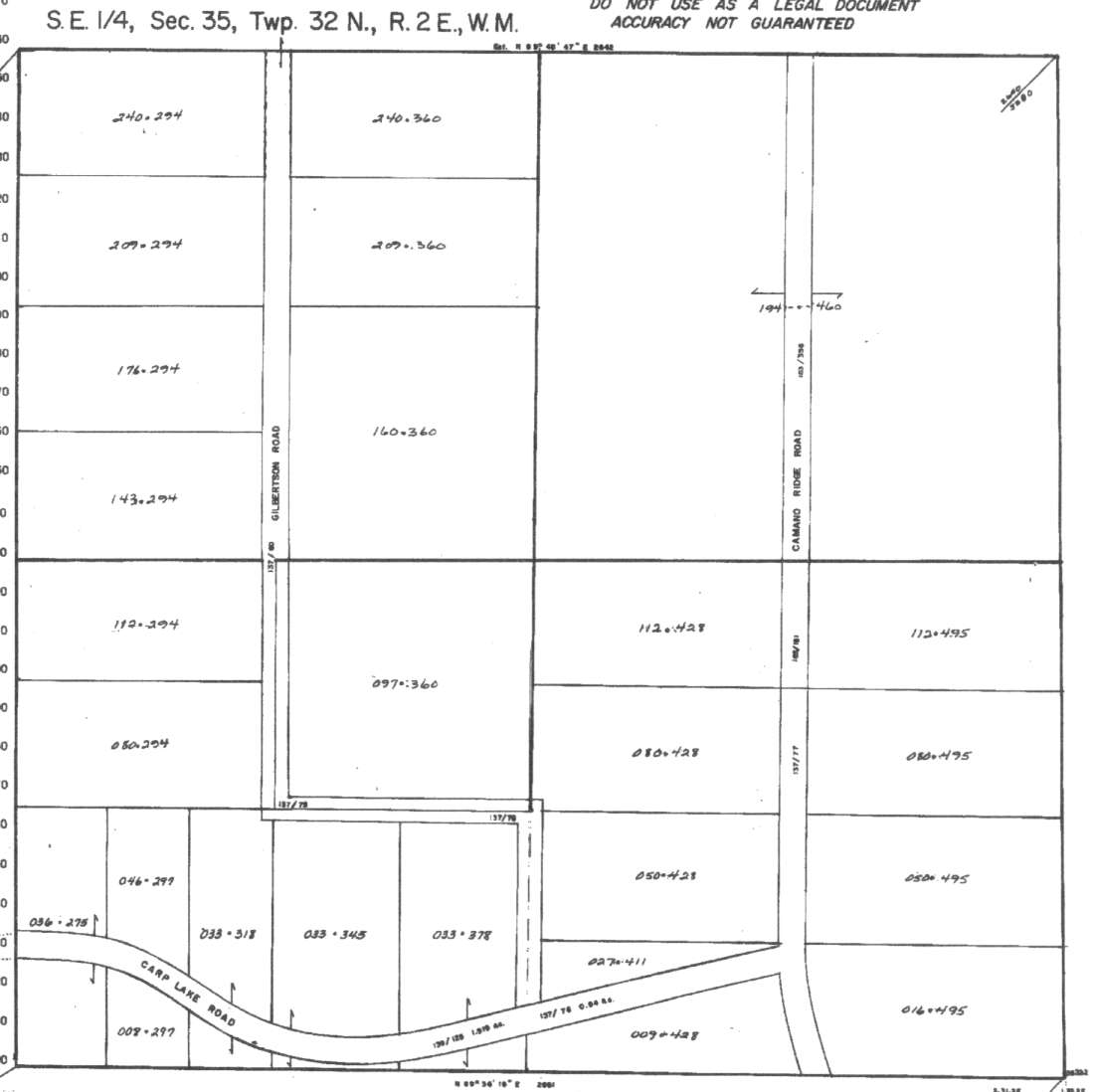
A square system of surveying was ordained by the Continental Congress on May 20, 1785. Within each township (6 miles X 6 miles), are 36 sections. Each section of 640 acres is one mile square (5,280 feet X 5,280 feet). Each quarter section is 160 acres (2,640 feet X 2,640 feet). Most long straight roads and acreage pieces of property have north-south, east-west property lines.
Click on the below Camano section map numbers, to go to a page with Camano Island 2005 assessor data, 1/4 section parcel maps, and aerial photos.
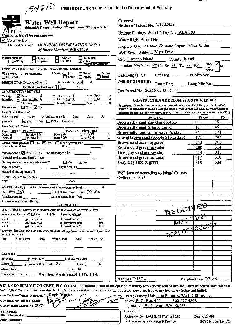
Below are the 26 well reports for this section of Camano, from the December 2004 Washington State Department of Ecology Well log website. Included below is who the well was drilled for, the well depth, and when the well was drilled. At the well log website,
http://apps.ecy.wa.gov/welllog/ more detailed information is available, like the well drillers name, water temperature(sometimes), and soil profile depths.
The below well logs information is from the Washington State Department of Ecology Well log website.
http://apps.ecy.wa.gov/welllog/

 <888>
<888>

1. DOUG AND KATHY BLANKĀ - { view PDF
Ā|Ā view TIFF
}
Public Land Survey: NE, NE, S-35, T-32-N, R-02-E, Tax Parcel Number: (blank)
County: ISLAND, Well Address: 314 N CAMANO RIDGE RD, CAMANO ISLAND
Well Log ID: 384890, Well Tag ID: AKY979, Notice of Intent Number: W177638
Well Diameter: 6 (inches), Well Depth: 136.5 (feet)
Well Type: Water, Well Completion Date: 7/23/2004, Well Log Received Date: 8/18/2004
2. CAMANO LAGUNA VISTA WATER ASSOCĀ - { view PDF
Ā|Ā view TIFF
}
Public Land Survey: NW, SW, S-35, T-32-N, R-02-E, Tax Parcel Number: S6265-02-00051-0
County: ISLAND, Well Address: VISTA DR, CAMANO ISLAND 98282
Well Log ID: 385659, Well Tag ID: ALA293, Notice of Intent Number: WE02439
Well Diameter: 6 (inches), Well Depth: 314 (feet)
Well Type: Water, Well Completion Date: 7/21/2004, Well Log Received Date: 8/17/2004
3. JOE SCHMOE CONSTRUCTIONĀ - { view PDF
Ā|Ā view TIFF
}
Public Land Survey: SE, NE, S-35, T-32-N, R-02-E, Tax Parcel Number: (blank)
County: ISLAND, Well Address: XXX GILBERTSON RD, CAMANO ISLAND 98282
Well Log ID: 386470, Well Tag ID: AGF482, Notice of Intent Number: W156144
Well Diameter: 6 (inches), Well Depth: 105 (feet)
Well Type: Water, Well Completion Date: 7/20/2004, Well Log Received Date: 9/16/2004
4. CHARLES TILLMANĀ - { view PDF
Ā|Ā view TIFF
}
Public Land Survey: SW, SE, S-35, T-32-N, R-02-E, Tax Parcel Number: R23235-112-294
County: ISLAND, Well Address: OFF GILBERTSON RD, CAMANO ISLAND 98282
Well Log ID: 373421, Well Tag ID: AHG092, Notice of Intent Number: WE01701
Well Diameter: 6 (inches), Well Depth: 441 (feet)
Well Type: Water, Well Completion Date: 12/11/2003, Well Log Received Date: 1/2/2004
5. SUN MOUNTAIN CONSTRUCTIONĀ - { view PDF
Ā|Ā view TIFF
}
Public Land Survey: NE, NE, S-35, T-32-N, R-02-E, Tax Parcel Number: (blank)
County: ISLAND, Well Address: XXX CAMANO RIDGE RD, CAMANO ISLAND
Well Log ID: 367891, Well Tag ID: AGF439, Notice of Intent Number: W156103
Well Diameter: 6 (inches), Well Depth: 125 (feet)
Well Type: Water, Well Completion Date: 8/26/2003, Well Log Received Date: 8/29/2003
6. BOB SCHWICTZERĀ - { view PDF
Ā|Ā view TIFF
}
Public Land Survey: NE, NE, S-35, T-32-N, R-02-E, Tax Parcel Number: (blank)
County: ISLAND, Well Address: 332 CAMANO RIDGE RD, CAMANO ISLAND 98282
Well Log ID: 366569, Well Tag ID: AGF433, Notice of Intent Number: W156093
Well Diameter: 6 (inches), Well Depth: 70 (feet)
Well Type: Water, Well Completion Date: 6/11/2003, Well Log Received Date: 8/5/2003
7. SUN MOUNTAIN CONSTRUCTIONĀ - { view PDF
Ā|Ā view TIFF
}
Public Land Survey: SE, NE, S-35, T-32-N, R-02-E, Tax Parcel Number: (blank)
County: ISLAND, Well Address: CAMANO RIDGE RD, CAMANO ISLAND 98282
Well Log ID: 345901, Well Tag ID: AGF428, Notice of Intent Number: W156072
Well Diameter: 6 (inches), Well Depth: 120 (feet)
Well Type: Water, Well Completion Date: 9/17/2002, Well Log Received Date: 11/8/2002
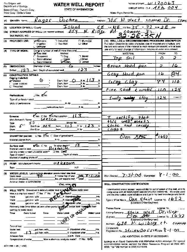
8. ROGER DOCKENĀ - { view PDF
Ā|Ā view TIFF
}
Public Land Survey: SE, NE, S-35, T-32-N, R-02-E, Tax Parcel Number: (blank)
County: ISLAND, Well Address: 254 N RIDGE RD CAMANO IS
Well Log ID: 247758, Well Tag ID: AFK004, Notice of Intent Number: W120063
Well Diameter: 6 (inches), Well Depth: 123 (feet)
Well Type: Water, Well Completion Date: 8/1/2000, Well Log Received Date: 8/3/2000
9. LEONARD HOMES INCĀ - { view PDF
Ā|Ā view TIFF
}
Public Land Survey: SW, NE, S-35, T-32-N, R-02-E, Tax Parcel Number: (blank)
County: ISLAND, Well Address: 274 GILBERTSON ROAD CAMANO ISLAND
Well Log ID: 247757, Well Tag ID: AFJ952, Notice of Intent Number: W116550
Well Diameter: 6 (inches), Well Depth: 356 (feet)
Well Type: Water, Well Completion Date: 7/5/2000, Well Log Received Date: 7/28/2000
10. BILL GREENĀ - { view PDF
Ā|Ā view TIFF
}
Public Land Survey: SW, SE, S-35, T-32-N, R-02-E, Tax Parcel Number: (blank)
County: ISLAND, Well Address: 82 GILBERTSON RD, CAMANO ISLAND
Well Log ID: 190369, Well Tag ID: AEF910, Notice of Intent Number: W099623
Well Diameter: 6 (inches), Well Depth: 421 (feet)
Well Type: Water, Well Completion Date: 8/10/1999, Well Log Received Date: 8/27/1999
11. PETER NAYARĀ - { view PDF
Ā|Ā view TIFF
}
Public Land Survey: SE, NW, S-35, T-32-N, R-02-E, Tax Parcel Number: (blank)
County: ISLAND, Well Address: 623 W 225 N, CAMANO ISLAND, 98292
Well Log ID: 69247, Well Tag ID: (blank) , Notice of Intent Number: A003098
Well Diameter: 6 (inches), Well Depth: 200 (feet)
Well Type: Decommissioned, Well Completion Date: 8/27/1998, Well Log Received Date: 9/3/1998
12. DON SHAURĀ - { view PDF
Ā|Ā view TIFF
}
Public Land Survey: SW, SW, S-35, T-32-N, R-02-E, Tax Parcel Number: (blank)
County: ISLAND, Well Address: 715 CARP LAKE RD, CAMANO ISLAND, 98292
Well Log ID: 73878, Well Tag ID: ACY318, Notice of Intent Number: W099118
Well Diameter: 6 (inches), Well Depth: 145 (feet)
Well Type: Water, Well Completion Date: 7/17/1998, Well Log Received Date: 8/17/1998
13. SCOTT CAMPBELLĀ - { view PDF
Ā|Ā view TIFF
}
Public Land Survey: NW, SE, S-35, T-32-N, R-02-E, Tax Parcel Number: (blank)
County: ISLAND, Well Address: 255 GILBERTSON RD, CAMANO ISLAND
Well Log ID: 72669, Well Tag ID: ABD501, Notice of Intent Number: W099998
Well Diameter: 6 (inches), Well Depth: 340 (feet)
Well Type: Water, Well Completion Date: 4/28/1998, Well Log Received Date: 5/12/1998
14. RANDY & JESSICA JANSMAĀ - { view PDF
Ā|Ā view TIFF
}
Public Land Survey: SW, NE, S-35, T-32-N, R-02-E, Tax Parcel Number: (blank)
County: ISLAND, Well Address: 277 N GILBERTSON RD, CAMANO ISLAND, 98292
Well Log ID: 69488, Well Tag ID: (blank) , Notice of Intent Number: W094502
Well Diameter: (blank) , Well Depth: (blank)
Well Type: Water, Well Completion Date: 3/26/1998, Well Log Received Date: 7/7/1998
15. DARRYL JONESĀ - { view PDF
Ā|Ā view TIFF
}
Public Land Survey: SW, NW, S-35, T-32-N, R-02-E, Tax Parcel Number: (blank)
County: ISLAND, Well Address: 691 W 225 N, CAMANO ISLAND
Well Log ID: 62966, Well Tag ID: (blank) , Notice of Intent Number: W073067
Well Diameter: 6 (inches), Well Depth: 330 (feet)
Well Type: Water, Well Completion Date: 7/30/1997, Well Log Received Date: 9/8/1997
16. KALANQUIN CONSTR.Ā - { view PDF
Ā|Ā view TIFF
}
Public Land Survey: NE, SW, S-35, T-32-N, R-02-E, Tax Parcel Number: (blank)
County: ISLAND, Well Address: GILBERTSON RD, CAMANO ISLAND
Well Log ID: 72798, Well Tag ID: ABM694, Notice of Intent Number: W066862
Well Diameter: 6 (inches), Well Depth: 390 (feet)
Well Type: Water, Well Completion Date: 5/10/1996, Well Log Received Date: 5/14/1996
17. DARRYL JONESĀ - { view PDF
Ā|Ā view TIFF
}
Public Land Survey: SE, NW, S-35, T-32-N, R-02-E, Tax Parcel Number: (blank)
County: ISLAND, Well Address: 691 W 225 N, CAMANO ISLAND, 98292
Well Log ID: 62965, Well Tag ID: (blank) , Notice of Intent Number: W054332
Well Diameter: 6 (inches), Well Depth: 470 (feet)
Well Type: Water, Well Completion Date: 7/21/1995, Well Log Received Date: 8/8/1995
18. WILBUR OLSONĀ - { view PDF
Ā|Ā view TIFF
}
Public Land Survey: NW, SE, S-35, T-32-N, R-02-E, Tax Parcel Number: (blank)
County: ISLAND, Well Address: CARP LAKE AND GILBERTSON RD, CAMANO ISLAND
Well Log ID: 71719, Well Tag ID: (blank) , Notice of Intent Number: W041891
Well Diameter: 6 (inches), Well Depth: 425 (feet)
Well Type: Water, Well Completion Date: 2/24/1994, Well Log Received Date: 3/13/1994
19. MALOU KILGOREĀ - { view PDF
Ā|Ā view TIFF
}
Public Land Survey: SW, SE, S-35, T-32-N, R-02-E, Tax Parcel Number: (blank)
County: ISLAND, Well Address: 49 N GILBERTSON RD, CAMANO ISLAND 98292
Well Log ID: 72638, Well Tag ID: ABC827, Notice of Intent Number: W009032
Well Diameter: 6 (inches), Well Depth: 120 (feet)
Well Type: Water, Well Completion Date: 10/14/1993, Well Log Received Date: 10/21/1993
20. WAYNE MURRAYĀ - { view PDF
Ā|Ā view TIFF
}
Public Land Survey: SE, SE, S-35, T-32-N, R-02-E, Tax Parcel Number: (blank)
County: ISLAND, Well Address: 20 N CAMANO RIDGE RD, CAMANO ISLAND, 98292
Well Log ID: 71634, Well Tag ID: (blank) , Notice of Intent Number: 070876
Well Diameter: 6 (inches), Well Depth: 131 (feet)
Well Type: Water, Well Completion Date: 5/6/1993, Well Log Received Date: 5/19/1993
21. PETER NAGARĀ - { view PDF
Ā|Ā view TIFF
}
Public Land Survey: SE, NW, S-35, T-32-N, R-02-E, Tax Parcel Number: (blank)
County: ISLAND, Well Address: 623 W 225 N, CAMANO ISLAND
Well Log ID: 69246, Well Tag ID: (blank) , Notice of Intent Number: (blank)
Well Diameter: 6 (inches), Well Depth: 365 (feet)
Well Type: Water, Well Completion Date: 10/29/1992, Well Log Received Date: 11/18/1992
22. LAGUNA VISTA WATER DIST.Ā - { view PDF
Ā|Ā view TIFF
}
Public Land Survey: NW, NW, S-35, T-32-N, R-02-E, Tax Parcel Number: (blank)
County: ISLAND, Well Address: VISTA DR, CAMANO ISLAND, 98292
Well Log ID: 66974, Well Tag ID: (blank) , Notice of Intent Number: 070828
Well Diameter: 6 (inches), Well Depth: (blank)
Well Type: Water, Well Completion Date: 4/26/1992, Well Log Received Date: 5/7/1992
23. BRUCE MAREKĀ - { view PDF
Ā|Ā view TIFF
}
Public Land Survey: NW, SE, S-35, T-32-N, R-02-E, Tax Parcel Number: (blank)
County: ISLAND, Well Address: (blank)
Well Log ID: 62041, Well Tag ID: (blank) , Notice of Intent Number: 073019
Well Diameter: 6 (inches), Well Depth: 404 (feet)
Well Type: Water, Well Completion Date: 4/23/1992, Well Log Received Date: 5/18/1992
24. CHUCK WELLSĀ - { view PDF
Ā|Ā view TIFF
}
Public Land Survey: NW, SE, S-35, T-32-N, R-02-E, Tax Parcel Number: (blank)
County: ISLAND, Well Address: 89 N CAMANO RIDGE RD, CAMANO ISLAND
Well Log ID: 62478, Well Tag ID: (blank) , Notice of Intent Number: (blank)
Well Diameter: 6 (inches), Well Depth: 62 (feet)
Well Type: Water, Well Completion Date: 4/11/1990, Well Log Received Date: (blank)
25. CAMANO LAGUNA VISTA WATER CO.Ā - { view PDF
Ā|Ā view TIFF
}
Public Land Survey: NW, NW, S-35, T-32-N, R-02-E, Tax Parcel Number: (blank)
County: ISLAND, Well Address: (blank)
Well Log ID: 62205, Well Tag ID: AGA734, Notice of Intent Number: (blank)
Well Diameter: 6 (inches), Well Depth: 522 (feet)
Well Type: Water, Well Completion Date: 1/16/1986, Well Log Received Date: (blank)
26. SUNNY HILL WATER ASSNĀ - { view PDF
Ā|Ā view TIFF
}
Public Land Survey: SE, NW, S-35, T-32-N, R-02-E, Tax Parcel Number: (blank)
County: ISLAND, Well Address: (blank)
Well Log ID: 351180, Well Tag ID: AGA733, Notice of Intent Number: (blank)
Well Diameter: 8 (inches), Well Depth: 297 (feet)
Well Type: Water, Well Completion Date: 4/29/1969, Well Log Received Date: (blank)
wr23235lagunavista2004dahlman
wr23235ridgedocken2000stein