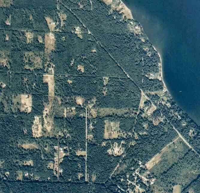
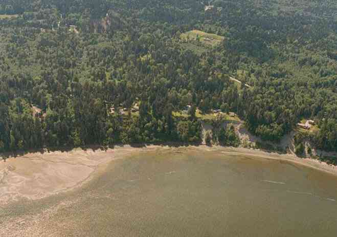
The above September 1997 aerial photo of this section of Camano is from http://www.islandcounty.net/publicworks/digitalphotos/mainmap.htm
The above September 1997 aerial photo of this section of Camano is from
http://www.islandcounty.net/publicworks/digitalphotos/mainmap.htm
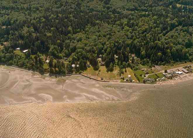
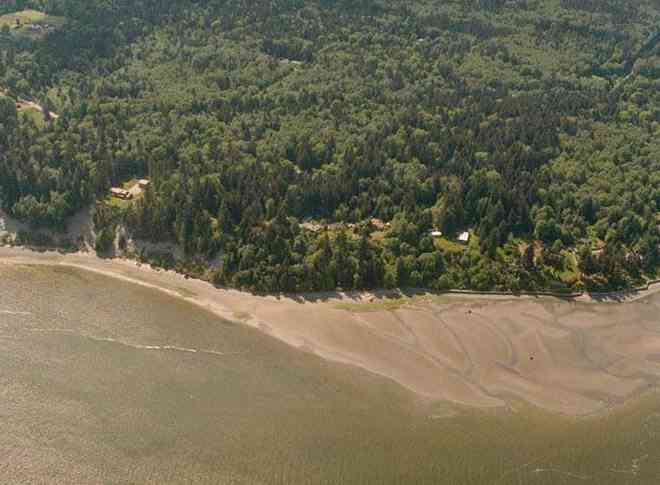
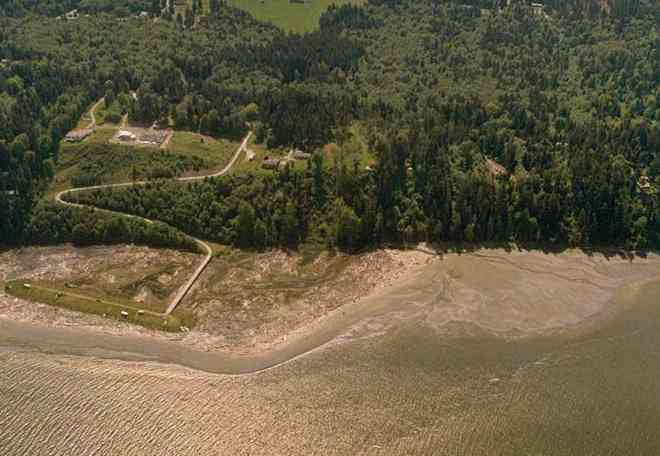
The below 5/11/1993 2:42:00 PM aerial photos are from:
http://apps.ecy.wa.gov/shorephotos
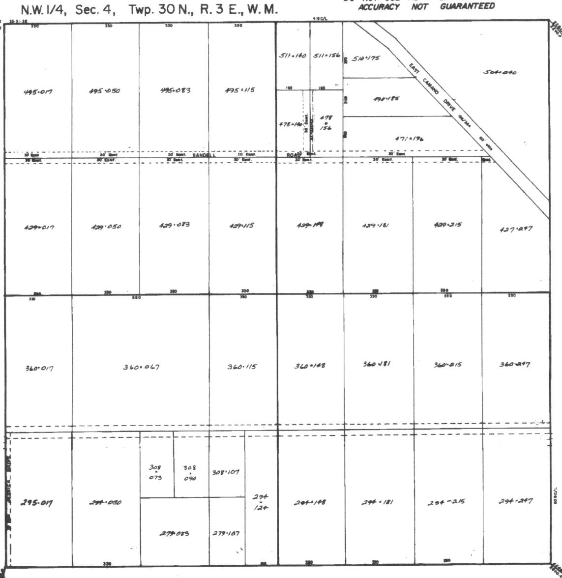
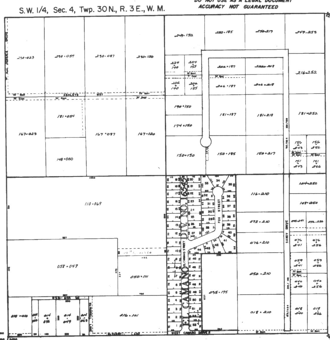
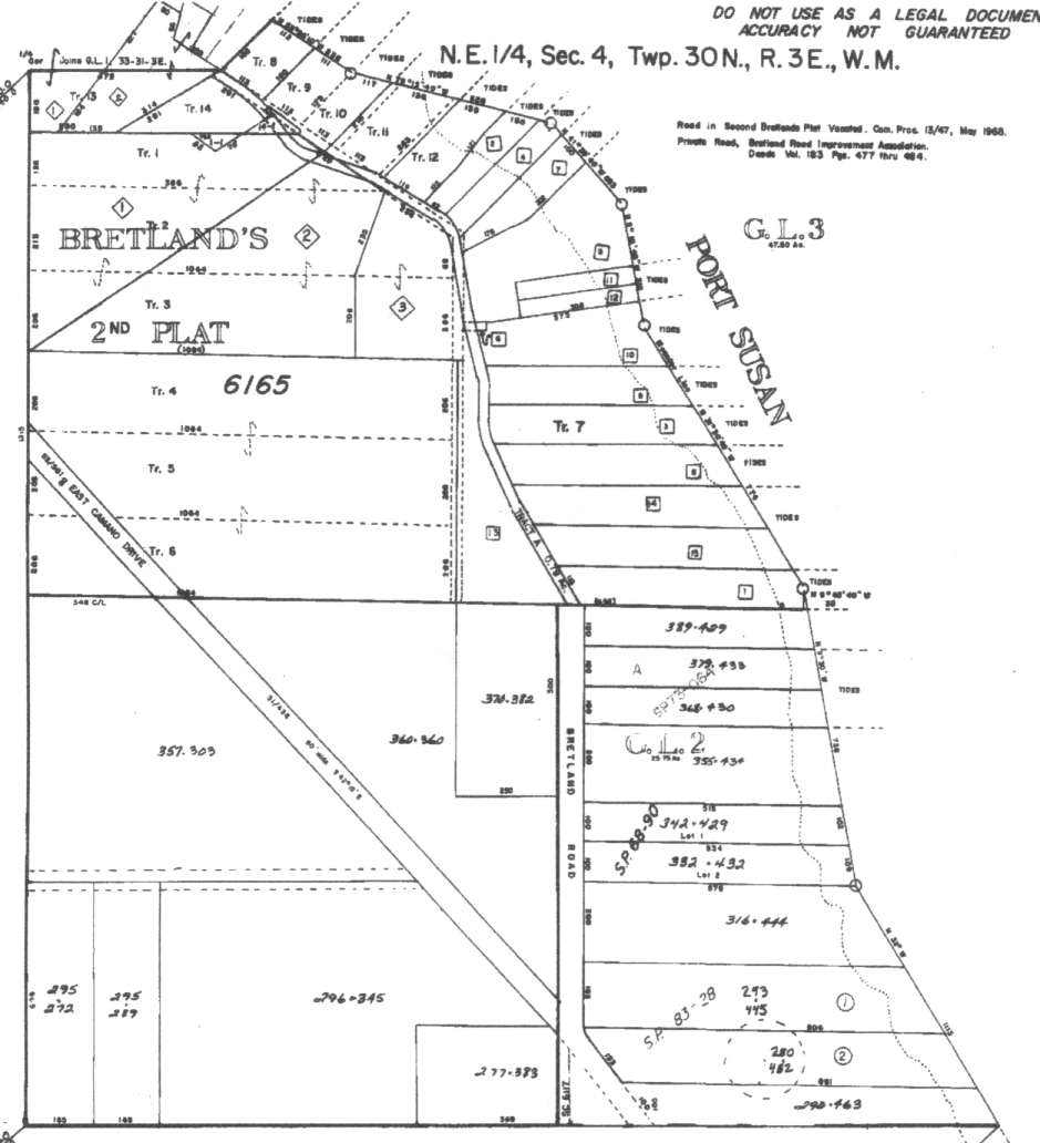
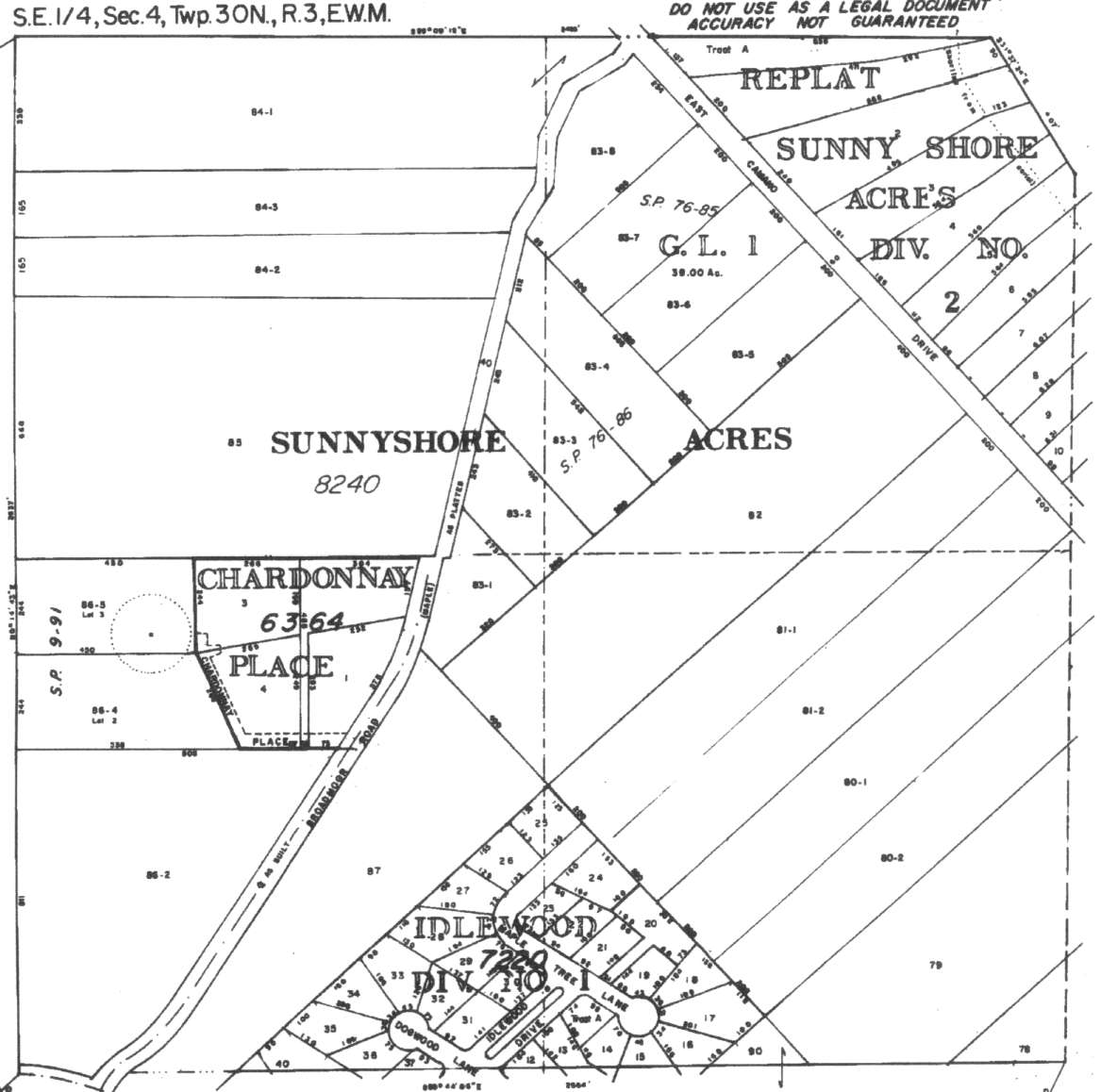
A square system of surveying was ordained by the Continental Congress on May 20, 1785. Within each township (6 miles X 6 miles), are 36 sections. Each section of 640 acres is one mile square (5,280 feet X 5,280 feet). Each quarter section is 160 acres (2,640 feet X 2,640 feet). Most long straight roads and acreage pieces of property have north-south, east-west property lines.
Click on the below Camano section map numbers, to go to a page with Camano Island 2005 assessor data, 1/4 section parcel maps, and aerial photos.
Below are the 63 well reports for this section of Camano, from the December 2004 Washington State Department of Ecology Well log website. Included below is who the well was drilled for, the well depth, and when the well was drilled. At the well log website,
http://apps.ecy.wa.gov/welllog/ more detailed information is available, like the well drillers name, water temperature(sometimes), and soil profile depths.
The below well logs information is from the Washington State Department of Ecology Well log website.
http://apps.ecy.wa.gov/welllog/
 <888>
<888>

1. GEOFF SHOOKĀ - { view PDF
Ā|Ā view TIFF
}
Public Land Survey: NW, NW, S-04, T-30-N, R-03-E, Tax Parcel Number: R33004-429-0170
County: ISLAND, Well Address: XXX SANDELL RD, CAMANO ISLAND, 98282
Well Log ID: 356178, Well Tag ID: ABO931, Notice of Intent Number: W153716
Well Diameter: 6 (inches), Well Depth: 207 (feet)
Well Type: Water, Well Completion Date: 2/15/2003, Well Log Received Date: 3/25/2003
2. ROBERT LINTĀ - { view PDF
Ā|Ā view TIFF
}
Public Land Survey: SW, SW, S-04, T-30-N, R-03-E, Tax Parcel Number: R33004-308-1070
County: ISLAND, Well Address: 850 HAVEN PL, CAMANO ISLAND, 98282
Well Log ID: 352635, Well Tag ID: AGN434, Notice of Intent Number: W159873
Well Diameter: 6 (inches), Well Depth: 286 (feet)
Well Type: Water, Well Completion Date: 1/22/2003, Well Log Received Date: 1/29/2003
3. JOHN BIDWELLĀ - { view PDF
Ā|Ā view TIFF
}
Public Land Survey: SE, NE, S-04, T-30-N, R-03-E, Tax Parcel Number: 33004-293-4450
County: ISLAND, Well Address: 2575 BRETLAND, CAMANO ISLAND
Well Log ID: 339251, Well Tag ID: AGL176, Notice of Intent Number: W147484
Well Diameter: 6 (inches), Well Depth: 219 (feet)
Well Type: Water, Well Completion Date: 8/7/2002, Well Log Received Date: 8/28/2002
4. ROB JAMESĀ - { view PDF
Ā|Ā view TIFF
}
Public Land Survey: NW, NW, S-04, T-30-N, R-03-E, Tax Parcel Number: (blank)
County: ISLAND, Well Address: 2422 SE CAMANO ISLAND 98282
Well Log ID: 338688, Well Tag ID: AGF404, Notice of Intent Number: W156064
Well Diameter: 6 (inches), Well Depth: 220 (feet)
Well Type: Water, Well Completion Date: 6/27/2002, Well Log Received Date: 8/22/2002
5. PAUL BOORMANĀ - { view PDF
Ā|Ā view TIFF
}
Public Land Survey: NW, NE, S-04, T-30-N, R-03-E, Tax Parcel Number: 56165-00-07010-0
County: ISLAND, Well Address: BRETLAND, CAMANO ISLAND
Well Log ID: 314559, Well Tag ID: ABO394, Notice of Intent Number: W156155
Well Diameter: 6 (inches), Well Depth: 138.8 (feet)
Well Type: Water, Well Completion Date: 11/28/2001, Well Log Received Date: 12/13/2001
6. JOHN DRYSDALEĀ - { view PDF
Ā|Ā view TIFF
}
Public Land Survey: SW, NE, S-04, T-30-N, R-03-E, Tax Parcel Number: (blank)
County: ISLAND, Well Address: 2598 BROADMOOR RD, CAMANO ISLAND
Well Log ID: 304099, Well Tag ID: AEF947, Notice of Intent Number: W120915
Well Diameter: 6 (inches), Well Depth: 249 (feet)
Well Type: Water, Well Completion Date: 2/24/2001, Well Log Received Date: 2/27/2001
7. JIM HOWARDĀ - { view PDF
Ā|Ā view TIFF
}
Public Land Survey: NE, SE, S-04, T-30-N, R-03-E, Tax Parcel Number: (blank)
County: ISLAND, Well Address: 2663 SE. CAMANO DRIVE
Well Log ID: 248116, Well Tag ID: AEP771, Notice of Intent Number: W125531
Well Diameter: 6 (inches), Well Depth: 219 (feet)
Well Type: Water, Well Completion Date: 5/16/2000, Well Log Received Date: 6/15/2000
8. ARTHUR BUZZELLEĀ - { view PDF
Ā|Ā view TIFF
}
Public Land Survey: SW, NW, S-04, T-30-N, R-03-E, Tax Parcel Number: (blank)
County: ISLAND, Well Address: 834 HAVEN PLACE, CAMANO ISLAND
Well Log ID: 248115, Well Tag ID: AFF290, Notice of Intent Number: W116540
Well Diameter: 6 (inches), Well Depth: 288 (feet)
Well Type: Water, Well Completion Date: 5/4/2000, Well Log Received Date: 5/15/2000
9. REUBEN CORTEZ / CLAIRE MYERSĀ - { view PDF
Ā|Ā view TIFF
}
Public Land Survey: SE, SW, S-04, T-30-N, R-03-E, Tax Parcel Number: (blank)
County: ISLAND, Well Address: 3053 S. CAMANO DRIVE, CAMANO ISLAND
Well Log ID: 248118, Well Tag ID: AFF289, Notice of Intent Number: W116538
Well Diameter: 6 (inches), Well Depth: 200 (feet)
Well Type: Water, Well Completion Date: 5/1/2000, Well Log Received Date: 5/15/2000
10. James DunlapĀ - { view PDF
Ā|Ā view TIFF
}
Public Land Survey: SW, NW, S-04, T-30-N, R-03-E, Tax Parcel Number: (blank)
County: ISLAND, Well Address: 2555 S HAVEN PLACE, CAMANO ISLAND
Well Log ID: 329548, Well Tag ID: AFJ462, Notice of Intent Number: W039412
Well Diameter: 6 (inches), Well Depth: 258 (feet)
Well Type: Water, Well Completion Date: 4/26/2000, Well Log Received Date: 4/4/2002
11. SALLY TODD KINNEY TRUSTĀ - { view PDF
Ā|Ā view TIFF
}
Public Land Survey: NW, NW, S-04, T-30-N, R-03-E, Tax Parcel Number: (blank)
County: ISLAND, Well Address: LOT 8 BRETLAND RD, CAMANO ISLAND
Well Log ID: 335099, Well Tag ID: AFA672, Notice of Intent Number: W118435
Well Diameter: 6 (inches), Well Depth: 178.5 (feet)
Well Type: Water, Well Completion Date: 11/24/1999, Well Log Received Date: 12/30/1999
12. DARRYL JONESĀ - { view PDF
Ā|Ā view TIFF
}
Public Land Survey: SE, NW, S-04, T-30-N, R-03-E, Tax Parcel Number: (blank)
County: ISLAND, Well Address: SANDY LN
Well Log ID: 190066, Well Tag ID: ABD010, Notice of Intent Number: W075075
Well Diameter: 6 (inches), Well Depth: 240 (feet)
Well Type: Water, Well Completion Date: 6/12/1999, Well Log Received Date: 6/29/1999
13. ROGER WESTERDAHLĀ - { view PDF
Ā|Ā view TIFF
}
Public Land Survey: NW, NW, S-04, T-30-N, R-03-E, Tax Parcel Number: (blank)
County: ISLAND, Well Address: (blank)
Well Log ID: 123100, Well Tag ID: AEG547, Notice of Intent Number: W100796
Well Diameter: 6 (inches), Well Depth: 159 (feet)
Well Type: Water, Well Completion Date: 5/12/1999, Well Log Received Date: 5/18/1999
14. ROBERT DRAKEĀ - { view PDF
Ā|Ā view TIFF
}
Public Land Survey: SW, NE, S-04, T-30-N, R-03-E, Tax Parcel Number: (blank)
County: ISLAND, Well Address: 2620 BROADMOOR
Well Log ID: 87716, Well Tag ID: AER202, Notice of Intent Number: W104050
Well Diameter: 6 (inches), Well Depth: 238 (feet)
Well Type: Water, Well Completion Date: 2/12/1999, Well Log Received Date: 3/2/1999
15. WARREN & GOYLE DENT.Ā - { view PDF
Ā|Ā view TIFF
}
Public Land Survey: SE, SW, S-04, T-30-N, R-03-E, Tax Parcel Number: (blank)
County: ISLAND, Well Address: 3024 S CAMANO DR, CAMANO ISLAND
Well Log ID: 86421, Well Tag ID: ABC746, Notice of Intent Number: W075061
Well Diameter: 6 (inches), Well Depth: 160 (feet)
Well Type: Water, Well Completion Date: 12/9/1998, Well Log Received Date: 1/5/1999
16. PEPPE & FELICIA LOWEĀ - { view PDF
Ā|Ā view TIFF
}
Public Land Survey: NW, NW, S-04, T-30-N, R-03-E, Tax Parcel Number: (blank)
County: ISLAND, Well Address: 958 HAVEN PL, CAMANO ISLAND
Well Log ID: 87458, Well Tag ID: ACY738, Notice of Intent Number: W104158
Well Diameter: 6 (inches), Well Depth: 278 (feet)
Well Type: Water, Well Completion Date: 11/22/1998, Well Log Received Date: 11/25/1998
17. JEFFREY BORRYĀ - { view PDF
Ā|Ā view TIFF
}
Public Land Survey: SE, SE, S-04, T-30-N, R-03-E, Tax Parcel Number: (blank)
County: ISLAND, Well Address: 2688 SE CAMANO DR
Well Log ID: 87251, Well Tag ID: ACQ059, Notice of Intent Number: W107911
Well Diameter: 6 (inches), Well Depth: 241 (feet)
Well Type: Water, Well Completion Date: 11/19/1998, Well Log Received Date: 12/2/1998
18. CARL RECTORĀ - { view PDF
Ā|Ā view TIFF
}
Public Land Survey: NE, SW, S-04, T-30-N, R-03-E, Tax Parcel Number: (blank)
County: ISLAND, Well Address: 2541 SANDY DR, CAMANO ISLAND, 98292
Well Log ID: 87422, Well Tag ID: ACY320, Notice of Intent Number: W099120
Well Diameter: 6 (inches), Well Depth: 215 (feet)
Well Type: Water, Well Completion Date: 8/12/1998, Well Log Received Date: 9/14/1998
19. BOB DE YOUNGĀ - { view PDF
Ā|Ā view TIFF
}
Public Land Survey: NE, NE, S-04, T-30-N, R-03-E, Tax Parcel Number: (blank)
County: ISLAND, Well Address: SANDELL RD
Well Log ID: 87474, Well Tag ID: AEB971, Notice of Intent Number: W093312
Well Diameter: 6 (inches), Well Depth: 215 (feet)
Well Type: Water, Well Completion Date: 7/10/1998, Well Log Received Date: 7/14/1998
20. CATHERINE CASSIDYĀ - { view PDF
Ā|Ā view TIFF
}
Public Land Survey: SE, SW, S-04, T-30-N, R-03-E, Tax Parcel Number: (blank)
County: ISLAND, Well Address: 2748 SANDY DR, CAMANO ISLAND, 98292
Well Log ID: 87539, Well Tag ID: AEF852, Notice of Intent Number: W094510
Well Diameter: 6 (inches), Well Depth: 203 (feet)
Well Type: Water, Well Completion Date: 6/7/1998, Well Log Received Date: 7/7/1998
21. ERIC MUELLERĀ - { view PDF
Ā|Ā view TIFF
}
Public Land Survey: NW, NW, S-04, T-30-N, R-03-E, Tax Parcel Number: (blank)
County: ISLAND, Well Address: 2887 SW CAMANO DR, CAMANO ISLAND
Well Log ID: 86409, Well Tag ID: ABC728, Notice of Intent Number: W075091
Well Diameter: 6 (inches), Well Depth: 206 (feet)
Well Type: Water, Well Completion Date: 5/26/1998, Well Log Received Date: 6/1/1998
22. PAUL ISSACSONĀ - { view PDF
Ā|Ā view TIFF
}
Public Land Survey: NW, SE, S-04, T-30-N, R-03-E, Tax Parcel Number: (blank)
County: ISLAND, Well Address: BROADMORE RD AND CAMANO ISLAND, CAMANO ISLAND
Well Log ID: 82792, Well Tag ID: (blank) , Notice of Intent Number: 101063
Well Diameter: 6 (inches), Well Depth: 250 (feet)
Well Type: Water, Well Completion Date: 4/27/1998, Well Log Received Date: 5/28/1998
23. CUNNINGHAMĀ - { view PDF
Ā|Ā view TIFF
}
Public Land Survey: NW, SE, S-04, T-30-N, R-03-E, Tax Parcel Number: (blank)
County: ISLAND, Well Address: E CAMANO DR, CAMANO ISLAND
Well Log ID: 76141, Well Tag ID: (blank) , Notice of Intent Number: W075079
Well Diameter: 6 (inches), Well Depth: 240 (feet)
Well Type: Water, Well Completion Date: 10/28/1997, Well Log Received Date: 1/8/1998
24. JOHN LEBLANCĀ - { view PDF
Ā|Ā view TIFF
}
Public Land Survey: NE, SW, S-04, T-30-N, R-03-E, Tax Parcel Number: (blank)
County: ISLAND, Well Address: 2657 SANDY DR, CAMANO ISLAND, 98292
Well Log ID: 80210, Well Tag ID: (blank) , Notice of Intent Number: W074170
Well Diameter: 6 (inches), Well Depth: 222 (feet)
Well Type: Water, Well Completion Date: 10/24/1997, Well Log Received Date: 12/8/1997
25. KEITH CHRISTIANĀ - { view PDF
Ā|Ā view TIFF
}
Public Land Survey: NE, SW, S-04, T-30-N, R-03-E, Tax Parcel Number: (blank)
County: ISLAND, Well Address: 2621 SANDY DR, CAMANO ISLAND, 98292
Well Log ID: 80586, Well Tag ID: (blank) , Notice of Intent Number: W073064
Well Diameter: 6 (inches), Well Depth: 260 (feet)
Well Type: Water, Well Completion Date: 7/7/1997, Well Log Received Date: (blank)
26. RON COSTER / CORLISS CRAIGĀ - { view PDF
Ā|Ā view TIFF
}
Public Land Survey: SW, SW, S-04, T-30-N, R-03-E, Tax Parcel Number: (blank)
County: ISLAND, Well Address: 865 E W CAMANO DR
Well Log ID: 83984, Well Tag ID: (blank) , Notice of Intent Number: W063545
Well Diameter: 6 (inches), Well Depth: 198 (feet)
Well Type: Water, Well Completion Date: 1/7/1997, Well Log Received Date: 1/16/1997
27. NORMAN & ELLEEN CREETHĀ - { view PDF
Ā|Ā view TIFF
}
Public Land Survey: NE, NW, S-04, T-30-N, R-03-E, Tax Parcel Number: (blank)
County: ISLAND, Well Address: SONDELL RD, CAMANO ISLAND
Well Log ID: 82535, Well Tag ID: (blank) , Notice of Intent Number: W073056
Well Diameter: 6 (inches), Well Depth: 240 (feet)
Well Type: Water, Well Completion Date: 10/30/1996, Well Log Received Date: 11/1/1996
28. RAINER L.T.D.Ā - { view PDF
Ā|Ā view TIFF
}
Public Land Survey: NW, SW, S-04, T-30-N, R-03-E, Tax Parcel Number: (blank)
County: ISLAND, Well Address: 883 ASHLEYS WY, CAMANO ISLAND
Well Log ID: 83141, Well Tag ID: (blank) , Notice of Intent Number: W073054
Well Diameter: 6 (inches), Well Depth: 260 (feet)
Well Type: Water, Well Completion Date: 10/17/1996, Well Log Received Date: 11/1/1996
29. JAMES VIRGINIA WATSONĀ - { view PDF
Ā|Ā view TIFF
}
Public Land Survey: SE, NE, S-04, T-30-N, R-03-E, Tax Parcel Number: (blank)
County: ISLAND, Well Address: 25615 S BRETLUND RD, CAMANO ISLAND, 98292
Well Log ID: 79360, Well Tag ID: (blank) , Notice of Intent Number: W064581
Well Diameter: 6 (inches), Well Depth: 220 (feet)
Well Type: Water, Well Completion Date: 7/1/1996, Well Log Received Date: 7/18/1996
30. CINDY WRIGHTĀ - { view PDF
Ā|Ā view TIFF
}
Public Land Survey: NW, NE, S-04, T-30-N, R-03-E, Tax Parcel Number: (blank)
County: ISLAND, Well Address: 2555 RD, CAMANO ISLAND, 98292
Well Log ID: 75903, Well Tag ID: (blank) , Notice of Intent Number: W054356
Well Diameter: 6 (inches), Well Depth: 260 (feet)
Well Type: Water, Well Completion Date: 6/14/1996, Well Log Received Date: 7/16/1996
31. PHILL FREEMANĀ - { view PDF
Ā|Ā view TIFF
}
Public Land Survey: NW, SW, S-04, T-30-N, R-03-E, Tax Parcel Number: (blank)
County: ISLAND, Well Address: JESSICA LN, CAMANO ISLAND
Well Log ID: 87749, Well Tag ID: (blank) , Notice of Intent Number: W064420
Well Diameter: 6 (inches), Well Depth: 280 (feet)
Well Type: Water, Well Completion Date: 3/26/1996, Well Log Received Date: 4/10/1996
32. MIKE ROSENBECH - KENSEDYĀ - { view PDF
Ā|Ā view TIFF
}
Public Land Survey: SW, SW, S-04, T-30-N, R-03-E, Tax Parcel Number: (blank)
County: ISLAND, Well Address: 823 E W CAMANO ISLAND DR, CAMANO ISLAND, 98292
Well Log ID: 82146, Well Tag ID: (blank) , Notice of Intent Number: W063332
Well Diameter: 6 (inches), Well Depth: 241 (feet)
Well Type: Water, Well Completion Date: 7/10/1995, Well Log Received Date: 8/28/1995
33. KENNETH KRAEMERĀ - { view PDF
Ā|Ā view TIFF
}
Public Land Survey: NW, NW, S-04, T-30-N, R-03-E, Tax Parcel Number: (blank)
County: ISLAND, Well Address: 928 E 2555 S, CAMANO ISLAND, 98292
Well Log ID: 80749, Well Tag ID: (blank) , Notice of Intent Number: (blank)
Well Diameter: 6 (inches), Well Depth: 237 (feet)
Well Type: Water, Well Completion Date: 3/24/1995, Well Log Received Date: 4/12/1995
34. DENNIS CONNER / DAR ST. CLAIRĀ - { view PDF
Ā|Ā view TIFF
}
Public Land Survey: NW, SE, S-04, T-30-N, R-03-E, Tax Parcel Number: (blank)
County: ISLAND, Well Address: CEDARWOOD CT
Well Log ID: 86829, Well Tag ID: ABN980, Notice of Intent Number: W020485
Well Diameter: 6 (inches), Well Depth: 278 (feet)
Well Type: Water, Well Completion Date: 11/8/1994, Well Log Received Date: 11/14/1994
35. DON BRUNESĀ - { view PDF
Ā|Ā view TIFF
}
Public Land Survey: NW, NW, S-04, T-30-N, R-03-E, Tax Parcel Number: (blank)
County: ISLAND, Well Address: SANDELL RD, CAMANO ISLAND, 98292
Well Log ID: 77052, Well Tag ID: (blank) , Notice of Intent Number: W043154
Well Diameter: 6 (inches), Well Depth: 238 (feet)
Well Type: Water, Well Completion Date: 3/24/1994, Well Log Received Date: 5/16/1994
36. A. H. VANBREUKELENĀ - { view PDF
Ā|Ā view TIFF
}
Public Land Survey: NW, NW, S-04, T-30-N, R-03-E, Tax Parcel Number: (blank)
County: ISLAND, Well Address: 959 E SANDELL RD, CAMANO ISLAND, 98292
Well Log ID: 74153, Well Tag ID: (blank) , Notice of Intent Number: W043556
Well Diameter: 6 (inches), Well Depth: 225 (feet)
Well Type: Water, Well Completion Date: 12/27/1993, Well Log Received Date: 3/18/1994
37. JOSEPH DRISCOLLĀ - { view PDF
Ā|Ā view TIFF
}
Public Land Survey: (blank), NW, S-04, T-30-N, R-03-E, Tax Parcel Number: (blank)
County: ISLAND, Well Address: E CAMANO AND S 2555 RD, CAMANO ISLAND
Well Log ID: 80429, Well Tag ID: (blank) , Notice of Intent Number: W010547
Well Diameter: 6 (inches), Well Depth: 240 (feet)
Well Type: Water, Well Completion Date: 9/3/1993, Well Log Received Date: 11/12/1993
38. HAL RATHVONĀ - { view PDF
Ā|Ā view TIFF
}
Public Land Survey: NW, NE, S-04, T-30-N, R-03-E, Tax Parcel Number: (blank)
County: ISLAND, Well Address: 2507 S BRETLAND RD, CAMANO ISLAND, 98292
Well Log ID: 78736, Well Tag ID: (blank) , Notice of Intent Number: 200483
Well Diameter: 6 (inches), Well Depth: 180 (feet)
Well Type: Water, Well Completion Date: 7/1/1993, Well Log Received Date: 7/15/1993
39. E. ROSS PARKSĀ - { view PDF
Ā|Ā view TIFF
}
Public Land Survey: SE, NE, S-04, T-30-N, R-03-E, Tax Parcel Number: (blank)
County: ISLAND, Well Address: 26915 SANDY DR, CAMANO ISLAND, 98292
Well Log ID: 77435, Well Tag ID: (blank) , Notice of Intent Number: 070888
Well Diameter: 6 (inches), Well Depth: 260 (feet)
Well Type: Water, Well Completion Date: 6/17/1993, Well Log Received Date: 6/18/1993
40. R. FARRELLĀ - { view PDF
Ā|Ā view TIFF
}
Public Land Survey: SE, SW, S-04, T-30-N, R-03-E, Tax Parcel Number: (blank)
County: ISLAND, Well Address: ELGAMANO ST
Well Log ID: 291810, Well Tag ID: (blank) , Notice of Intent Number: 047232
Well Diameter: 6 (inches), Well Depth: 250 (feet)
Well Type: Water, Well Completion Date: 5/20/1993, Well Log Received Date: (blank)
41. N .TUTLISĀ - { view PDF
Ā|Ā view TIFF
}
Public Land Survey: SE, SW, S-04, T-30-N, R-03-E, Tax Parcel Number: (blank)
County: ISLAND, Well Address: SANDY DR, CAMANO ISLAND
Well Log ID: 82396, Well Tag ID: (blank) , Notice of Intent Number: (blank)
Well Diameter: 6 (inches), Well Depth: 200 (feet)
Well Type: Water, Well Completion Date: 9/10/1992, Well Log Received Date: 9/28/1992
42. MIKE GILLIGANĀ - { view PDF
Ā|Ā view TIFF
}
Public Land Survey: NE, SW, S-04, T-30-N, R-03-E, Tax Parcel Number: (blank)
County: ISLAND, Well Address: 2625 SANDY DR, CAMANO ISLAND, 98292
Well Log ID: 82063, Well Tag ID: (blank) , Notice of Intent Number: (blank)
Well Diameter: 6 (inches), Well Depth: 280 (feet)
Well Type: Water, Well Completion Date: 6/24/1992, Well Log Received Date: 7/17/1992
43. RON COSTER, CRAIG CORLISS, CHARLES RUSSELLĀ - { view PDF
Ā|Ā view TIFF
}
Public Land Survey: SW, SE, S-04, T-30-N, R-03-E, Tax Parcel Number: 58240-00-00086-5
County: ISLAND, Well Address: CHARDONNAY PL
Well Log ID: 376462, Well Tag ID: AKY720, Notice of Intent Number: (blank)
Well Diameter: 6 (inches), Well Depth: 255 (feet)
Well Type: Water, Well Completion Date: 6/10/1992, Well Log Received Date: (blank)
44. WAYNE MC NICOLESĀ - { view PDF
Ā|Ā view TIFF
}
Public Land Survey: NW, NW, S-04, T-30-N, R-03-E, Tax Parcel Number: (blank)
County: ISLAND, Well Address: 1000 SANDLE RD, CAMANO ISLAND
Well Log ID: 85789, Well Tag ID: (blank) , Notice of Intent Number: (blank)
Well Diameter: (blank) , Well Depth: 223 (feet)
Well Type: Water, Well Completion Date: 6/5/1992, Well Log Received Date: 6/23/1992
45. CHARLES WILFONGĀ - { view PDF
Ā|Ā view TIFF
}
Public Land Survey: SE, NW, S-04, T-30-N, R-03-E, Tax Parcel Number: (blank)
County: ISLAND, Well Address: CAMANO ISLAND, 98292
Well Log ID: 75774, Well Tag ID: (blank) , Notice of Intent Number: 042007
Well Diameter: 6 (inches), Well Depth: 267 (feet)
Well Type: Water, Well Completion Date: 2/5/1992, Well Log Received Date: 2/19/1992
46. JOHN HENNINGĀ - { view PDF
Ā|Ā view TIFF
}
Public Land Survey: NW, SE, S-04, T-30-N, R-03-E, Tax Parcel Number: (blank)
County: ISLAND, Well Address: 850 E 2650 S, CAMANO ISLAND, 98292
Well Log ID: 80159, Well Tag ID: (blank) , Notice of Intent Number: 041866
Well Diameter: 6 (inches), Well Depth: 290 (feet)
Well Type: Water, Well Completion Date: 10/3/1991, Well Log Received Date: (blank)
47. JOHN HEMNINYĀ - { view PDF
Ā|Ā view TIFF
}
Public Land Survey: NW, SE, S-04, T-30-N, R-03-E, Tax Parcel Number: (blank)
County: ISLAND, Well Address: 850E 26505, CAMANO IS
Well Log ID: 291540, Well Tag ID: (blank) , Notice of Intent Number: 041866
Well Diameter: 6 (inches), Well Depth: 290 (feet)
Well Type: Water, Well Completion Date: 10/3/1991, Well Log Received Date: (blank)
48. DON BAKERĀ - { view PDF
Ā|Ā view TIFF
}
Public Land Survey: SW, NW, S-04, T-30-N, R-03-E, Tax Parcel Number: (blank)
County: ISLAND, Well Address: CAMANO ISLAND, 98292
Well Log ID: 77038, Well Tag ID: (blank) , Notice of Intent Number: 040873
Well Diameter: 6 (inches), Well Depth: 293 (feet)
Well Type: Water, Well Completion Date: 8/3/1991, Well Log Received Date: 8/23/1991
49. MARIS PETERSONSĀ - { view PDF
Ā|Ā view TIFF
}
Public Land Survey: NE, SW, S-04, T-30-N, R-03-E, Tax Parcel Number: (blank)
County: ISLAND, Well Address: 2650 S SANDY DR, CAMANO ISLAND
Well Log ID: 81585, Well Tag ID: (blank) , Notice of Intent Number: 070365
Well Diameter: 6 (inches), Well Depth: 257 (feet)
Well Type: Water, Well Completion Date: 10/3/1990, Well Log Received Date: 10/9/1990
50. LEROY DAHLĀ - { view PDF
Ā|Ā view TIFF
}
Public Land Survey: NE, NE, S-04, T-30-N, R-03-E, Tax Parcel Number: (blank)
County: ISLAND, Well Address: BRETLAND RD SE, CAMANO ISLAND, 98292
Well Log ID: 81214, Well Tag ID: (blank) , Notice of Intent Number: 070340
Well Diameter: 6 (inches), Well Depth: 205 (feet)
Well Type: Water, Well Completion Date: 5/11/1990, Well Log Received Date: 8/6/1990
51. JAMES TOEVS & LARSONĀ - { view PDF
Ā|Ā view TIFF
}
Public Land Survey: NW, NW, S-04, T-30-N, R-03-E, Tax Parcel Number: (blank)
County: ISLAND, Well Address: 839 E SANDELL RD, CAMANO ISLAND
Well Log ID: 79356, Well Tag ID: (blank) , Notice of Intent Number: 072413
Well Diameter: 6 (inches), Well Depth: 220 (feet)
Well Type: Water, Well Completion Date: 3/2/1990, Well Log Received Date: 3/27/1990
52. JOHN TUTUSĀ - { view PDF
Ā|Ā view TIFF
}
Public Land Survey: SE, SW, S-04, T-30-N, R-03-E, Tax Parcel Number: (blank)
County: ISLAND, Well Address: (blank)
Well Log ID: 80351, Well Tag ID: (blank) , Notice of Intent Number: (blank)
Well Diameter: 6 (inches), Well Depth: 200 (feet)
Well Type: Water, Well Completion Date: 10/13/1988, Well Log Received Date: (blank)
53. MR. WHALEYĀ - { view PDF
Ā|Ā view TIFF
}
Public Land Survey: NE, NW, S-04, T-30-N, R-03-E, Tax Parcel Number: (blank)
County: ISLAND, Well Address: (blank)
Well Log ID: 82326, Well Tag ID: (blank) , Notice of Intent Number: (blank)
Well Diameter: 6 (inches), Well Depth: 93 (feet)
Well Type: Water, Well Completion Date: 11/30/1987, Well Log Received Date: 12/3/1987
54. M. A. WESTBYĀ - { view PDF
Ā|Ā view TIFF
}
Public Land Survey: SW, NW, S-04, T-30-N, R-03-E, Tax Parcel Number: (blank)
County: ISLAND, Well Address: (blank)
Well Log ID: 81483, Well Tag ID: (blank) , Notice of Intent Number: (blank)
Well Diameter: 6 (inches), Well Depth: 263 (feet)
Well Type: Water, Well Completion Date: 9/15/1985, Well Log Received Date: (blank)
55. JACK HAGENĀ - { view PDF
Ā|Ā view TIFF
}
Public Land Survey: SW, SW, S-04, T-30-N, R-03-E, Tax Parcel Number: (blank)
County: ISLAND, Well Address: (blank)
Well Log ID: 79181, Well Tag ID: (blank) , Notice of Intent Number: (blank)
Well Diameter: 6 (inches), Well Depth: 201 (feet)
Well Type: Water, Well Completion Date: 6/4/1979, Well Log Received Date: (blank)
56. SHAUN KIRBYĀ - { view PDF
Ā|Ā view TIFF
}
Public Land Survey: SE, SW, S-04, T-30-N, R-03-E, Tax Parcel Number: (blank)
County: ISLAND, Well Address: (blank)
Well Log ID: 84472, Well Tag ID: (blank) , Notice of Intent Number: (blank)
Well Diameter: 6 (inches), Well Depth: 162 (feet)
Well Type: Water, Well Completion Date: 2/9/1978, Well Log Received Date: (blank)
57. JAMES PHILLIPSĀ - { view PDF
Ā|Ā view TIFF
}
Public Land Survey: SW, NE, S-04, T-30-N, R-03-E, Tax Parcel Number: (blank)
County: ISLAND, Well Address: (blank)
Well Log ID: 79321, Well Tag ID: (blank) , Notice of Intent Number: (blank)
Well Diameter: 6 (inches), Well Depth: 290 (feet)
Well Type: Water, Well Completion Date: 3/20/1971, Well Log Received Date: (blank)
58. ART COOKĀ - { view PDF
Ā|Ā view TIFF
}
Public Land Survey: SE, SW, S-04, T-30-N, R-03-E, Tax Parcel Number: (blank)
County: ISLAND, Well Address: (blank)
Well Log ID: 351200, Well Tag ID: AGA711, Notice of Intent Number: (blank)
Well Diameter: 6 (inches), Well Depth: 236 (feet)
Well Type: Water, Well Completion Date: 2/18/1970, Well Log Received Date: (blank)
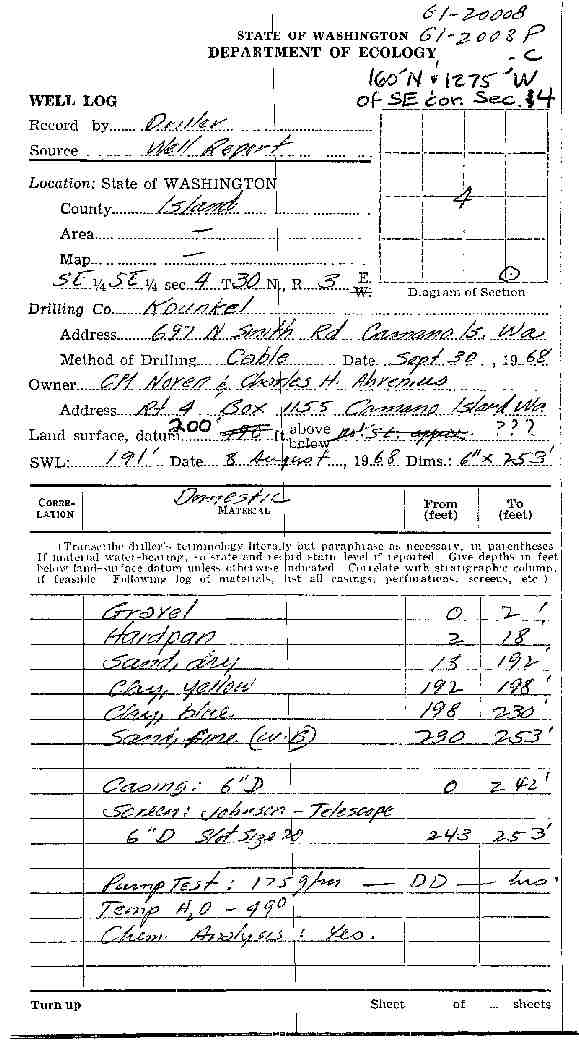
59. C M NOREN & CHARLES H ABRENIUSĀ - { view PDF
Ā|Ā view TIFF
}
Public Land Survey: SE, SE, S-04, T-30-N, R-03-E, Tax Parcel Number: (blank)
County: ISLAND, Well Address: (blank)
Well Log ID: 351080, Well Tag ID: (blank) , Notice of Intent Number: (blank)
Well Diameter: 6 (inches), Well Depth: 253 (feet)
Well Type: Water, Well Completion Date: 9/30/1968, Well Log Received Date: (blank)
60. KENNETH EMERSON DAYĀ - { view PDF
Ā|Ā view TIFF
}
Public Land Survey: SE, SE, S-04, T-30-N, R-03-E, Tax Parcel Number: (blank)
County: ISLAND, Well Address: (blank)
Well Log ID: 80746, Well Tag ID: (blank) , Notice of Intent Number: (blank)
Well Diameter: 36 (inches), Well Depth: 152 (feet)
Well Type: Water, Well Completion Date: (blank) , Well Log Received Date: (blank)
61. LEO STEPHENSĀ - { view PDF
Ā|Ā view TIFF
}
Public Land Survey: SE, NW, S-04, T-30-N, R-03-E, Tax Parcel Number: (blank)
County: ISLAND, Well Address: (blank)
Well Log ID: 285409, Well Tag ID: (blank) , Notice of Intent Number: (blank)
Well Diameter: 6 (inches), Well Depth: 220 (feet)
Well Type: Water, Well Completion Date: (blank) , Well Log Received Date: (blank)
62. ROBERT BRUCE BRETLANDĀ - { view PDF
Ā|Ā view TIFF
}
Public Land Survey: NW, NE, S-04, T-30-N, R-03-E, Tax Parcel Number: (blank)
County: ISLAND, Well Address: (blank)
Well Log ID: 351078, Well Tag ID: (blank) , Notice of Intent Number: (blank)
Well Diameter: 24 (inches), Well Depth: 36 (feet)
Well Type: Water, Well Completion Date: (blank) , Well Log Received Date: (blank)
63. FRANK F HART JRĀ - { view PDF
Ā|Ā view TIFF
}
Public Land Survey: NW, NE, S-04, T-30-N, R-03-E, Tax Parcel Number: (blank)
County: ISLAND, Well Address: (blank)
Well Log ID: 351079, Well Tag ID: (blank) , Notice of Intent Number: (blank)
Well Diameter: 36 (inches), Well Depth: 75 (feet)
Well Type: Water, Well Completion Date: (blank) , Well Log Received Date: (blank)
wr33004sandellshook2003genes
wr33004noren1968kounkel