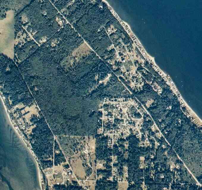
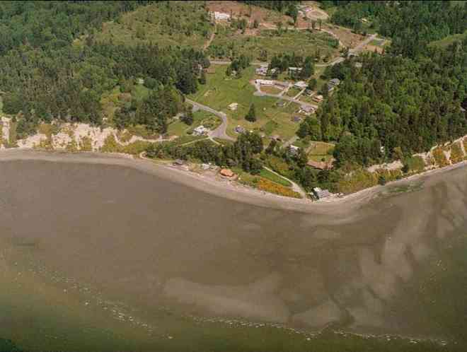
The above September 1997 aerial photo of this section of Camano is from http://www.islandcounty.net/publicworks/digitalphotos/mainmap.htm
The above September 1997 aerial photo of this section of Camano is from
http://www.islandcounty.net/publicworks/digitalphotos/mainmap.htm
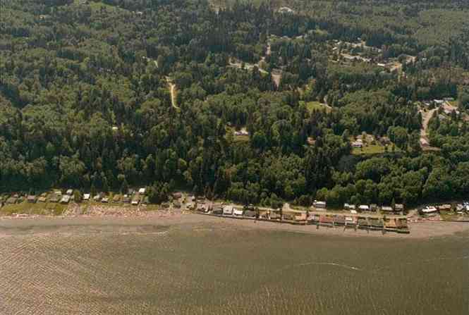
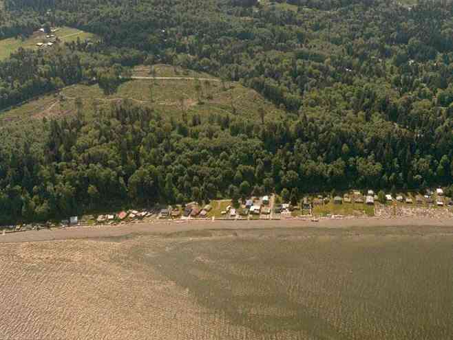
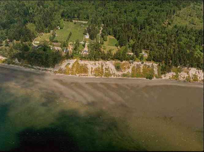
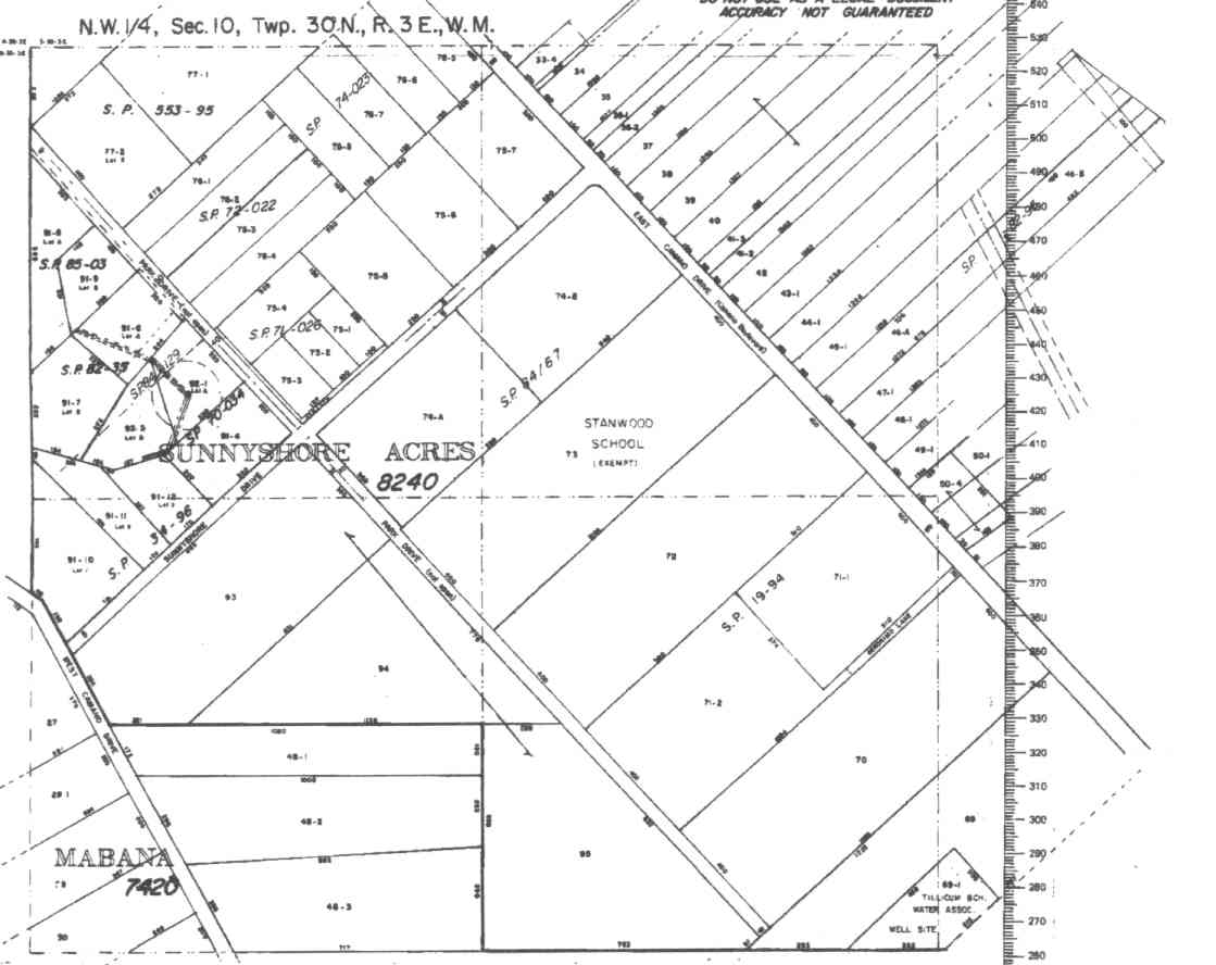
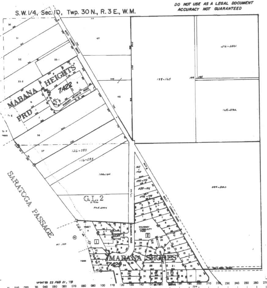
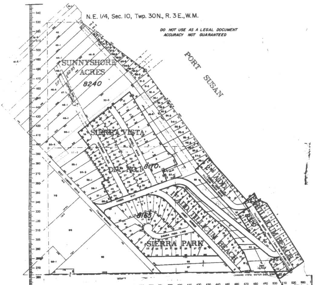
The below 5/11/1993 2:42:00 PM aerial photos are from:
http://apps.ecy.wa.gov/shorephotos
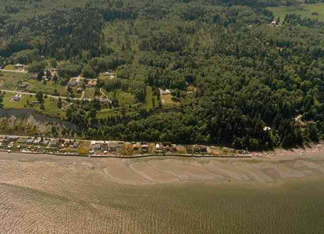
Tillicum Beach, east side of Camano
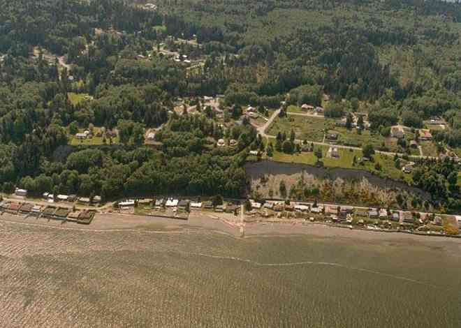
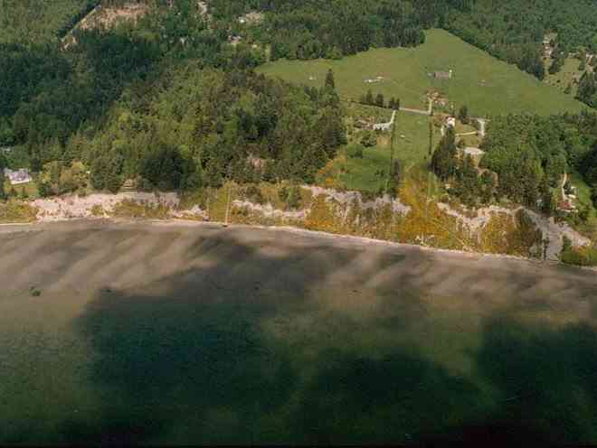
Mabana, west side of Camano
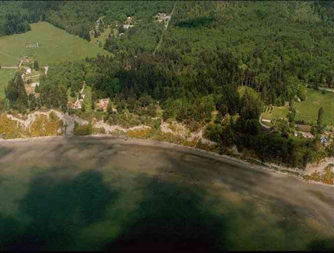
Mabana Shores, west side of Camano
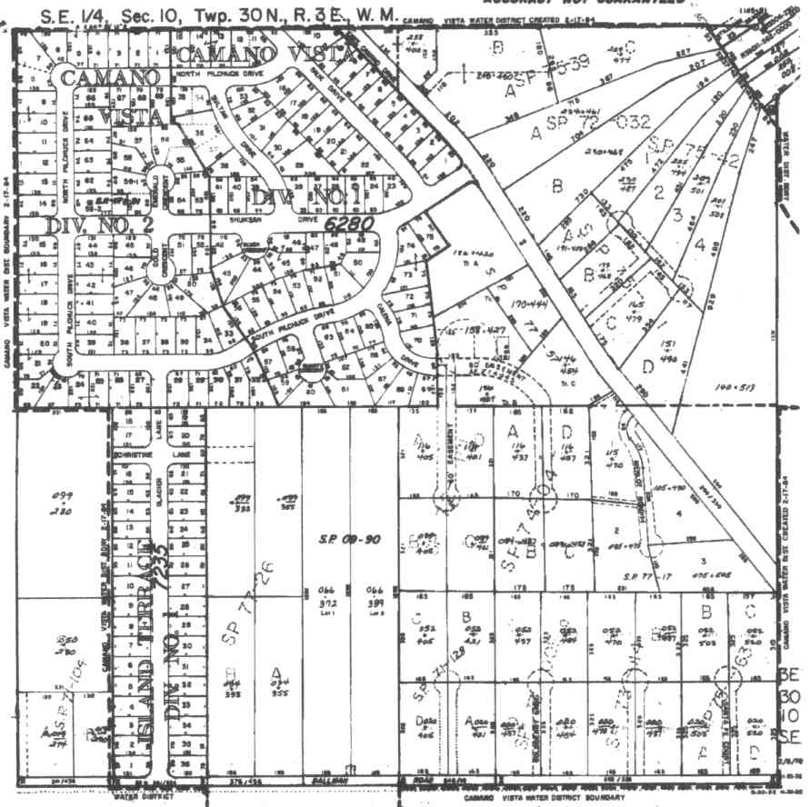
A square system of surveying was ordained by the Continental Congress on May 20, 1785. Within each township (6 miles X 6 miles), are 36 sections. Each section of 640 acres is one mile square (5,280 feet X 5,280 feet). Each quarter section is 160 acres (2,640 feet X 2,640 feet). Most long straight roads and acreage pieces of property have north-south, east-west property lines.
Click on the below Camano section map numbers, to go to a page with Camano Island 2005 assessor data, 1/4 section parcel maps, and aerial photos.
Below are the 46 well reports for this section of Camano, from the December 2004 Washington State Department of Ecology Well log website. Included below is who the well was drilled for, the well depth, and when the well was drilled. At the well log website,
http://apps.ecy.wa.gov/welllog/ more detailed information is available, like the well drillers name, water temperature(sometimes), and soil profile depths.
 <888>
<888>

1. TILLICUM BEACH WATER ASSOCĀ - { view PDF
Ā|Ā view TIFF
}
Public Land Survey: NW, SE, S-10, T-30-N, R-03-E, Tax Parcel Number: (blank)
County: ISLAND, Well Address: (blank)
Well Log ID: 383971, Well Tag ID: ALA605, Notice of Intent Number: W177642
Well Diameter: 6 (inches), Well Depth: 258 (feet)
Well Type: Water, Well Completion Date: 6/30/2004, Well Log Received Date: 7/27/2004
2. TILLICUM BEACH WATER ASSOCĀ - { view PDF
Ā|Ā view TIFF
}
Public Land Survey: NW, SE, S-10, T-30-N, R-03-E, Tax Parcel Number: (blank)
County: ISLAND, Well Address: (blank)
Well Log ID: 383972, Well Tag ID: AHT441, Notice of Intent Number: W177622
Well Diameter: 6 (inches), Well Depth: 243.3 (feet)
Well Type: Water, Well Completion Date: 5/19/2004, Well Log Received Date: 7/27/2004
3. CHARLES INGRAHAM / ELIZABETH THOMASĀ - { view PDF
Ā|Ā view TIFF
}
Public Land Survey: SE, SE, S-10, T-30-N, R-03-E, Tax Parcel Number: 58240-00-00040
County: ISLAND, Well Address: 1365 STEFFEN PL, CAMANO ISLAND 98282
Well Log ID: 372878, Well Tag ID: ABO958, Notice of Intent Number: W153743
Well Diameter: 6 (inches), Well Depth: 176 (feet)
Well Type: Water, Well Completion Date: 10/7/2003, Well Log Received Date: 12/31/2003
4. SUN MOUNTAIN CONSTRUCTIONĀ - { view PDF
Ā|Ā view TIFF
}
Public Land Survey: NE, SE, S-10, T-30-N, R-03-E, Tax Parcel Number: (blank)
County: ISLAND, Well Address: XXX ESSENCE WY, CAMANO ISLAND
Well Log ID: 331850, Well Tag ID: ACY397, Notice of Intent Number: W156056
Well Diameter: 6 (inches), Well Depth: 220 (feet)
Well Type: Water, Well Completion Date: 12/13/2001, Well Log Received Date: 4/18/2002
5. CAMANO VISTA WATER DISTĀ - { view PDF
Ā|Ā view TIFF
}
Public Land Survey: SE, SE, S-10, T-30-N, R-03-E, Tax Parcel Number: (blank)
County: ISLAND, Well Address: XXX COLFAX AVE, CAMANO ISLAND, 98282
Well Log ID: 305286, Well Tag ID: AFJ759, Notice of Intent Number: W098089
Well Diameter: 6 (inches), Well Depth: 197 (feet)
Well Type: Water, Well Completion Date: 10/3/2000, Well Log Received Date: 3/27/2001
6. CHARLES CARMANĀ - { view PDF
Ā|Ā view TIFF
}
Public Land Survey: SE, NW, S-10, T-30-N, R-03-E, Tax Parcel Number: (blank)
County: ISLAND, Well Address: XXX SUNNY SHORE AVE, CAMANO ISLAND
Well Log ID: 304100, Well Tag ID: AFJ756, Notice of Intent Number: W098083
Well Diameter: 6 (inches), Well Depth: 265 (feet)
Well Type: Water, Well Completion Date: 8/25/2000, Well Log Received Date: 11/8/2000
7. MARY HARALSONĀ - { view PDF
Ā|Ā view TIFF
}
Public Land Survey: SW, SW, S-10, T-30-N, R-03-E, Tax Parcel Number: (blank)
County: ISLAND, Well Address: XX W CAMANO DR, CAMANO ISLAND
Well Log ID: 235471, Well Tag ID: AEF895, Notice of Intent Number: W098058
Well Diameter: 6 (inches), Well Depth: 192 (feet)
Well Type: Water, Well Completion Date: 8/26/1999, Well Log Received Date: 10/29/1999
8. JACK DORSEYĀ - { view PDF
Ā|Ā view TIFF
}
Public Land Survey: NW, NW, S-10, T-30-N, R-03-E, Tax Parcel Number: 119AF96019174
County: ISLAND, Well Address: 2772 SE CAMANO DR, CAMANO ISLAND
Well Log ID: 86423, Well Tag ID: ABC748, Notice of Intent Number: W075064
Well Diameter: 6 (inches), Well Depth: 263 (feet)
Well Type: Water, Well Completion Date: 1/18/1999, Well Log Received Date: 2/10/1999
9. ORAN JONESĀ - { view PDF
Ā|Ā view TIFF
}
Public Land Survey: NW, NE, S-10, T-30-N, R-03-E, Tax Parcel Number: (blank)
County: ISLAND, Well Address: (blank)
Well Log ID: 82652, Well Tag ID: (blank) , Notice of Intent Number: W073046
Well Diameter: 6 (inches), Well Depth: 280 (feet)
Well Type: Water, Well Completion Date: 2/19/1997, Well Log Received Date: 2/24/1997
10. Sierra Vista AssocĀ - { view PDF
Ā|Ā view TIFF
}
Public Land Survey: SW, NE, S-10, T-30-N, R-03-E, Tax Parcel Number: 3-8240-00-00047-1
County: ISLAND, Well Address: (blank)
Well Log ID: 84528, Well Tag ID: AAF240, Notice of Intent Number: W009073
Well Diameter: 6 (inches), Well Depth: 278 (feet)
Well Type: Water, Well Completion Date: 3/13/1996, Well Log Received Date: 3/21/1996
11. ROGER NELSONĀ - { view PDF
Ā|Ā view TIFF
}
Public Land Survey: NW, NW, S-10, T-30-N, R-03-E, Tax Parcel Number: (blank)
County: ISLAND, Well Address: 2801 S PARK DR, CAMANO ISLAND
Well Log ID: 83927, Well Tag ID: (blank) , Notice of Intent Number: W054345
Well Diameter: 6 (inches), Well Depth: 220 (feet)
Well Type: Water, Well Completion Date: 10/3/1995, Well Log Received Date: 10/10/1995
12. JOHN & WILLA O'CONNERĀ - { view PDF
Ā|Ā view TIFF
}
Public Land Survey: SW, SW, S-10, T-30-N, R-03-E, Tax Parcel Number: (blank)
County: ISLAND, Well Address: S CAMANO AND REDWING, CAMANO ISLAND
Well Log ID: 80043, Well Tag ID: (blank) , Notice of Intent Number: W003127
Well Diameter: 6 (inches), Well Depth: 151 (feet)
Well Type: Water, Well Completion Date: 5/9/1994, Well Log Received Date: 5/19/1994
13. JOHN & WILLA O'CONNERĀ - { view PDF
Ā|Ā view TIFF
}
Public Land Survey: SW, SW, S-10, T-30-N, R-03-E, Tax Parcel Number: (blank)
County: ISLAND, Well Address: S CAMANO AND REDWING, CAMANO ISLAND
Well Log ID: 80044, Well Tag ID: (blank) , Notice of Intent Number: W003125
Well Diameter: 6 (inches), Well Depth: 194 (feet)
Well Type: Water, Well Completion Date: 5/10/1994, Well Log Received Date: 5/19/1994
14. RON KOCHĀ - { view PDF
Ā|Ā view TIFF
}
Public Land Survey: NE, NW, S-10, T-30-N, R-03-E, Tax Parcel Number: (blank)
County: ISLAND, Well Address: E CAMANO DR
Well Log ID: 86525, Well Tag ID: ABD903, Notice of Intent Number: W010468
Well Diameter: 6 (inches), Well Depth: 280 (feet)
Well Type: Water, Well Completion Date: 9/30/1993, Well Log Received Date: 10/5/1993
15. MABANA SHORESĀ - { view PDF
Ā|Ā view TIFF
}
Public Land Survey: SE, SW, S-10, T-30-N, R-03-E, Tax Parcel Number: (blank)
County: ISLAND, Well Address: RED WING RD
Well Log ID: 81512, Well Tag ID: AGA682, Notice of Intent Number: (blank)
Well Diameter: 6 (inches), Well Depth: 111 (feet)
Well Type: Water, Well Completion Date: 1/13/1993, Well Log Received Date: 1/4/1993
16. MIKE HOLFUMĀ - { view PDF
Ā|Ā view TIFF
}
Public Land Survey: SE, SW, S-10, T-30-N, R-03-E, Tax Parcel Number: (blank)
County: ISLAND, Well Address: 1387 E DAHLMAN RD, CAMANO ISLAND, 98292
Well Log ID: 82075, Well Tag ID: (blank) , Notice of Intent Number: (blank)
Well Diameter: 6 (inches), Well Depth: 240 (feet)
Well Type: Water, Well Completion Date: 2/13/1992, Well Log Received Date: 3/17/1992
17. DAVID HOGNESSĀ - { view PDF
Ā|Ā view TIFF
}
Public Land Survey: SW, SW, S-10, T-30-N, R-03-E, Tax Parcel Number: (blank)
County: ISLAND, Well Address: 2848 SW CAMANO DR, CAMANO ISLAND
Well Log ID: 76657, Well Tag ID: (blank) , Notice of Intent Number: (blank)
Well Diameter: 6 (inches), Well Depth: 208 (feet)
Well Type: Water, Well Completion Date: 11/13/1991, Well Log Received Date: 11/25/1991
18. WALTER BARKEĀ - { view PDF
Ā|Ā view TIFF
}
Public Land Survey: NE, NW, S-10, T-30-N, R-03-E, Tax Parcel Number: (blank)
County: ISLAND, Well Address: 1295 E SUNNYSHORE RD, CAMANO ISLAND
Well Log ID: 85703, Well Tag ID: (blank) , Notice of Intent Number: 041863
Well Diameter: 6 (inches), Well Depth: 293 (feet)
Well Type: Water, Well Completion Date: 9/10/1991, Well Log Received Date: 9/23/1991
19. GTEĀ - { view PDF
Ā|Ā view TIFF
}
Public Land Survey: NW, NW, S-10, T-30-N, R-03-E, Tax Parcel Number: (blank)
County: ISLAND, Well Address: SUNNY SHORE, E CAMANO
Well Log ID: 78670, Well Tag ID: (blank) , Notice of Intent Number: 072714
Well Diameter: 6 (inches), Well Depth: 200 (feet)
Well Type: Water, Well Completion Date: (blank) , Well Log Received Date: 5/30/1991
20. ROBERT HARRISONĀ - { view PDF
Ā|Ā view TIFF
}
Public Land Survey: SW, SW, S-10, T-30-N, R-03-E, Tax Parcel Number: (blank)
County: ISLAND, Well Address: SW CAMANO DR, CAMANO ISLAND
Well Log ID: 83707, Well Tag ID: (blank) , Notice of Intent Number: 040825
Well Diameter: 6 (inches), Well Depth: 207 (feet)
Well Type: Water, Well Completion Date: 5/22/1991, Well Log Received Date: 3/25/1991
21. JON STONEMANĀ - { view PDF
Ā|Ā view TIFF
}
Public Land Survey: SW, SW, S-10, T-30-N, R-03-E, Tax Parcel Number: (blank)
County: ISLAND, Well Address: 3046 W CAMANO DR, CAMANO ISLAND
Well Log ID: 80409, Well Tag ID: (blank) , Notice of Intent Number: 030391
Well Diameter: 6 (inches), Well Depth: 224 (feet)
Well Type: Water, Well Completion Date: 10/17/1989, Well Log Received Date: 10/30/1989
22. CAMANO VISTA W/DISTĀ - { view PDF
Ā|Ā view TIFF
}
Public Land Survey: SE, SE, S-10, T-30-N, R-03-E, Tax Parcel Number: (blank)
County: ISLAND, Well Address: (blank)
Well Log ID: 75541, Well Tag ID: AGA699, Notice of Intent Number: (blank)
Well Diameter: 6 (inches), Well Depth: 280 (feet)
Well Type: Water, Well Completion Date: 11/8/1987, Well Log Received Date: 1/14/1988
23. CAMANO VISTA WATER DISTĀ - { view PDF
Ā|Ā view TIFF
}
Public Land Survey: SE, SE, S-10, T-30-N, R-03-E, Tax Parcel Number: (blank)
County: ISLAND, Well Address: (blank)
Well Log ID: 75545, Well Tag ID: (blank) , Notice of Intent Number: (blank)
Well Diameter: 6 (inches), Well Depth: 280 (feet)
Well Type: Water, Well Completion Date: 11/24/1987, Well Log Received Date: 1/14/1988
24. CAMANO VISTA WATER DISTĀ - { view PDF
Ā|Ā view TIFF
}
Public Land Survey: NE, SE, S-10, T-30-N, R-03-E, Tax Parcel Number: (blank)
County: ISLAND, Well Address: (blank)
Well Log ID: 75542, Well Tag ID: AGA713, Notice of Intent Number: (blank)
Well Diameter: 6 (inches), Well Depth: 229 (feet)
Well Type: Water, Well Completion Date: 7/17/1987, Well Log Received Date: 7/22/1987
25. CHARLES RUSCHAC CLARA INGHAMĀ - { view PDF
Ā|Ā view TIFF
}
Public Land Survey: NW, SW, S-10, T-30-N, R-03-E, Tax Parcel Number: (blank)
County: ISLAND, Well Address: W CAMANO DR
Well Log ID: 75751, Well Tag ID: (blank) , Notice of Intent Number: (blank)
Well Diameter: 6 (inches), Well Depth: 200 (feet)
Well Type: Water, Well Completion Date: 10/13/1986, Well Log Received Date: 11/13/1986
26. CAMANO VISTA WATER DISTĀ - { view PDF
Ā|Ā view TIFF
}
Public Land Survey: SE, SE, S-10, T-30-N, R-03-E, Tax Parcel Number: (blank)
County: ISLAND, Well Address: (blank)
Well Log ID: 75543, Well Tag ID: AGA697, Notice of Intent Number: (blank)
Well Diameter: 6 (inches), Well Depth: 266 (feet)
Well Type: Water, Well Completion Date: 8/6/1987, Well Log Received Date: (blank)
27. CAMANO VISTA WATER DISTĀ - { view PDF
Ā|Ā view TIFF
}
Public Land Survey: SE, SE, S-10, T-30-N, R-03-E, Tax Parcel Number: (blank)
County: ISLAND, Well Address: (blank)
Well Log ID: 75544, Well Tag ID: AGA691, Notice of Intent Number: (blank)
Well Diameter: 6 (inches), Well Depth: 268 (feet)
Well Type: Water, Well Completion Date: 8/12/1987, Well Log Received Date: (blank)
28. JAMES BROOKSĀ - { view PDF
Ā|Ā view TIFF
}
Public Land Survey: NW, SW, S-10, T-30-N, R-03-E, Tax Parcel Number: (blank)
County: ISLAND, Well Address: (blank)
Well Log ID: 79259, Well Tag ID: (blank) , Notice of Intent Number: (blank)
Well Diameter: 6 (inches), Well Depth: 233 (feet)
Well Type: Water, Well Completion Date: 3/3/1976, Well Log Received Date: (blank)
29. JOHN HISERĀ - { view PDF
Ā|Ā view TIFF
}
Public Land Survey: SW, NE, S-10, T-30-N, R-03-E, Tax Parcel Number: (blank)
County: ISLAND, Well Address: (blank)
Well Log ID: 80162, Well Tag ID: (blank) , Notice of Intent Number: (blank)
Well Diameter: 6 (inches), Well Depth: 256 (feet)
Well Type: Water, Well Completion Date: 4/2/1987, Well Log Received Date: (blank)
30. MABAN SHORES - LEOCUMMINGSĀ - { view PDF
Ā|Ā view TIFF
}
Public Land Survey: SE, SW, S-10, T-30-N, R-03-E, Tax Parcel Number: (blank)
County: ISLAND, Well Address: SOUTHWEST SIDE, CAMANO ISLAND
Well Log ID: 81511, Well Tag ID: (blank) , Notice of Intent Number: 075991
Well Diameter: 8 (inches), Well Depth: 120 (feet)
Well Type: Water, Well Completion Date: 12/14/1990, Well Log Received Date: (blank)
31. MUBANA FIRE STATIONĀ - { view PDF
Ā|Ā view TIFF
}
Public Land Survey: SE, SW, S-10, T-30-N, R-03-E, Tax Parcel Number: (blank)
County: ISLAND, Well Address: (blank)
Well Log ID: 82367, Well Tag ID: (blank) , Notice of Intent Number: (blank)
Well Diameter: 6 (inches), Well Depth: 216 (feet)
Well Type: Water, Well Completion Date: 8/3/1981, Well Log Received Date: (blank)
32. PAUL HANSONĀ - { view PDF
Ā|Ā view TIFF
}
Public Land Survey: NW, NW, S-10, T-30-N, R-03-E, Tax Parcel Number: S8240-00-00092-2
County: ISLAND, Well Address: PARK DR
Well Log ID: 82780, Well Tag ID: AKY741, Notice of Intent Number: (blank)
Well Diameter: 6 (inches), Well Depth: 243 (feet)
Well Type: Water, Well Completion Date: 8/16/1984, Well Log Received Date: (blank)
33. ROLF LAITEN BERGERĀ - { view PDF
Ā|Ā view TIFF
}
Public Land Survey: NE, NE, S-10, T-30-N, R-03-E, Tax Parcel Number: (blank)
County: ISLAND, Well Address: SUNNYSHORE DR, CAMANO ISLAND, 98292
Well Log ID: 83951, Well Tag ID: (blank) , Notice of Intent Number: 070874
Well Diameter: 6 (inches), Well Depth: 177 (feet)
Well Type: Water, Well Completion Date: 3/5/1992, Well Log Received Date: (blank)
34. G T EĀ - { view PDF
Ā|Ā view TIFF
}
Public Land Survey: NW, NW, S-10, T-30-N, R-03-E, Tax Parcel Number: (blank)
County: ISLAND, Well Address: SUNNY SHORE, EAST CAMANO
Well Log ID: 114782, Well Tag ID: (blank) , Notice of Intent Number: 072679
Well Diameter: 6 (inches), Well Depth: 200 (feet)
Well Type: Water, Well Completion Date: (blank) , Well Log Received Date: (blank)
35. SIERRA VISTA WATER ASSOC.Ā - { view PDF
Ā|Ā view TIFF
}
Public Land Survey: SW, NE, S-10, T-30-N, R-03-E, Tax Parcel Number: (blank)
County: ISLAND, Well Address: E CAMANO DR
Well Log ID: 285607, Well Tag ID: AGA686, Notice of Intent Number: (blank)
Well Diameter: 6 (inches), Well Depth: 250 (feet)
Well Type: Water, Well Completion Date: (blank) , Well Log Received Date: (blank)
36. KAREN WAYĀ - { view PDF
Ā|Ā view TIFF
}
Public Land Survey: SE, NE, S-10, T-30-N, R-03-E, Tax Parcel Number: (blank)
County: ISLAND, Well Address: (blank)
Well Log ID: 291546, Well Tag ID: (blank) , Notice of Intent Number: (blank)
Well Diameter: (blank) , Well Depth: (blank)
Well Type: Resource Protection, Well Completion Date: 11/19/1992, Well Log Received Date: (blank)
37. KAREN WAYĀ - { view PDF
Ā|Ā view TIFF
}
Public Land Survey: SE, NE, S-10, T-30-N, R-03-E, Tax Parcel Number: (blank)
County: ISLAND, Well Address: (blank)
Well Log ID: 291547, Well Tag ID: (blank) , Notice of Intent Number: (blank)
Well Diameter: (blank) , Well Depth: (blank)
Well Type: Resource Protection, Well Completion Date: 11/19/1992, Well Log Received Date: (blank)
38. KAREN WAYĀ - { view PDF
Ā|Ā view TIFF
}
Public Land Survey: SE, NE, S-10, T-30-N, R-03-E, Tax Parcel Number: (blank)
County: ISLAND, Well Address: (blank)
Well Log ID: 291548, Well Tag ID: (blank) , Notice of Intent Number: (blank)
Well Diameter: (blank) , Well Depth: (blank)
Well Type: Resource Protection, Well Completion Date: 11/19/1992, Well Log Received Date: (blank)
39. KAREN WAYĀ - { view PDF
Ā|Ā view TIFF
}
Public Land Survey: SE, NE, S-10, T-30-N, R-03-E, Tax Parcel Number: (blank)
County: ISLAND, Well Address: (blank)
Well Log ID: 291549, Well Tag ID: (blank) , Notice of Intent Number: (blank)
Well Diameter: (blank) , Well Depth: (blank)
Well Type: Resource Protection, Well Completion Date: 11/19/1992, Well Log Received Date: (blank)
40. KAREN WAYĀ - { view PDF
Ā|Ā view TIFF
}
Public Land Survey: SE, NE, S-10, T-30-N, R-03-E, Tax Parcel Number: (blank)
County: ISLAND, Well Address: (blank)
Well Log ID: 291550, Well Tag ID: (blank) , Notice of Intent Number: (blank)
Well Diameter: (blank) , Well Depth: (blank)
Well Type: Resource Protection, Well Completion Date: 11/19/1992, Well Log Received Date: (blank)
41. KAREN WAYĀ - { view PDF
Ā|Ā view TIFF
}
Public Land Survey: SE, NE, S-10, T-30-N, R-03-E, Tax Parcel Number: (blank)
County: ISLAND, Well Address: (blank)
Well Log ID: 291551, Well Tag ID: (blank) , Notice of Intent Number: (blank)
Well Diameter: (blank) , Well Depth: (blank)
Well Type: Resource Protection, Well Completion Date: 11/19/1992, Well Log Received Date: (blank)
42. KAREN WAYĀ - { view PDF
Ā|Ā view TIFF
}
Public Land Survey: SE, NE, S-10, T-30-N, R-03-E, Tax Parcel Number: (blank)
County: ISLAND, Well Address: (blank)
Well Log ID: 291552, Well Tag ID: (blank) , Notice of Intent Number: (blank)
Well Diameter: (blank) , Well Depth: (blank)
Well Type: Resource Protection, Well Completion Date: 11/19/1992, Well Log Received Date: (blank)
43. LEONARD N CLEVEMĀ - { view PDF
Ā|Ā view TIFF
}
Public Land Survey: NE, SE, S-10, T-30-N, R-03-E, Tax Parcel Number: (blank)
County: ISLAND, Well Address: (blank)
Well Log ID: 351081, Well Tag ID: AAF245, Notice of Intent Number: (blank)
Well Diameter: 6 (inches), Well Depth: 260 (feet)
Well Type: Water, Well Completion Date: 5/6/1969, Well Log Received Date: (blank)
44. RED WING INVESTMENTSĀ - { view PDF
Ā|Ā view TIFF
}
Public Land Survey: SE, SW, S-10, T-30-N, R-03-E, Tax Parcel Number: (blank)
County: ISLAND, Well Address: (blank)
Well Log ID: 351082, Well Tag ID: AGA684, Notice of Intent Number: (blank)
Well Diameter: 36 (inches), Well Depth: 104 (feet)
Well Type: Water, Well Completion Date: 8/9/1957, Well Log Received Date: (blank)
45. ART COOKĀ - { view PDF
Ā|Ā view TIFF
}
Public Land Survey: NW, NW, S-10, T-30-N, R-03-E, Tax Parcel Number: (blank)
County: ISLAND, Well Address: (blank)
Well Log ID: 351198, Well Tag ID: (blank) , Notice of Intent Number: (blank)
Well Diameter: 6 (inches), Well Depth: 26 (feet)
Well Type: Water, Well Completion Date: (blank) , Well Log Received Date: (blank)
46. TILLICUM BEACH ASSNĀ - { view PDF
Ā|Ā view TIFF
}
Public Land Survey: NE, SE, S-10, T-30-N, R-03-E, Tax Parcel Number: (blank)
County: ISLAND, Well Address: (blank)
Well Log ID: 351199, Well Tag ID: (blank) , Notice of Intent Number: (blank)
Well Diameter: 6 (inches), Well Depth: 250 (feet)
Well Type: Water, Well Completion Date: 3/5/1969, Well Log Received Date: (blank