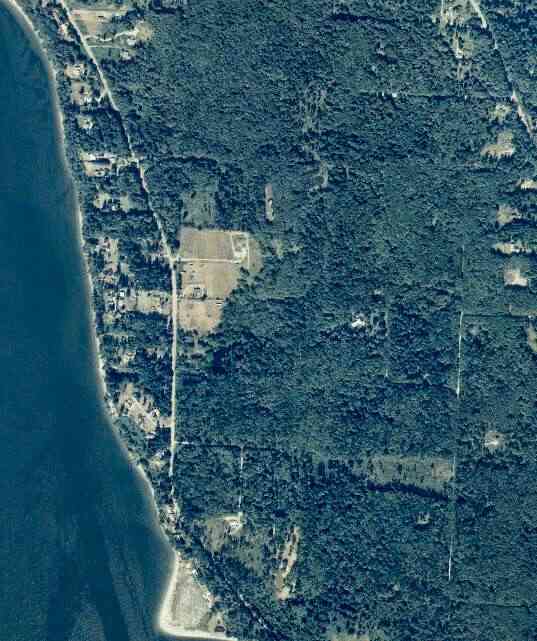
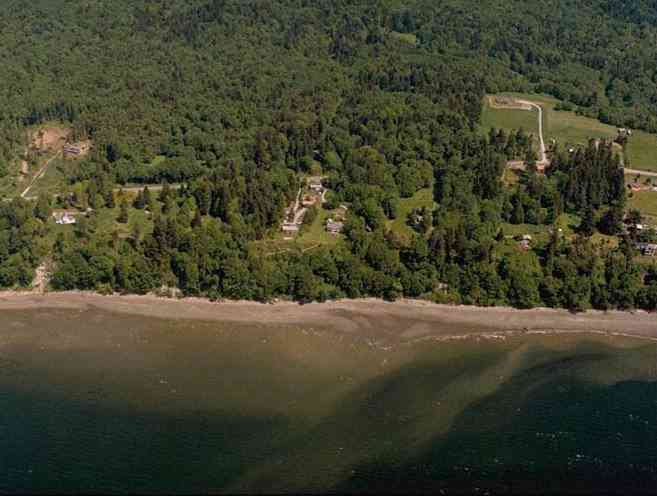
The above September 1997 aerial photo of this section of Camano is from http://www.islandcounty.net/publicworks/digitalphotos/mainmap.htm
The above September 1997 aerial photo of this section of Camano is from
http://www.islandcounty.net/publicworks/digitalphotos/mainmap.htm
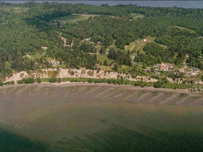
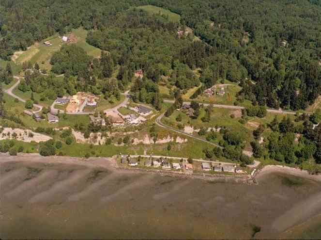
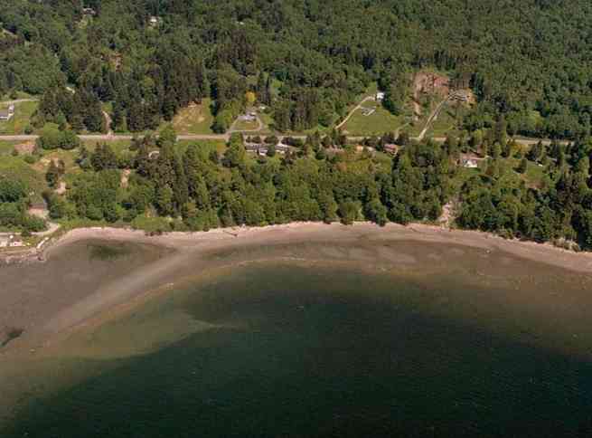
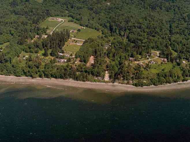
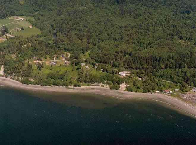
The below 5/11/1993 2:42:00 PM aerial photos are from:
http://apps.ecy.wa.gov/shorephotos
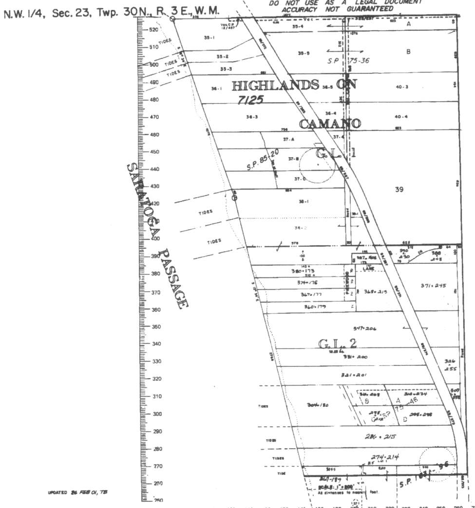
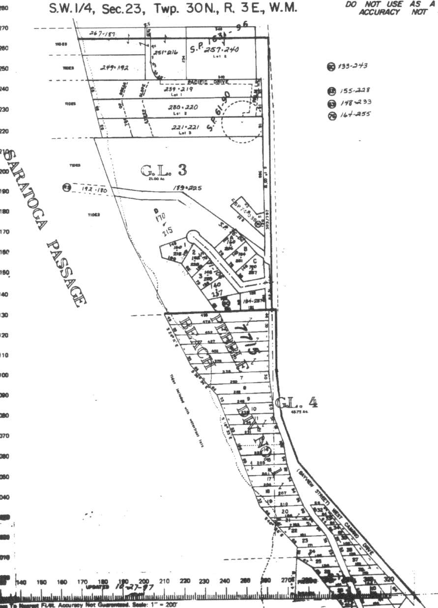
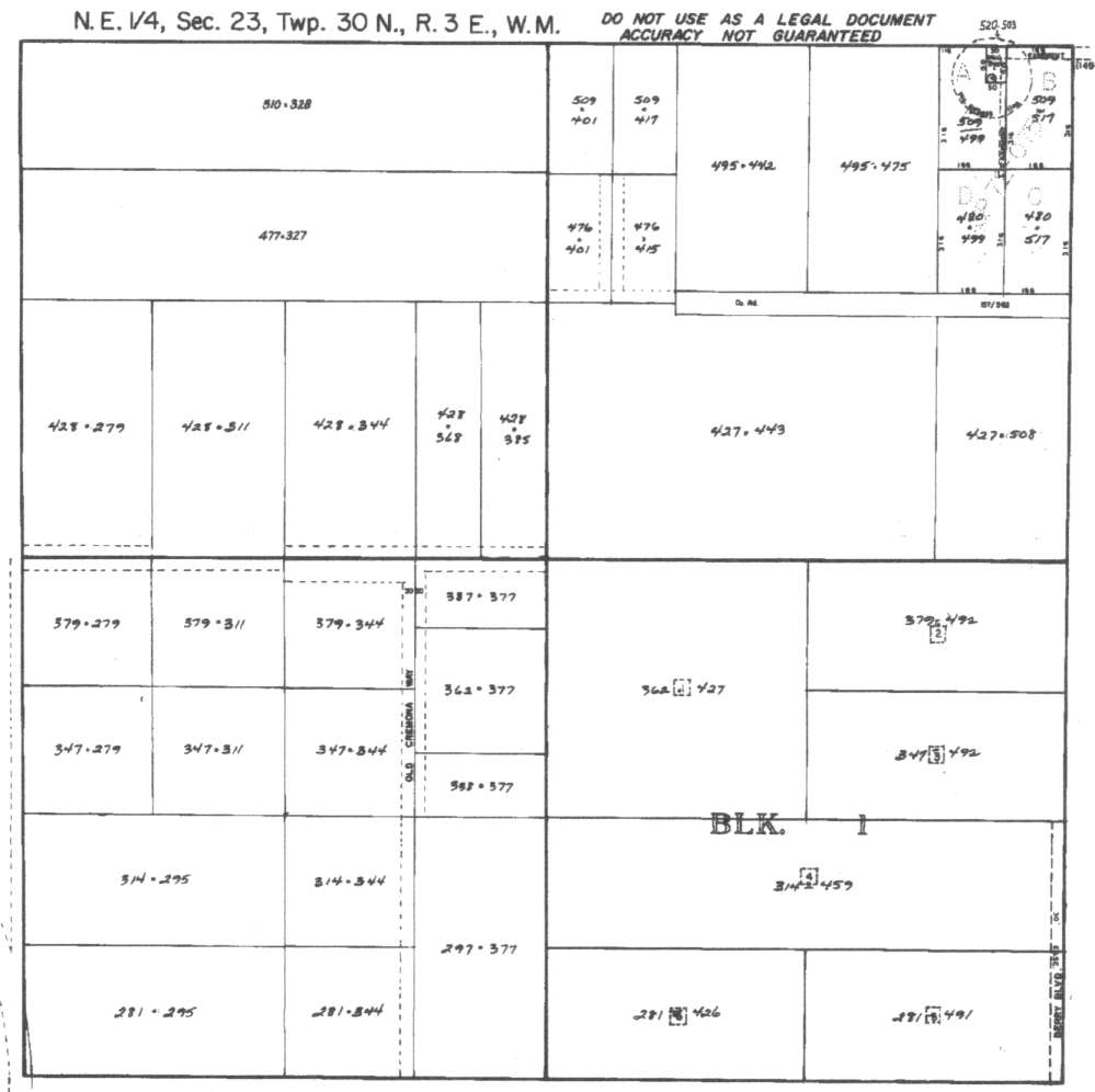
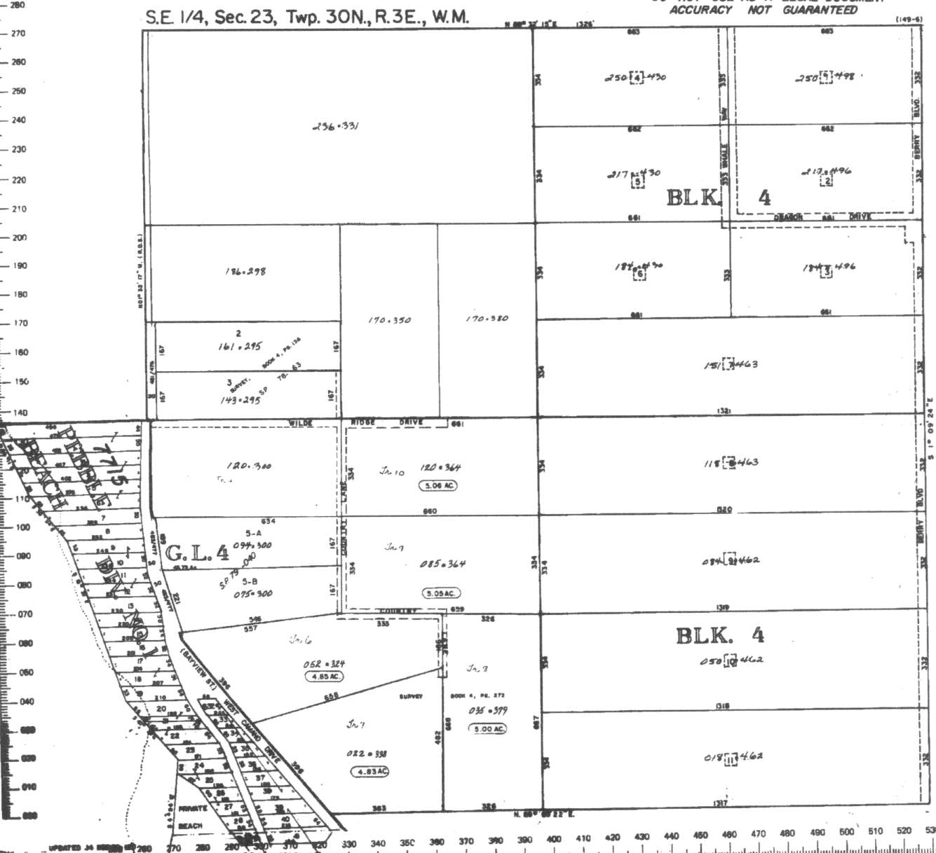
A square system of surveying was ordained by the Continental Congress on May 20, 1785. Within each township (6 miles X 6 miles), are 36 sections. Each section of 640 acres is one mile square (5,280 feet X 5,280 feet). Each quarter section is 160 acres (2,640 feet X 2,640 feet). Most long straight roads and acreage pieces of property have north-south, east-west property lines.
Click on the below Camano section map numbers, to go to a page with Camano Island 2005 assessor data, 1/4 section parcel maps, and aerial photos.
Below are the 34 well reports for this section of Camano, from the December 2004 Washington State Department of Ecology Well log website. Included below is who the well was drilled for, the well depth, and when the well was drilled. At the well log website,
http://apps.ecy.wa.gov/welllog/ more detailed information is available, like the well drillers name, water temperature(sometimes), and soil profile depths.
 <888>
<888>

1. MARGARET POPPĀ - { view PDF
Ā|Ā view TIFF
}
Public Land Survey: NE, SW, S-23, T-30-N, R-03-E, Tax Parcel Number: (blank)
County: ISLAND, Well Address: 1763 PACIFIC DR, CAMANO ISLAND
Well Log ID: 382692, Well Tag ID: AKY875, Notice of Intent Number: W177624
Well Diameter: 6 (inches), Well Depth: 228 (feet)
Well Type: Water, Well Completion Date: 5/21/2004, Well Log Received Date: 6/23/2004
2. BRISKY BROTHERS CONSTĀ - { view PDF
Ā|Ā view TIFF
}
Public Land Survey: SW, SE, S-23, T-30-N, R-03-E, Tax Parcel Number: (blank)
County: ISLAND, Well Address: WILDE RIDGE LANE
Well Log ID: 353655, Well Tag ID: AHG015, Notice of Intent Number: W166082
Well Diameter: 6 (inches), Well Depth: 144.5 (feet)
Well Type: Water, Well Completion Date: 2/3/2003, Well Log Received Date: 2/25/2003
3. NATIONAL LAND AND TIMBERĀ - { view PDF
Ā|Ā view TIFF
}
Public Land Survey: NE, SE, S-23, T-30-N, R-03-E, Tax Parcel Number: (blank)
County: ISLAND, Well Address: DRAGON DR, CAMANO ISLAND, 98282
Well Log ID: 304102, Well Tag ID: ACY375, Notice of Intent Number: W117782
Well Diameter: 6 (inches), Well Depth: 60 (feet)
Well Type: Water, Well Completion Date: 12/1/2000, Well Log Received Date: 12/6/2000
4. GARBER, CATHERINEĀ - { view PDF
Ā|Ā view TIFF
}
Public Land Survey: SE, SE, S-23, T-30-N, R-03-E, Tax Parcel Number: (blank)
County: ISLAND, Well Address: WILDE RIDGE RD
Well Log ID: 256038, Well Tag ID: AFJ863, Notice of Intent Number: W125607
Well Diameter: 6 (inches), Well Depth: 154 (feet)
Well Type: Water, Well Completion Date: 9/7/2000, Well Log Received Date: 9/12/2000
5. MARGRET & BERNARD POPPĀ - { view PDF
Ā|Ā view TIFF
}
Public Land Survey: NW, SE, S-23, T-30-N, R-03-E, Tax Parcel Number: (blank)
County: ISLAND, Well Address: 1763 PACIFIC DR., COMONO ISLAND 98282
Well Log ID: 247294, Well Tag ID: AFJ477, Notice of Intent Number: W077622
Well Diameter: 6 (inches), Well Depth: 271 (feet)
Well Type: Water, Well Completion Date: 8/23/2000, Well Log Received Date: 8/5/2000
6. JOE & ARRON FIRCHAUĀ - { view PDF
Ā|Ā view TIFF
}
Public Land Survey: NW, NE, S-23, T-30-N, R-03-E, Tax Parcel Number: R33023-493-3220
County: ISLAND, Well Address: GARRISON RD, CAMANO ISLAND
Well Log ID: 248122, Well Tag ID: AFK253, Notice of Intent Number: W125705
Well Diameter: 6 (inches), Well Depth: 458 (feet)
Well Type: Water, Well Completion Date: 6/18/2000, Well Log Received Date: 6/3/2000
7. MARY JO RICHARDSONĀ - { view PDF
Ā|Ā view TIFF
}
Public Land Survey: NW, SW, S-23, T-30-N, R-03-E, Tax Parcel Number: (blank)
County: ISLAND, Well Address: 1812 WILD RIDGE DR, CAMANO
Well Log ID: 123468, Well Tag ID: AEN115, Notice of Intent Number: W107089
Well Diameter: 6 (inches), Well Depth: 260 (feet)
Well Type: Water, Well Completion Date: 8/23/1999, Well Log Received Date: 4/23/1999
8. MARK TAYLORĀ - { view PDF
Ā|Ā view TIFF
}
Public Land Survey: SE, SW, S-23, T-30-N, R-03-E, Tax Parcel Number: (blank)
County: ISLAND, Well Address: 4382 S CAMANO DR
Well Log ID: 190617, Well Tag ID: AER458, Notice of Intent Number: W118649
Well Diameter: 6 (inches), Well Depth: 84 (feet)
Well Type: Water, Well Completion Date: 7/23/1999, Well Log Received Date: 8/24/1999
9. STEVE WOLFĀ - { view PDF
Ā|Ā view TIFF
}
Public Land Survey: SW, NE, S-23, T-30-N, R-03-E, Tax Parcel Number: (blank)
County: ISLAND, Well Address: 3980 COUNTRY LN
Well Log ID: 190620, Well Tag ID: AER461, Notice of Intent Number: W114419
Well Diameter: 6 (inches), Well Depth: 298 (feet)
Well Type: Water, Well Completion Date: 6/28/1999, Well Log Received Date: 9/22/1999
10. MARK LAURESĀ - { view PDF
Ā|Ā view TIFF
}
Public Land Survey: SE, SW, S-23, T-30-N, R-03-E, Tax Parcel Number: (blank)
County: ISLAND, Well Address: 4124 S CAMANO DR
Well Log ID: 123553, Well Tag ID: AER215, Notice of Intent Number: W099607
Well Diameter: 6 (inches), Well Depth: 319 (feet)
Well Type: Water, Well Completion Date: 2/11/1999, Well Log Received Date: 4/9/1999
11. ANDREW SCHULMANĀ - { view PDF
Ā|Ā view TIFF
}
Public Land Survey: NW, SE, S-23, T-30-N, R-03-E, Tax Parcel Number: (blank)
County: ISLAND, Well Address: XXX WILDRIDGE RD, CAMANO ISLAND, 98292
Well Log ID: 74416, Well Tag ID: (blank) , Notice of Intent Number: W064596
Well Diameter: 6 (inches), Well Depth: 295 (feet)
Well Type: Water, Well Completion Date: 3/29/1997, Well Log Received Date: 6/12/1997
12. PEBBLE BEACH WATERĀ - { view PDF
Ā|Ā view TIFF
}
Public Land Survey: SW, NW, S-23, T-30-N, R-03-E, Tax Parcel Number: (blank)
County: ISLAND, Well Address: 3952 SW CAMANO DR, CAMANO ISLAND, 98292
Well Log ID: 82857, Well Tag ID: (blank) , Notice of Intent Number: W054365
Well Diameter: 6 (inches), Well Depth: 160 (feet)
Well Type: Water, Well Completion Date: 1/22/1997, Well Log Received Date: 2/24/1997
13. KARIN VENATONĀ - { view PDF
Ā|Ā view TIFF
}
Public Land Survey: NW, SE, S-23, T-30-N, R-03-E, Tax Parcel Number: (blank)
County: ISLAND, Well Address: 1787 E PACIFIC DR, CAMANO ISLAND, 98292
Well Log ID: 80542, Well Tag ID: (blank) , Notice of Intent Number: W073036
Well Diameter: 6 (inches), Well Depth: 297 (feet)
Well Type: Water, Well Completion Date: 5/20/1996, Well Log Received Date: (blank)
14. AVID GLADSTONEĀ - { view PDF
Ā|Ā view TIFF
}
Public Land Survey: NW, SW, S-23, T-30-N, R-03-E, Tax Parcel Number: (blank)
County: ISLAND, Well Address: 3700 W CAMANO DR, CAMANO ISLAND
Well Log ID: 74559, Well Tag ID: (blank) , Notice of Intent Number: A008226
Well Diameter: 30 (inches), Well Depth: 20 (feet)
Well Type: Decommissioned, Well Completion Date: 10/24/1995, Well Log Received Date: 11/29/1995
15. ERICH SCHWEIGERĀ - { view PDF
Ā|Ā view TIFF
}
Public Land Survey: SW, NW, S-23, T-30-N, R-03-E, Tax Parcel Number: (blank)
County: ISLAND, Well Address: 3740 S OLD CREMONA WY, CAMANO ISLAND
Well Log ID: 77722, Well Tag ID: (blank) , Notice of Intent Number: W043599
Well Diameter: 6 (inches), Well Depth: 360 (feet)
Well Type: Water, Well Completion Date: 7/31/1995, Well Log Received Date: 8/8/1995
16. AVID GLADSTONEĀ - { view PDF
Ā|Ā view TIFF
}
Public Land Survey: NW, SW, S-23, T-30-N, R-03-E, Tax Parcel Number: (blank)
County: ISLAND, Well Address: 3700 W CAMANO DR, CAMANO ISLAND
Well Log ID: 74560, Well Tag ID: (blank) , Notice of Intent Number: W053732
Well Diameter: 6 (inches), Well Depth: 235 (feet)
Well Type: Water, Well Completion Date: 6/28/1995, Well Log Received Date: 7/3/1995
17. ROBERT SOKOLIKĀ - { view PDF
Ā|Ā view TIFF
}
Public Land Survey: SW, NE, S-23, T-30-N, R-03-E, Tax Parcel Number: (blank)
County: ISLAND, Well Address: TURK RD
Well Log ID: 86790, Well Tag ID: ABN040, Notice of Intent Number: W064401
Well Diameter: 6 (inches), Well Depth: 180 (feet)
Well Type: Water, Well Completion Date: 4/25/1995, Well Log Received Date: (blank)
18. MARIE THOMPSONĀ - { view PDF
Ā|Ā view TIFF
}
Public Land Survey: NW, NW, S-23, T-30-N, R-03-E, Tax Parcel Number: (blank)
County: ISLAND, Well Address: 36175 W CAMANO DR
Well Log ID: 81572, Well Tag ID: (blank) , Notice of Intent Number: 219068
Well Diameter: 6 (inches), Well Depth: 319 (feet)
Well Type: Water, Well Completion Date: 6/2/1993, Well Log Received Date: 6/18/1993
19. LYLE VOGEZĀ - { view PDF
Ā|Ā view TIFF
}
Public Land Survey: NE, SE, S-23, T-30-N, R-03-E, Tax Parcel Number: (blank)
County: ISLAND, Well Address: 3806 WHALE WY, CAMANO ISLAND
Well Log ID: 81447, Well Tag ID: (blank) , Notice of Intent Number: (blank)
Well Diameter: 6 (inches), Well Depth: 384 (feet)
Well Type: Water, Well Completion Date: 3/30/1992, Well Log Received Date: 4/13/1992
20. OLE BAKKEMĀ - { view PDF
Ā|Ā view TIFF
}
Public Land Survey: SW, NW, S-23, T-30-N, R-03-E, Tax Parcel Number: (blank)
County: ISLAND, Well Address: 3718 S PINEWOOD LN
Well Log ID: 82624, Well Tag ID: (blank) , Notice of Intent Number: 041575
Well Diameter: 6 (inches), Well Depth: 186 (feet)
Well Type: Water, Well Completion Date: 12/31/1991, Well Log Received Date: 1/10/1992
21. RALPH CARPENTERĀ - { view PDF
Ā|Ā view TIFF
}
Public Land Survey: SW, SW, S-23, T-30-N, R-03-E, Tax Parcel Number: (blank)
County: ISLAND, Well Address: 3762 SW CAMANO DR, CAMANO ISLAND
Well Log ID: 83149, Well Tag ID: (blank) , Notice of Intent Number: 040896
Well Diameter: 6 (inches), Well Depth: 196 (feet)
Well Type: Water, Well Completion Date: 10/10/1991, Well Log Received Date: 10/21/1991
22. CHRIS SANDYSĀ - { view PDF
Ā|Ā view TIFF
}
Public Land Survey: NE, NE, S-23, T-30-N, R-03-E, Tax Parcel Number: (blank)
County: ISLAND, Well Address: 1931 E GARRISON RD
Well Log ID: 75834, Well Tag ID: (blank) , Notice of Intent Number: 042036
Well Diameter: 6 (inches), Well Depth: 402 (feet)
Well Type: Water, Well Completion Date: 7/30/1991, Well Log Received Date: 8/8/1991
23. GTEĀ - { view PDF
Ā|Ā view TIFF
}
Public Land Survey: NW, NW, S-23, T-30-N, R-03-E, Tax Parcel Number: (blank)
County: ISLAND, Well Address: CAMANO HEAD, E CAMANO
Well Log ID: 78671, Well Tag ID: (blank) , Notice of Intent Number: 073517
Well Diameter: 6 (inches), Well Depth: 100 (feet)
Well Type: Water, Well Completion Date: 7/30/1991, Well Log Received Date: 8/29/1991
24. GTEĀ - { view PDF
Ā|Ā view TIFF
}
Public Land Survey: (blank), SW, S-23, T-30-N, R-03-E, Tax Parcel Number: (blank)
County: ISLAND, Well Address: CAMANO HEAD W
Well Log ID: 78672, Well Tag ID: (blank) , Notice of Intent Number: 072714
Well Diameter: 6 (inches), Well Depth: 200 (feet)
Well Type: Water, Well Completion Date: 5/28/1991, Well Log Received Date: (blank)
25. CHARLES MANGUMĀ - { view PDF
Ā|Ā view TIFF
}
Public Land Survey: NE, NW, S-23, T-30-N, R-03-E, Tax Parcel Number: (blank)
County: ISLAND, Well Address: 36235 W CAMANO DR, CAMANO ISLAND
Well Log ID: 75733, Well Tag ID: (blank) , Notice of Intent Number: 040855
Well Diameter: 6 (inches), Well Depth: 322 (feet)
Well Type: Water, Well Completion Date: 5/24/1991, Well Log Received Date: 6/21/1991
26. TIM WORLEYĀ - { view PDF
Ā|Ā view TIFF
}
Public Land Survey: SW, NE, S-23, T-30-N, R-03-E, Tax Parcel Number: (blank)
County: ISLAND, Well Address: 3771 SW CAMANO DR, CAMANO ISLAND
Well Log ID: 85196, Well Tag ID: (blank) , Notice of Intent Number: 026748
Well Diameter: 6 (inches), Well Depth: 330 (feet)
Well Type: Water, Well Completion Date: 12/18/1989, Well Log Received Date: 12/20/1989
27. JOHN POSELĀ - { view PDF
Ā|Ā view TIFF
}
Public Land Survey: (blank), SW, S-23, T-30-N, R-03-E, Tax Parcel Number: (blank)
County: ISLAND, Well Address: 3804 S W CAMANO DR, CAMANO ISLAND, 98292
Well Log ID: 80283, Well Tag ID: (blank) , Notice of Intent Number: 023262
Well Diameter: 6 (inches), Well Depth: 255 (feet)
Well Type: Water, Well Completion Date: 7/27/1989, Well Log Received Date: (blank)
28. ROD W CARLSON & SHARRON CARLSONĀ - { view PDF
Ā|Ā view TIFF
}
Public Land Survey: NE, NW, S-23, T-30-N, R-03-E, Tax Parcel Number: (blank)
County: ISLAND, Well Address: (blank)
Well Log ID: 83885, Well Tag ID: (blank) , Notice of Intent Number: (blank)
Well Diameter: 36 (inches), Well Depth: 67 (feet)
Well Type: Water, Well Completion Date: 5/14/1976, Well Log Received Date: (blank)
29. MARVIN TURKĀ - { view PDF
Ā|Ā view TIFF
}
Public Land Survey: SE, NE, S-23, T-30-N, R-03-E, Tax Parcel Number: (blank)
County: ISLAND, Well Address: (blank)
Well Log ID: 81748, Well Tag ID: (blank) , Notice of Intent Number: (blank)
Well Diameter: 36 (inches), Well Depth: 23 (feet)
Well Type: Water, Well Completion Date: 2/18/1974, Well Log Received Date: (blank)
30. DRUMMOND I GREGORYĀ - { view PDF
Ā|Ā view TIFF
}
Public Land Survey: NE, NE, S-23, T-30-N, R-03-E, Tax Parcel Number: (blank)
County: ISLAND, Well Address: (blank)
Well Log ID: 351089, Well Tag ID: AGA508, Notice of Intent Number: (blank)
Well Diameter: 8 (inches), Well Depth: 430 (feet)
Well Type: Water, Well Completion Date: 12/28/1969, Well Log Received Date: (blank)
31. HAROLD ANDERSONĀ - { view PDF
Ā|Ā view TIFF
}
Public Land Survey: NE, SW, S-23, T-30-N, R-03-E, Tax Parcel Number: (blank)
County: ISLAND, Well Address: (blank)
Well Log ID: 351088, Well Tag ID: (blank) , Notice of Intent Number: (blank)
Well Diameter: 6 (inches), Well Depth: 257 (feet)
Well Type: Water, Well Completion Date: 11/13/1968, Well Log Received Date: (blank)
32. KARIN VENATORĀ - { view PDF
Ā|Ā view TIFF
}
Public Land Survey: NE, SE, S-23, T-30-N, R-03-E, Tax Parcel Number: (blank)
County: ISLAND, Well Address: (blank)
Well Log ID: 80543, Well Tag ID: (blank) , Notice of Intent Number: (blank)
Well Diameter: 6 (inches), Well Depth: 257 (feet)
Well Type: Water, Well Completion Date: (blank) , Well Log Received Date: 8/24/1992
33. MERCE DE GARCIAĀ - { view PDF
Ā|Ā view TIFF
}
Public Land Survey: (blank), (blank), S-23, T-30-N, R-03-E, Tax Parcel Number: (blank)
County: ISLAND, Well Address: (blank)
Well Log ID: 81865, Well Tag ID: (blank) , Notice of Intent Number: (blank)
Well Diameter: 6 (inches), Well Depth: 269 (feet)
Well Type: Water, Well Completion Date: (blank) , Well Log Received Date: (blank)
34. OLE BAKKENĀ - { view PDF
Ā|Ā view TIFF
}
Public Land Survey: SE, NW, S-23, T-30-N, R-03-E, Tax Parcel Number: (blank)
County: ISLAND, Well Address: (blank)
Well Log ID: 285482, Well Tag ID: (blank) , Notice of Intent Number: (blank)
Well Diameter: 36 (inches), Well Depth: 38 (feet)
Well Type: Water, Well Completion Date: (blank) , Well Log Received Date: (blank)