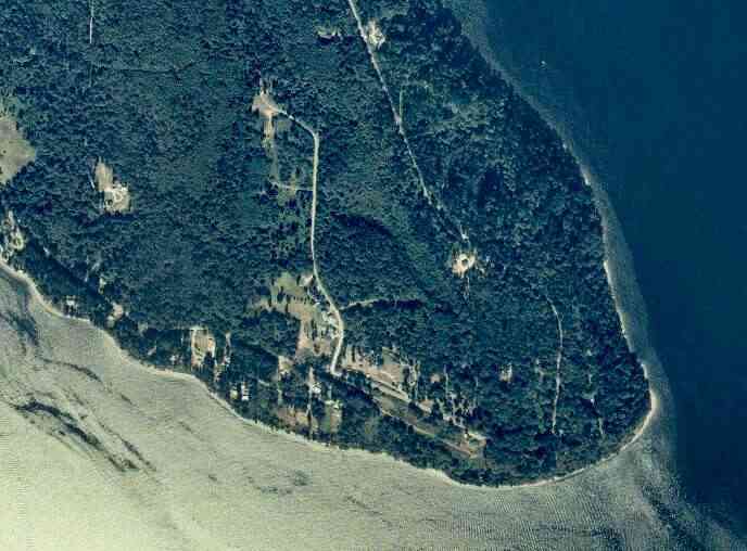
The above September 1997 aerial photo of this section of Camano is from http://www.islandcounty.net/publicworks/digitalphotos/mainmap.htm
The above September 1997 aerial photo of this section of Camano is from
http://www.islandcounty.net/publicworks/digitalphotos/mainmap.htm
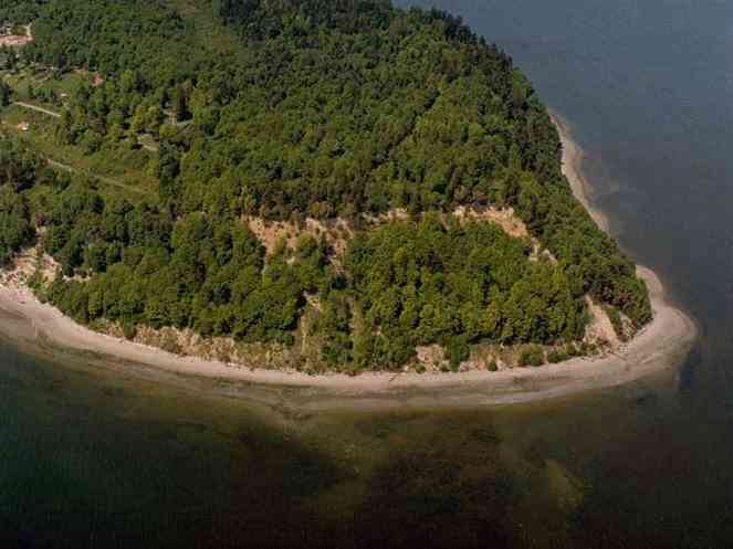
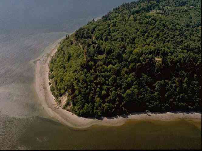
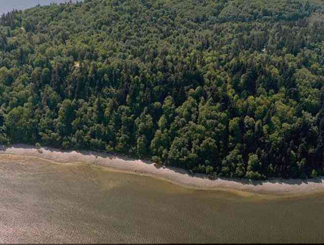
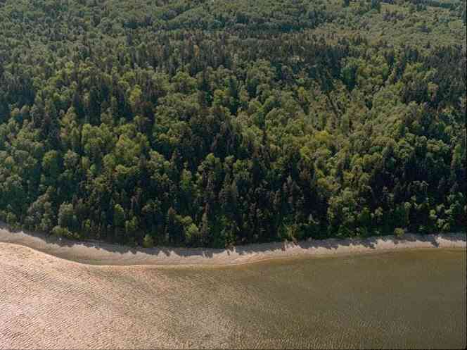
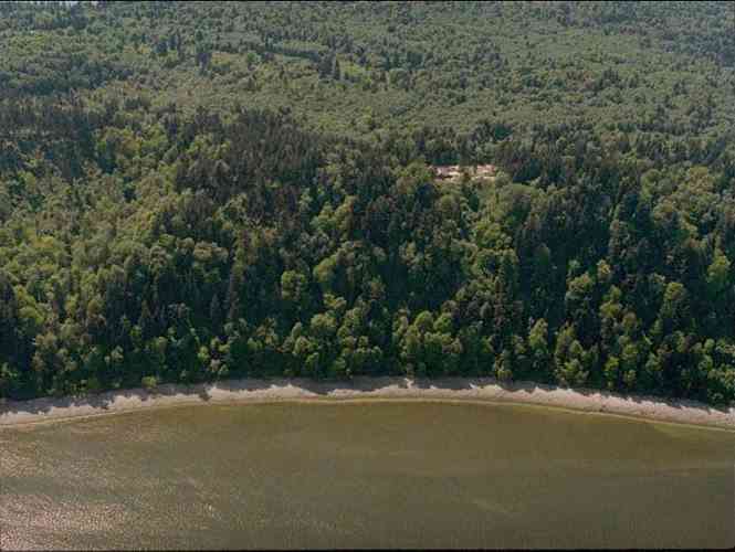
The below 5/11/1993 2:42:00 PM aerial photos are from:
http://apps.ecy.wa.gov/shorephotos
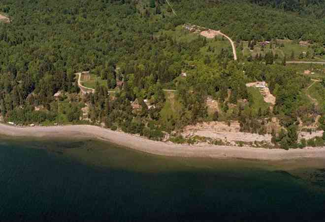
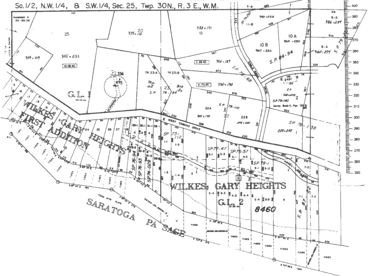
Wilkes Gary Heights, west side of Camano

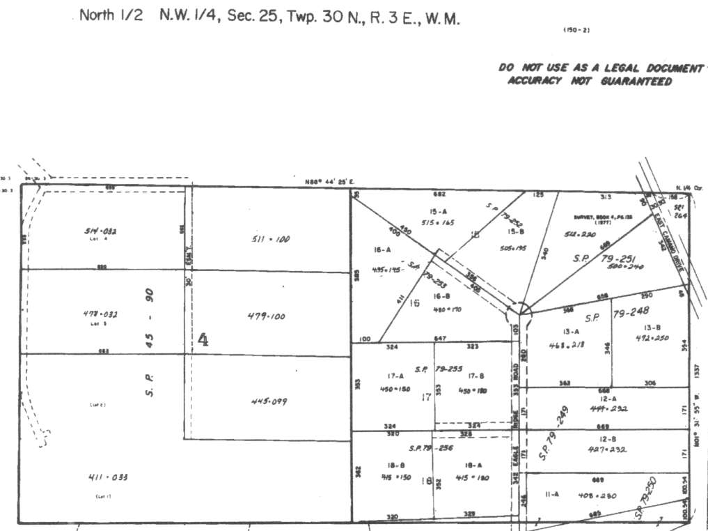
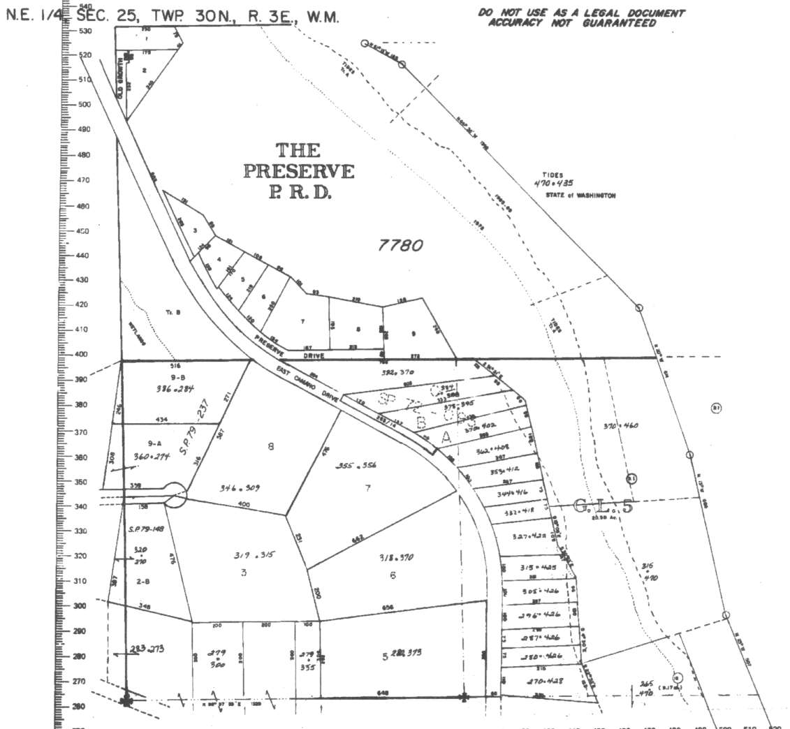
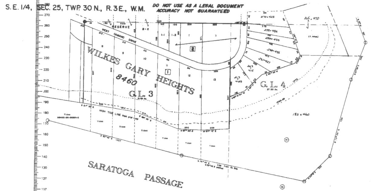
A square system of surveying was ordained by the Continental Congress on May 20, 1785. Within each township (6 miles X 6 miles), are 36 sections. Each section of 640 acres is one mile square (5,280 feet X 5,280 feet). Each quarter section is 160 acres (2,640 feet X 2,640 feet). Most long straight roads and acreage pieces of property have north-south, east-west property lines.
Click on the below Camano section map numbers, to go to a page with Camano Island 2005 assessor data, 1/4 section parcel maps, and aerial photos.
Below are the 27 well reports for this section of Camano, from the December 2004 Washington State Department of Ecology Well log website. Included below is who the well was drilled for, the well depth, and when the well was drilled. At the well log website,
http://apps.ecy.wa.gov/welllog/ more detailed information is available, like the well drillers name, water temperature(sometimes), and soil profile depths.
 <888>
<888>

1. BOB AND DENA AITKENĀ - { view PDF
Ā|Ā view TIFF
}
Public Land Survey: NW, SW, S-25, T-30-N, R-03-E, Tax Parcel Number: (blank)
County: ISLAND, Well Address: W CAMANO DR, CAMANO ISLAND
Well Log ID: 390694, Well Tag ID: AKY967, Notice of Intent Number: W182244
Well Diameter: 6 (inches), Well Depth: 60.5 (feet)
Well Type: Water, Well Completion Date: 9/27/2004, Well Log Received Date: 10/13/2004
2. ESTER GOLDENĀ - { view PDF
Ā|Ā view TIFF
}
Public Land Survey: NW, SE, S-25, T-30-N, R-03-E, Tax Parcel Number: (blank)
County: ISLAND, Well Address: 49XX W CAMANO RD, CAMANO ISLAND
Well Log ID: 368278, Well Tag ID: AKY829, Notice of Intent Number: W153996
Well Diameter: 6 (inches), Well Depth: 313 (feet)
Well Type: Water, Well Completion Date: 8/15/2003, Well Log Received Date: 9/5/2003
3. PAUL NUGENTĀ - { view PDF
Ā|Ā view TIFF
}
Public Land Survey: NW, SW, S-25, T-30-N, R-03-E, Tax Parcel Number: (blank)
County: ISLAND, Well Address: 2157 GULL WAY
Well Log ID: 365401, Well Tag ID: AKY812, Notice of Intent Number: W153950
Well Diameter: 6 (inches), Well Depth: 298.5 (feet)
Well Type: Water, Well Completion Date: 6/4/2003, Well Log Received Date: 7/10/2003
4. SUN MOUNTAIN CONSTRUCTIONĀ - { view PDF
Ā|Ā view TIFF
}
Public Land Survey: NE, NE, S-25, T-30-N, R-03-E, Tax Parcel Number: (blank)
County: ISLAND, Well Address: XXX E CAMANO ROAD, CAMANO ISLAND
Well Log ID: 367894, Well Tag ID: AGF430, Notice of Intent Number: W156090
Well Diameter: 6 (inches), Well Depth: 170 (feet)
Well Type: Water, Well Completion Date: 5/30/2003, Well Log Received Date: 8/29/2003
5. SUN MOUNTAIN CONSTRUCTIONĀ - { view PDF
Ā|Ā view TIFF
}
Public Land Survey: NE, NE, S-25, T-30-N, R-03-E, Tax Parcel Number: (blank)
County: ISLAND, Well Address: XXX EAST CAMANO ROAD, CAMANO ISLAND
Well Log ID: 367889, Well Tag ID: AGF431, Notice of Intent Number: W156091
Well Diameter: 5 (inches), Well Depth: 165 (feet)
Well Type: Water, Well Completion Date: 5/29/2003, Well Log Received Date: 8/29/2003
6. EUROCRAFT CARPENTRYĀ - { view PDF
Ā|Ā view TIFF
}
Public Land Survey: NW, NE, S-25, T-30-N, R-03-E, Tax Parcel Number: (blank)
County: ISLAND, Well Address: 3800 RD, CAMANO ISLAND
Well Log ID: 331852, Well Tag ID: AEJ901, Notice of Intent Number: W151682
Well Diameter: 6 (inches), Well Depth: 258 (feet)
Well Type: Water, Well Completion Date: 3/22/2002, Well Log Received Date: 4/8/2002
7. ANDY WORLSEYĀ - { view PDF
Ā|Ā view TIFF
}
Public Land Survey: SW, SW, S-25, T-30-N, R-03-E, Tax Parcel Number: (blank)
County: ISLAND, Well Address: SOUTH END CAMANO
Well Log ID: 305339, Well Tag ID: AFK010, Notice of Intent Number: W120069
Well Diameter: 6 (inches), Well Depth: 526 (feet)
Well Type: Water, Well Completion Date: 6/22/2001, Well Log Received Date: 7/24/2001
8. ROLF LAITENBERGERĀ - { view PDF
Ā|Ā view TIFF
}
Public Land Survey: NW, NW, S-25, T-30-N, R-03-E, Tax Parcel Number: (blank)
County: ISLAND, Well Address: XXXX 3800 RD, CAMANO ISLAND
Well Log ID: 305292, Well Tag ID: AFG969, Notice of Intent Number: W124140
Well Diameter: 6 (inches), Well Depth: 400 (feet)
Well Type: Water, Well Completion Date: 4/30/2001, Well Log Received Date: 5/8/2001
9. COACH CORRAL C/O SCOTT ACHESONĀ - { view PDF
Ā|Ā view TIFF
}
Public Land Survey: NW, NW, S-25, T-30-N, R-03-E, Tax Parcel Number: (blank)
County: ISLAND, Well Address: (blank)
Well Log ID: 247751, Well Tag ID: AFG226, Notice of Intent Number: W122590
Well Diameter: 6 (inches), Well Depth: 348 (feet)
Well Type: Water, Well Completion Date: 7/26/2000, Well Log Received Date: 8/3/2000
10. ZENTZ ALLENĀ - { view PDF
Ā|Ā view TIFF
}
Public Land Survey: SW, NE, S-25, T-30-N, R-03-E, Tax Parcel Number: (blank)
County: ISLAND, Well Address: 4108 SE CAMANO DRIVE
Well Log ID: 247752, Well Tag ID: AFJ871, Notice of Intent Number: W125563
Well Diameter: 6 (inches), Well Depth: 135 (feet)
Well Type: Water, Well Completion Date: 7/6/2000, Well Log Received Date: 8/1/2000
11. COLEMANĀ - { view PDF
Ā|Ā view TIFF
}
Public Land Survey: NE, NE, S-25, T-30-N, R-03-E, Tax Parcel Number: R33035-250-4330
County: ISLAND, Well Address: SE CAMANO DR
Well Log ID: 190068, Well Tag ID: ABD012, Notice of Intent Number: W075073
Well Diameter: 6 (inches), Well Depth: 384 (feet)
Well Type: Water, Well Completion Date: 7/12/1999, Well Log Received Date: (blank)
12. PAUL EASTERĀ - { view PDF
Ā|Ā view TIFF
}
Public Land Survey: NW, NW, S-25, T-30-N, R-03-E, Tax Parcel Number: (blank)
County: ISLAND, Well Address: BERRY BLVD, CAMANO ISLAND
Well Log ID: 86415, Well Tag ID: ABC736, Notice of Intent Number: W075095
Well Diameter: 6 (inches), Well Depth: 380 (feet)
Well Type: Water, Well Completion Date: 8/20/1998, Well Log Received Date: 9/3/1998
13. MARK HEINĀ - { view PDF
Ā|Ā view TIFF
}
Public Land Survey: SW, NE, S-25, T-30-N, R-03-E, Tax Parcel Number: (blank)
County: ISLAND, Well Address: BRAINERS RD
Well Log ID: 81625, Well Tag ID: (blank) , Notice of Intent Number: W100021
Well Diameter: 6 (inches), Well Depth: 442 (feet)
Well Type: Water, Well Completion Date: 12/2/1997, Well Log Received Date: 12/8/1997
14. EILEEN & ROBERT LAMBERTSONĀ - { view PDF
Ā|Ā view TIFF
}
Public Land Survey: SW, NE, S-25, T-30-N, R-03-E, Tax Parcel Number: (blank)
County: ISLAND, Well Address: SE CAMANO
Well Log ID: 77629, Well Tag ID: (blank) , Notice of Intent Number: W054341
Well Diameter: 6 (inches), Well Depth: 380 (feet)
Well Type: Water, Well Completion Date: 11/21/1995, Well Log Received Date: 12/4/1995
15. ROGERT & EILEEN A. LAMBERTSONĀ - { view PDF
Ā|Ā view TIFF
}
Public Land Survey: NW, SW, S-25, T-30-N, R-03-E, Tax Parcel Number: (blank)
County: ISLAND, Well Address: SE. CAMANO 4184
Well Log ID: 248121, Well Tag ID: (blank) , Notice of Intent Number: W054341
Well Diameter: 6 (inches), Well Depth: 380 (feet)
Well Type: Water, Well Completion Date: 11/21/1995, Well Log Received Date: (blank)
16. BURT GARRISONĀ - { view PDF
Ā|Ā view TIFF
}
Public Land Survey: SE, NW, S-25, T-30-N, R-03-E, Tax Parcel Number: (blank)
County: ISLAND, Well Address: EAGLE RIDGE DR
Well Log ID: 75455, Well Tag ID: (blank) , Notice of Intent Number: W054011
Well Diameter: 6 (inches), Well Depth: 390 (feet)
Well Type: Water, Well Completion Date: 1/2/1995, Well Log Received Date: 1/12/1995
17. BURT BARRISONĀ - { view PDF
Ā|Ā view TIFF
}
Public Land Survey: NW, NW, S-25, T-30-N, R-03-E, Tax Parcel Number: (blank)
County: ISLAND, Well Address: EAGLE RIDGE
Well Log ID: 75452, Well Tag ID: (blank) , Notice of Intent Number: (blank)
Well Diameter: 6 (inches), Well Depth: 375 (feet)
Well Type: Water, Well Completion Date: 5/19/1994, Well Log Received Date: 6/3/1994
18. RICHARD STEELEĀ - { view PDF
Ā|Ā view TIFF
}
Public Land Survey: SE, SE, S-25, T-30-N, R-03-E, Tax Parcel Number: (blank)
County: ISLAND, Well Address: SW CAMANO DR, CAMANO ISLAND, 98292
Well Log ID: 83500, Well Tag ID: (blank) , Notice of Intent Number: W043153
Well Diameter: 6 (inches), Well Depth: 351 (feet)
Well Type: Water, Well Completion Date: 3/4/1994, Well Log Received Date: 5/16/1994
19. CLIFFORD SPINGLERĀ - { view PDF
Ā|Ā view TIFF
}
Public Land Survey: NW, SE, S-25, T-30-N, R-03-E, Tax Parcel Number: (blank)
County: ISLAND, Well Address: SW CAMANO DR, CAMANO ISLAND
Well Log ID: 75993, Well Tag ID: (blank) , Notice of Intent Number: W009714
Well Diameter: 6 (inches), Well Depth: 191 (feet)
Well Type: Water, Well Completion Date: 10/20/1993, Well Log Received Date: 11/2/1993
20. BURT BARRISONĀ - { view PDF
Ā|Ā view TIFF
}
Public Land Survey: NW, NW, S-25, T-30-N, R-03-E, Tax Parcel Number: (blank)
County: ISLAND, Well Address: (blank)
Well Log ID: 75453, Well Tag ID: (blank) , Notice of Intent Number: 219377
Well Diameter: 6 (inches), Well Depth: 438 (feet)
Well Type: Water, Well Completion Date: 5/27/1993, Well Log Received Date: 6/18/1993
21. BURT GARRISONĀ - { view PDF
Ā|Ā view TIFF
}
Public Land Survey: NE, NW, S-25, T-30-N, R-03-E, Tax Parcel Number: (blank)
County: ISLAND, Well Address: SOUTH TIP CAMANO
Well Log ID: 330242, Well Tag ID: (blank) , Notice of Intent Number: (blank)
Well Diameter: 6 (inches), Well Depth: 438 (feet)
Well Type: Water, Well Completion Date: 5/27/1993, Well Log Received Date: (blank)
22. HOWARD WESTĀ - { view PDF
Ā|Ā view TIFF
}
Public Land Survey: NE, NE, S-25, T-30-N, R-03-E, Tax Parcel Number: (blank)
County: ISLAND, Well Address: BERRY BLVD, CAMANO ISLAND
Well Log ID: 79001, Well Tag ID: (blank) , Notice of Intent Number: 073215
Well Diameter: (blank) , Well Depth: (blank)
Well Type: Water, Well Completion Date: 2/26/1993, Well Log Received Date: 3/24/1993
23. HOWARD WESTĀ - { view PDF
Ā|Ā view TIFF
}
Public Land Survey: NE, NE, S-25, T-30-N, R-03-E, Tax Parcel Number: (blank)
County: ISLAND, Well Address: BERRY BLVD, CAMANO ISLAND
Well Log ID: 79002, Well Tag ID: (blank) , Notice of Intent Number: 073213
Well Diameter: 6 (inches), Well Depth: (blank)
Well Type: Water, Well Completion Date: 2/23/1993, Well Log Received Date: 3/24/1993
24. ROLF LAITEN BERGERĀ - { view PDF
Ā|Ā view TIFF
}
Public Land Survey: NW, NW, S-25, T-30-N, R-03-E, Tax Parcel Number: (blank)
County: ISLAND, Well Address: BERRY LN, CAMANO ISLAND, 98292
Well Log ID: 83952, Well Tag ID: (blank) , Notice of Intent Number: (blank)
Well Diameter: 6 (inches), Well Depth: 373 (feet)
Well Type: Water, Well Completion Date: 10/29/1991, Well Log Received Date: 11/7/1991
25. NARTY & MEHLĀ - { view PDF
Ā|Ā view TIFF
}
Public Land Survey: SE, NE, S-25, T-30-N, R-03-E, Tax Parcel Number: (blank)
County: ISLAND, Well Address: 40955 E CAMANO
Well Log ID: 82423, Well Tag ID: (blank) , Notice of Intent Number: 072418
Well Diameter: (blank) , Well Depth: 408 (feet)
Well Type: Water, Well Completion Date: 2/28/1990, Well Log Received Date: 3/27/1990
26. MARTY MEHLĀ - { view PDF
Ā|Ā view TIFF
}
Public Land Survey: SE, NE, S-25, T-30-N, R-03-E, Tax Parcel Number: (blank)
County: ISLAND, Well Address: 40955 E CAMANO ISLAND
Well Log ID: 81716, Well Tag ID: (blank) , Notice of Intent Number: A072418
Well Diameter: 6 (inches), Well Depth: 315 (feet)
Well Type: Decommissioned, Well Completion Date: 2/14/1990, Well Log Received Date: 3/27/1990
27. POINT ALLAN WAKED ASSOCĀ - { view PDF
Ā|Ā view TIFF
}
Public Land Survey: SW, NW, S-25, T-30-N, R-03-E, Tax Parcel Number: (blank)
County: ISLAND, Well Address: GULL WY AND S CAMANO
Well Log ID: 83011, Well Tag ID: AAF241, Notice of Intent Number: (blank)
Well Diameter: 6 (inches), Well Depth: 231 (feet)
Well Type: Water, Well Completion Date: 9/6/1974, Well Log Received Date: (blank)