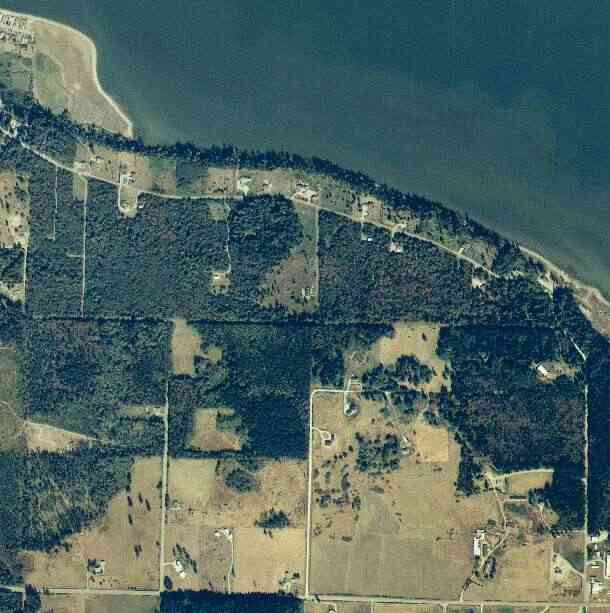
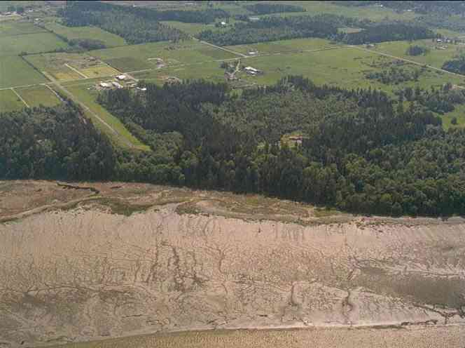
The above September 1997 aerial photo of this section of Camano is from http://www.islandcounty.net/publicworks/digitalphotos/mainmap.htm
The above September 1997 aerial photo of this section of Camano is from
http://www.islandcounty.net/publicworks/digitalphotos/mainmap.htm
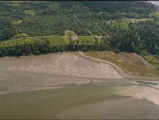
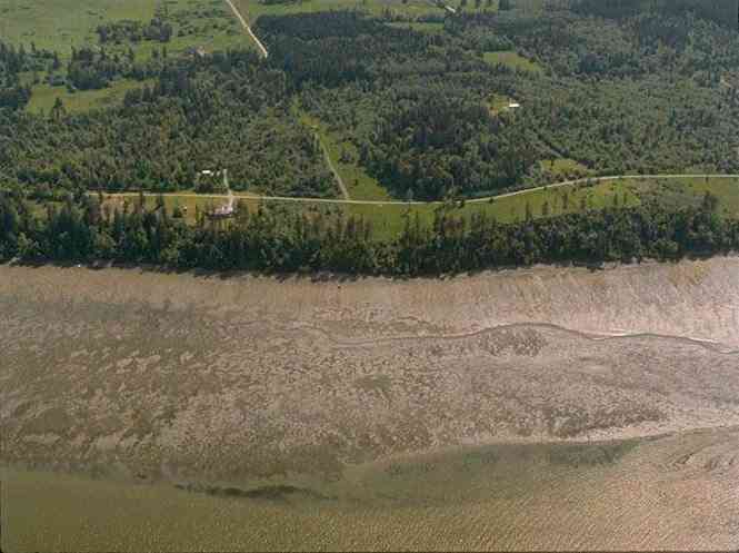
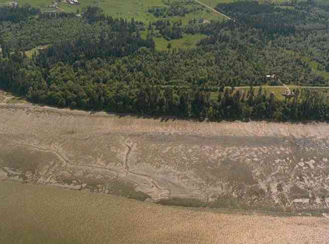
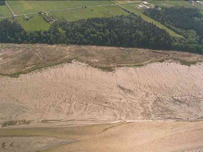
The below 5/11/1993 2:42:00 PM aerial photos are from:
http://apps.ecy.wa.gov/shorephotos
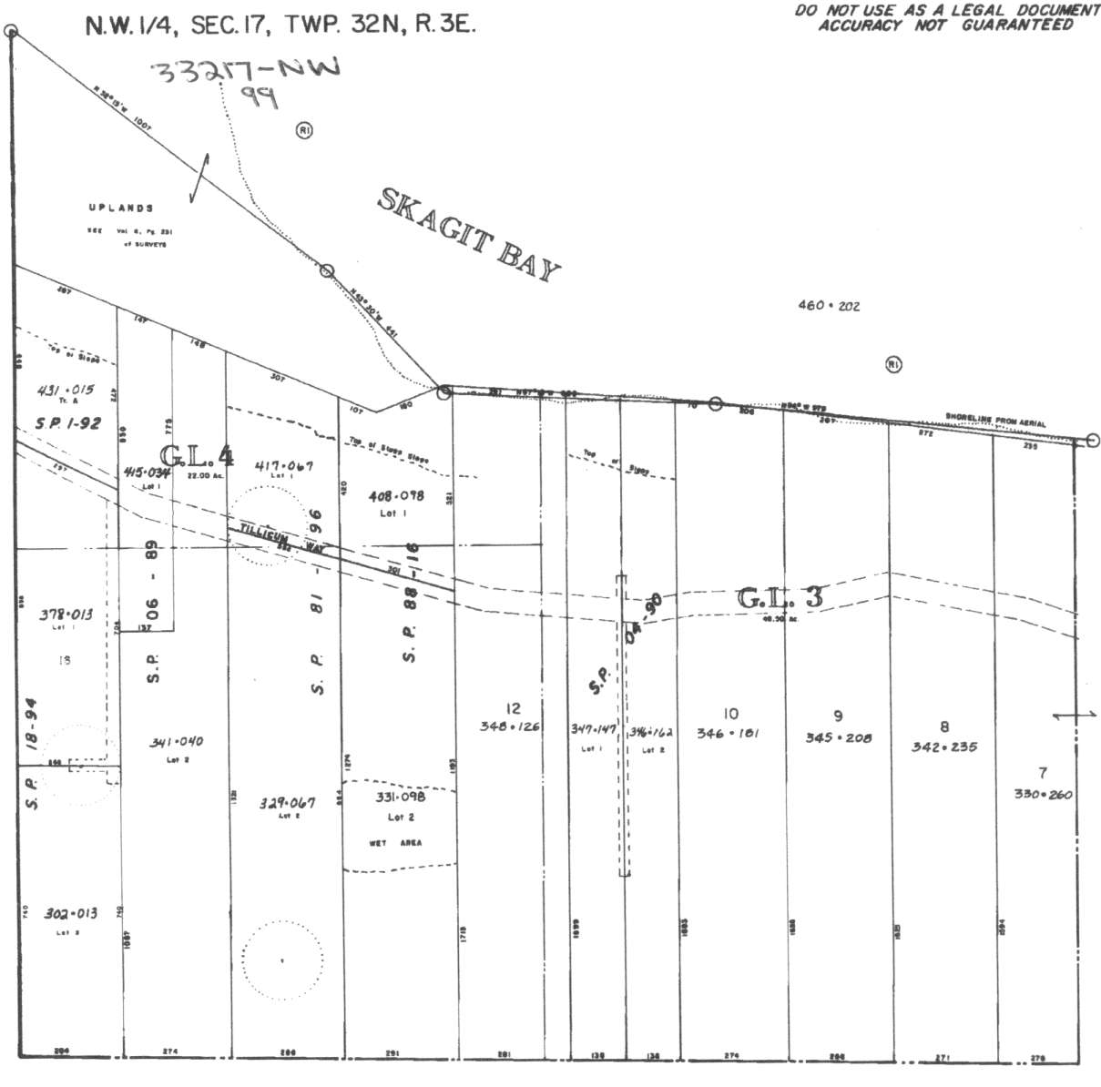
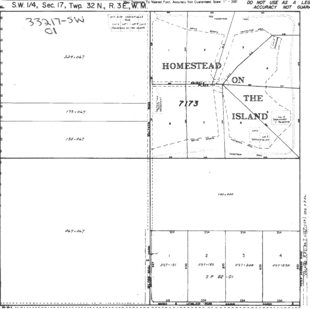
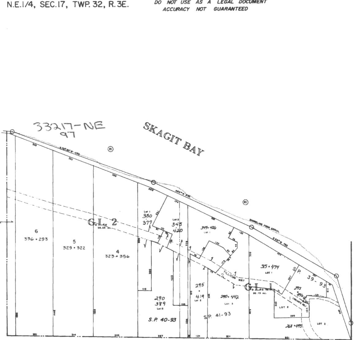
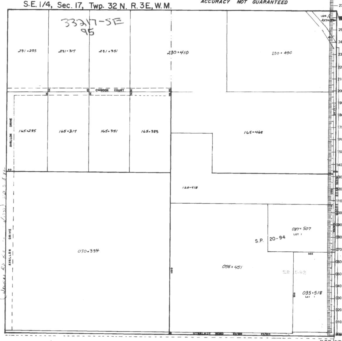
A square system of surveying was ordained by the Continental Congress on May 20, 1785. Within each township (6 miles X 6 miles), are 36 sections. Each section of 640 acres is one mile square (5,280 feet X 5,280 feet). Each quarter section is 160 acres (2,640 feet X 2,640 feet). Most long straight roads and acreage pieces of property have north-south, east-west property lines.
Click on the below Camano section map numbers, to go to a page with Camano Island 2005 assessor data, 1/4 section parcel maps, and aerial photos.
Below are the 38 well reports for this section of Camano, from the December 2004 Washington State Department of Ecology Well log website. Included below is who the well was drilled for, the well depth, and when the well was drilled. At the well log website,
http://apps.ecy.wa.gov/welllog/ more detailed information is available, like the well drillers name, water temperature(sometimes), and soil profile depths.
 <888>
<888>

1. BILL GARDNERĀ - { view PDF
Ā|Ā view TIFF
}
Public Land Survey: NE, SW, S-17, T-32-N, R-03-E, Tax Parcel Number: (blank)
County: ISLAND, Well Address: 545 BRINDAL PL, CAMANO ISLAND 98282
Well Log ID: 379470, Well Tag ID: AGF465, Notice of Intent Number: W156127
Well Diameter: 6 (inches), Well Depth: 220 (feet)
Well Type: Water, Well Completion Date: 3/30/2004, Well Log Received Date: 5/12/2004
2. MARK STITESĀ - { view PDF
Ā|Ā view TIFF
}
Public Land Survey: NE, SW, S-17, T-32-N, R-03-E, Tax Parcel Number: (blank)
County: ISLAND, Well Address: XXX BRINDEL PL, CAMANO ISLAND
Well Log ID: 366559, Well Tag ID: AGF432, Notice of Intent Number: W156092
Well Diameter: 6 (inches), Well Depth: 210 (feet)
Well Type: Water, Well Completion Date: 6/8/2003, Well Log Received Date: 8/6/2003
3. MIRCO PIAZZIĀ - { view PDF
Ā|Ā view TIFF
}
Public Land Survey: NE, SW, S-17, T-32-N, R-03-E, Tax Parcel Number: 57173-00-00004-0
County: ISLAND, Well Address: 549 BRINDLE PL, CAMANO ISLAND
Well Log ID: 354998, Well Tag ID: AHH626, Notice of Intent Number: W167912
Well Diameter: 6 (inches), Well Depth: 199 (feet)
Well Type: Water, Well Completion Date: 1/30/2003, Well Log Received Date: 3/5/2003
4. MARK GOSNOLDĀ - { view PDF
Ā|Ā view TIFF
}
Public Land Survey: SW, SW, S-17, T-32-N, R-03-E, Tax Parcel Number: 7173-00-00008-0
County: ISLAND, Well Address: 518 BRINDLE PL, CAMANO ISLAND
Well Log ID: 347309, Well Tag ID: AHB797, Notice of Intent Number: W161887
Well Diameter: 6 (inches), Well Depth: 196.5 (feet)
Well Type: Water, Well Completion Date: 10/18/2002, Well Log Received Date: 11/27/2002
5. WILLIAM CHELLISĀ - { view PDF
Ā|Ā view TIFF
}
Public Land Survey: NE, SW, S-17, T-32-N, R-03-E, Tax Parcel Number: (blank)
County: ISLAND, Well Address: 535 BRINDLE PL, CAMANO ISLAND, 98282
Well Log ID: 314576, Well Tag ID: AFJ790, Notice of Intent Number: W118525
Well Diameter: 6 (inches), Well Depth: 198 (feet)
Well Type: Water, Well Completion Date: 10/17/2001, Well Log Received Date: 11/21/2001
6. RICH IMUSĀ - { view PDF
Ā|Ā view TIFF
}
Public Land Survey: SE, NE, S-17, T-32-N, R-03-E, Tax Parcel Number: (blank)
County: ISLAND, Well Address: 691 W TILLICUM WY, CAMANO ISLAND
Well Log ID: 190024, Well Tag ID: AAX531, Notice of Intent Number: W116477
Well Diameter: 6 (inches), Well Depth: 160 (feet)
Well Type: Water, Well Completion Date: 8/26/1999, Well Log Received Date: 9/16/1999
7. JULIE WEISSĀ - { view PDF
Ā|Ā view TIFF
}
Public Land Survey: SW, NE, S-17, T-32-N, R-03-E, Tax Parcel Number: (blank)
County: ISLAND, Well Address: CHINOOK, CAMANO ISLAND
Well Log ID: 190517, Well Tag ID: AEN147, Notice of Intent Number: W116470
Well Diameter: 6 (inches), Well Depth: 210 (feet)
Well Type: Water, Well Completion Date: 7/30/1999, Well Log Received Date: 8/16/1999
8. JOHN ELLISONĀ - { view PDF
Ā|Ā view TIFF
}
Public Land Survey: SW, SW, S-17, T-32-N, R-03-E, Tax Parcel Number: (blank)
County: ISLAND, Well Address: ARROWHEAD, CAMANO IS
Well Log ID: 123467, Well Tag ID: AEN119, Notice of Intent Number: W107086
Well Diameter: 6 (inches), Well Depth: 149 (feet)
Well Type: Water, Well Completion Date: 4/23/1999, Well Log Received Date: 5/7/1999
9. CAMILE SUGRUEĀ - { view PDF
Ā|Ā view TIFF
}
Public Land Survey: NW, NW, S-17, T-32-N, R-03-E, Tax Parcel Number: (blank)
County: ISLAND, Well Address: 422 E TILLICUM WY, CAMANO ISLAND, 98292
Well Log ID: 73668, Well Tag ID: ACQ056, Notice of Intent Number: W077167
Well Diameter: 6 (inches), Well Depth: 166 (feet)
Well Type: Water, Well Completion Date: 10/29/1998, Well Log Received Date: 11/16/1998
10. BONNIE BRINDLEĀ - { view PDF
Ā|Ā view TIFF
}
Public Land Survey: NW, SW, S-17, T-32-N, R-03-E, Tax Parcel Number: (blank)
County: ISLAND, Well Address: ROLFSON RD
Well Log ID: 61914, Well Tag ID: (blank) , Notice of Intent Number: W090886
Well Diameter: 6 (inches), Well Depth: 198 (feet)
Well Type: Water, Well Completion Date: 7/7/1997, Well Log Received Date: 7/17/1997
11. RICH IMUSĀ - { view PDF
Ā|Ā view TIFF
}
Public Land Survey: SE, NE, S-17, T-32-N, R-03-E, Tax Parcel Number: (blank)
County: ISLAND, Well Address: (blank)
Well Log ID: 69650, Well Tag ID: (blank) , Notice of Intent Number: W064471
Well Diameter: 6 (inches), Well Depth: 138 (feet)
Well Type: Water, Well Completion Date: 10/31/1996, Well Log Received Date: 11/13/1996
12. RICH IMUSĀ - { view PDF
Ā|Ā view TIFF
}
Public Land Survey: SE, NE, S-17, T-32-N, R-03-E, Tax Parcel Number: (blank)
County: ISLAND, Well Address: CAMANO ISLAND
Well Log ID: 69651, Well Tag ID: (blank) , Notice of Intent Number: W063170
Well Diameter: 6 (inches), Well Depth: 178 (feet)
Well Type: Water, Well Completion Date: 9/27/1996, Well Log Received Date: 10/16/1995
13. JAMES SMITHĀ - { view PDF
Ā|Ā view TIFF
}
Public Land Survey: SE, SE, S-17, T-32-N, R-03-E, Tax Parcel Number: (blank)
County: ISLAND, Well Address: 1263 W MOORE RD, CAMANO ISLAND
Well Log ID: 65624, Well Tag ID: (blank) , Notice of Intent Number: W064524
Well Diameter: 6 (inches), Well Depth: 199 (feet)
Well Type: Water, Well Completion Date: 6/5/1996, Well Log Received Date: 6/26/1996
14. JOHN LEWISĀ - { view PDF
Ā|Ā view TIFF
}
Public Land Survey: NW, SE, S-17, T-32-N, R-03-E, Tax Parcel Number: (blank)
County: ISLAND, Well Address: CHINOOK CT AND AVALON RD, CAMANO ISLAND
Well Log ID: 66380, Well Tag ID: (blank) , Notice of Intent Number: W043594
Well Diameter: 6 (inches), Well Depth: 200 (feet)
Well Type: Water, Well Completion Date: 8/16/1995, Well Log Received Date: 9/20/1995
15. STAN MEYERĀ - { view PDF
Ā|Ā view TIFF
}
Public Land Survey: SE, SW, S-17, T-32-N, R-03-E, Tax Parcel Number: (blank)
County: ISLAND, Well Address: 626 E CHINOOK CT, CAMANO ISLAND
Well Log ID: 70691, Well Tag ID: (blank) , Notice of Intent Number: W043595
Well Diameter: 6 (inches), Well Depth: 219 (feet)
Well Type: Water, Well Completion Date: 8/4/1995, Well Log Received Date: 8/8/1995
16. CRAIG OLSONĀ - { view PDF
Ā|Ā view TIFF
}
Public Land Survey: SE, NW, S-17, T-32-N, R-03-E, Tax Parcel Number: (blank)
County: ISLAND, Well Address: EAGLE TREE ESTATES
Well Log ID: 62682, Well Tag ID: (blank) , Notice of Intent Number: W010716
Well Diameter: 6 (inches), Well Depth: 199 (feet)
Well Type: Water, Well Completion Date: 8/25/1993, Well Log Received Date: 9/2/1993
17. RICH IMUSĀ - { view PDF
Ā|Ā view TIFF
}
Public Land Survey: SW, NW, S-17, T-32-N, R-03-E, Tax Parcel Number: (blank)
County: ISLAND, Well Address: EAGLE TREE, CAMANO ISLAND
Well Log ID: 69652, Well Tag ID: (blank) , Notice of Intent Number: 048286
Well Diameter: 6 (inches), Well Depth: 127 (feet)
Well Type: Water, Well Completion Date: 5/12/1993, Well Log Received Date: 6/1/1993
18. RICH IMUSĀ - { view PDF
Ā|Ā view TIFF
}
Public Land Survey: SW, NW, S-17, T-32-N, R-03-E, Tax Parcel Number: (blank)
County: ISLAND, Well Address: (blank)
Well Log ID: 117908, Well Tag ID: (blank) , Notice of Intent Number: 048288
Well Diameter: 6 (inches), Well Depth: 127 (feet)
Well Type: Water, Well Completion Date: 5/12/1993, Well Log Received Date: (blank)
19. RICH IMUSĀ - { view PDF
Ā|Ā view TIFF
}
Public Land Survey: SW, NW, S-17, T-32-N, R-03-E, Tax Parcel Number: (blank)
County: ISLAND, Well Address: EAGLE TREE
Well Log ID: 69653, Well Tag ID: (blank) , Notice of Intent Number: 048287
Well Diameter: 6 (inches), Well Depth: 158 (feet)
Well Type: Water, Well Completion Date: 4/15/1993, Well Log Received Date: 5/4/1993
20. RICH IMUSĀ - { view PDF
Ā|Ā view TIFF
}
Public Land Survey: SW, NW, S-17, T-32-N, R-03-E, Tax Parcel Number: (blank)
County: ISLAND, Well Address: EAGLE TREE
Well Log ID: 69654, Well Tag ID: (blank) , Notice of Intent Number: 048286
Well Diameter: 6 (inches), Well Depth: 165 (feet)
Well Type: Water, Well Completion Date: 4/13/1993, Well Log Received Date: 5/4/1993
21. DAN NICKELSONĀ - { view PDF
Ā|Ā view TIFF
}
Public Land Survey: SE, SW, S-17, T-32-N, R-03-E, Tax Parcel Number: (blank)
County: ISLAND, Well Address: MOORE RD, CAMANO ISLAND, 98292
Well Log ID: 62876, Well Tag ID: (blank) , Notice of Intent Number: (blank)
Well Diameter: 6 (inches), Well Depth: 178 (feet)
Well Type: Water, Well Completion Date: 11/5/1992, Well Log Received Date: 11/18/1992
22. KEN LEEĀ - { view PDF
Ā|Ā view TIFF
}
Public Land Survey: SW, NE, S-17, T-32-N, R-03-E, Tax Parcel Number: (blank)
County: ISLAND, Well Address: 84 EAGLE TREE EST, CAMANO
Well Log ID: 66750, Well Tag ID: (blank) , Notice of Intent Number: (blank)
Well Diameter: 6 (inches), Well Depth: 140 (feet)
Well Type: Water, Well Completion Date: 8/20/1992, Well Log Received Date: 9/4/1992
23. ROBERT CASNEĀ - { view PDF
Ā|Ā view TIFF
}
Public Land Survey: NE, SE, S-17, T-32-N, R-03-E, Tax Parcel Number: (blank)
County: ISLAND, Well Address: TILLICUM WY, CAMANO ISLAND, 98292
Well Log ID: 69934, Well Tag ID: (blank) , Notice of Intent Number: (blank)
Well Diameter: 6 (inches), Well Depth: 165 (feet)
Well Type: Water, Well Completion Date: 6/5/1992, Well Log Received Date: 7/17/1992
24. HERB ANDERSONĀ - { view PDF
Ā|Ā view TIFF
}
Public Land Survey: NW, SE, S-17, T-32-N, R-03-E, Tax Parcel Number: (blank)
County: ISLAND, Well Address: UTSALADY RD, CAMANO ISLAND
Well Log ID: 65202, Well Tag ID: (blank) , Notice of Intent Number: (blank)
Well Diameter: 6 (inches), Well Depth: 200 (feet)
Well Type: Water, Well Completion Date: 2/24/1992, Well Log Received Date: 3/17/1992
25. STAN MEYERĀ - { view PDF
Ā|Ā view TIFF
}
Public Land Survey: NW, SE, S-17, T-32-N, R-03-E, Tax Parcel Number: (blank)
County: ISLAND, Well Address: UTSALADY RD, CAMANO ISLAND
Well Log ID: 70690, Well Tag ID: (blank) , Notice of Intent Number: (blank)
Well Diameter: 6 (inches), Well Depth: 200 (feet)
Well Type: Water, Well Completion Date: 2/21/1992, Well Log Received Date: 3/17/1992
26. BRIAN PEIERLSĀ - { view PDF
Ā|Ā view TIFF
}
Public Land Survey: SW, NW, S-17, T-32-N, R-03-E, Tax Parcel Number: (blank)
County: ISLAND, Well Address: EAGLES TREE, CAMANO ISLAND
Well Log ID: 61991, Well Tag ID: (blank) , Notice of Intent Number: 073531
Well Diameter: 6 (inches), Well Depth: 160 (feet)
Well Type: Water, Well Completion Date: 9/19/1991, Well Log Received Date: 10/16/1991
27. BILL PORTERĀ - { view PDF
Ā|Ā view TIFF
}
Public Land Survey: SW, NW, S-17, T-32-N, R-03-E, Tax Parcel Number: (blank)
County: ISLAND, Well Address: 445 E TILLICUM WY, CAMANO ISLAND
Well Log ID: 61668, Well Tag ID: (blank) , Notice of Intent Number: 040871
Well Diameter: 6 (inches), Well Depth: (blank)
Well Type: Water, Well Completion Date: 7/26/1991, Well Log Received Date: 8/2/1991
28. DENNIS MURRAYĀ - { view PDF
Ā|Ā view TIFF
}
Public Land Survey: SW, NW, S-17, T-32-N, R-03-E, Tax Parcel Number: (blank)
County: ISLAND, Well Address: 468 E TILLICUM WY, CAMANO ISLAND, 98292
Well Log ID: 63322, Well Tag ID: (blank) , Notice of Intent Number: 040868
Well Diameter: 6 (inches), Well Depth: 145 (feet)
Well Type: Water, Well Completion Date: 7/13/1991, Well Log Received Date: 7/18/1991
29. MARVIN ALLENĀ - { view PDF
Ā|Ā view TIFF
}
Public Land Survey: SW, NW, S-17, T-32-N, R-03-E, Tax Parcel Number: (blank)
County: ISLAND, Well Address: 469 TILLICUM WY, CAMANO ISLAND, 98292
Well Log ID: 67730, Well Tag ID: (blank) , Notice of Intent Number: 040830
Well Diameter: 6 (inches), Well Depth: 112 (feet)
Well Type: Water, Well Completion Date: 4/4/1991, Well Log Received Date: (blank)
30. JOHN CUSTERĀ - { view PDF
Ā|Ā view TIFF
}
Public Land Survey: NW, NE, S-17, T-32-N, R-03-E, Tax Parcel Number: (blank)
County: ISLAND, Well Address: 537 TILLICUM WY, CAMANO ISLAND
Well Log ID: 66250, Well Tag ID: (blank) , Notice of Intent Number: 030411
Well Diameter: 6 (inches), Well Depth: 220 (feet)
Well Type: Water, Well Completion Date: 8/6/1990, Well Log Received Date: 8/10/1990
31. MR. SCOTTĀ - { view PDF
Ā|Ā view TIFF
}
Public Land Survey: SE, SW, S-17, T-32-N, R-03-E, Tax Parcel Number: (blank)
County: ISLAND, Well Address: (blank)
Well Log ID: 68557, Well Tag ID: (blank) , Notice of Intent Number: 014053
Well Diameter: 6 (inches), Well Depth: 158 (feet)
Well Type: Water, Well Completion Date: 2/1/1990, Well Log Received Date: 3/5/1990
32. BILL PORTERĀ - { view PDF
Ā|Ā view TIFF
}
Public Land Survey: NW, NW, S-17, T-32-N, R-03-E, Tax Parcel Number: (blank)
County: ISLAND, Well Address: TILLICUM WY, CAMANO ISLAND
Well Log ID: 61666, Well Tag ID: (blank) , Notice of Intent Number: 023251
Well Diameter: 6 (inches), Well Depth: 132 (feet)
Well Type: Water, Well Completion Date: 1/24/1990, Well Log Received Date: 1/29/1990
33. JAMES SMITHĀ - { view PDF
Ā|Ā view TIFF
}
Public Land Survey: SW, NE, S-17, T-32-N, R-03-E, Tax Parcel Number: (blank)
County: ISLAND, Well Address: (blank)
Well Log ID: 65622, Well Tag ID: (blank) , Notice of Intent Number: (blank)
Well Diameter: 6 (inches), Well Depth: 122 (feet)
Well Type: Water, Well Completion Date: 10/25/1988, Well Log Received Date: (blank)
34. JAMES SMITHĀ - { view PDF
Ā|Ā view TIFF
}
Public Land Survey: SW, NE, S-17, T-32-N, R-03-E, Tax Parcel Number: (blank)
County: ISLAND, Well Address: CAMANO ISLAND
Well Log ID: 65623, Well Tag ID: (blank) , Notice of Intent Number: 016766
Well Diameter: 6 (inches), Well Depth: 173 (feet)
Well Type: Water, Well Completion Date: 10/25/1988, Well Log Received Date: 11/14/1988
35. BILL PORTERĀ - { view PDF
Ā|Ā view TIFF
}
Public Land Survey: NW, NW, S-17, T-32-N, R-03-E, Tax Parcel Number: (blank)
County: ISLAND, Well Address: TILLICUM WY
Well Log ID: 61667, Well Tag ID: (blank) , Notice of Intent Number: (blank)
Well Diameter: 6 (inches), Well Depth: 140 (feet)
Well Type: Water, Well Completion Date: 10/17/1988, Well Log Received Date: 12/5/1988
36. RODNEY MAXIMĀ - { view PDF
Ā|Ā view TIFF
}
Public Land Survey: SW, NE, S-17, T-32-N, R-03-E, Tax Parcel Number: (blank)
County: SNOHOMISH, Well Address: (blank)
Well Log ID: 83897, Well Tag ID: (blank) , Notice of Intent Number: (blank)
Well Diameter: 6 (inches), Well Depth: 139 (feet)
Well Type: Water, Well Completion Date: 2/24/1988, Well Log Received Date: 3/21/1988
37. CRAIG OLSONĀ - { view PDF
Ā|Ā view TIFF
}
Public Land Survey: SE, NW, S-17, T-32-N, R-03-E, Tax Parcel Number: (blank)
County: ISLAND, Well Address: (blank)
Well Log ID: 278152, Well Tag ID: (blank) , Notice of Intent Number: (blank)
Well Diameter: 6 (inches), Well Depth: 139 (feet)
Well Type: Water, Well Completion Date: (blank) , Well Log Received Date: (blank)
38. CRAIG OLSONĀ - { view PDF
Ā|Ā view TIFF
}
Public Land Survey: SE, NW, S-17, T-32-N, R-03-E, Tax Parcel Number: (blank)
County: ISLAND, Well Address: (blank)
Well Log ID: 278153, Well Tag ID: (blank) , Notice of Intent Number: (blank)
Well Diameter: 6 (inches), Well Depth: 139 (feet)
Well Type: Water, Well Completion Date: (blank) , Well Log Received Date: (blank)