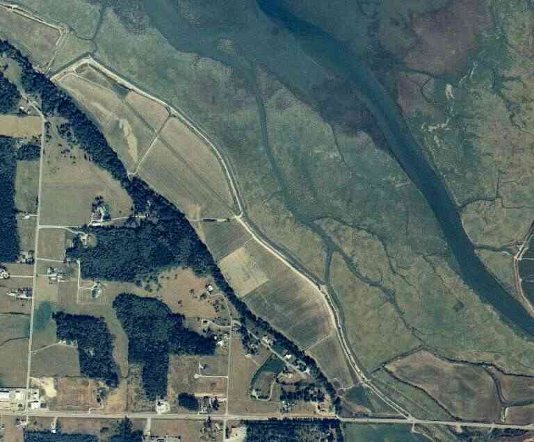
The above September 1997 aerial photo of this section of Camano is from http://www.islandcounty.net/publicworks/digitalphotos/mainmap.htm
The above September 1997 aerial photo of this section of Camano is from
http://www.islandcounty.net/publicworks/digitalphotos/mainmap.htm
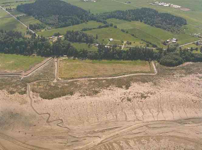
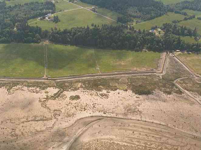
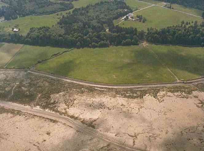
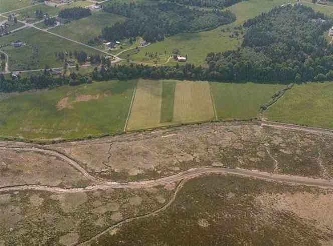
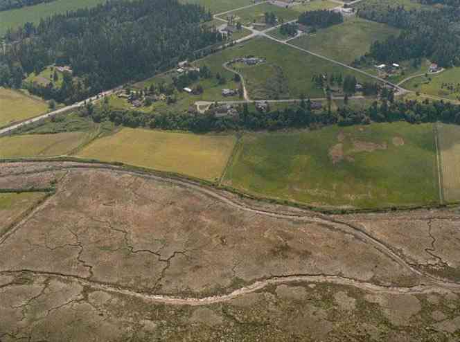
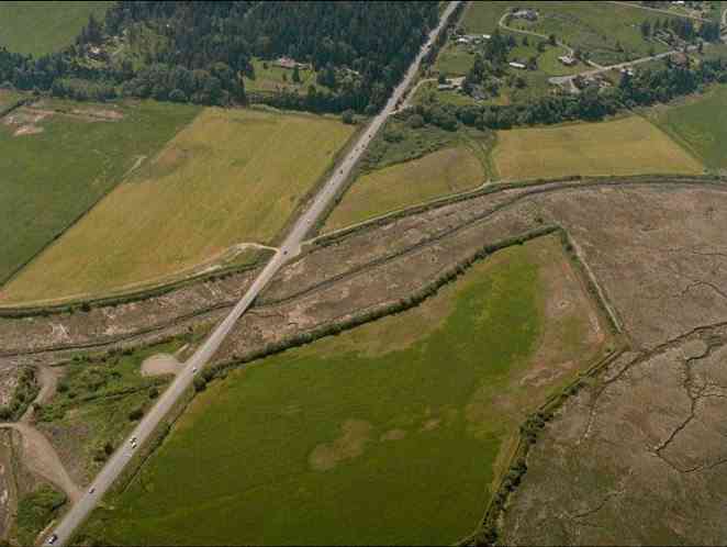
The below 5/11/1993 2:42:00 PM aerial photos are from:
http://apps.ecy.wa.gov/shorephotos
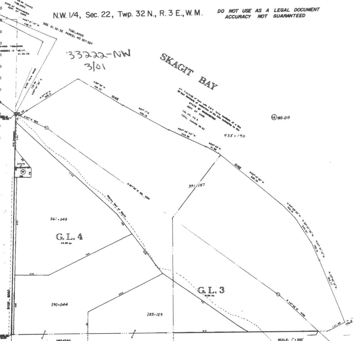
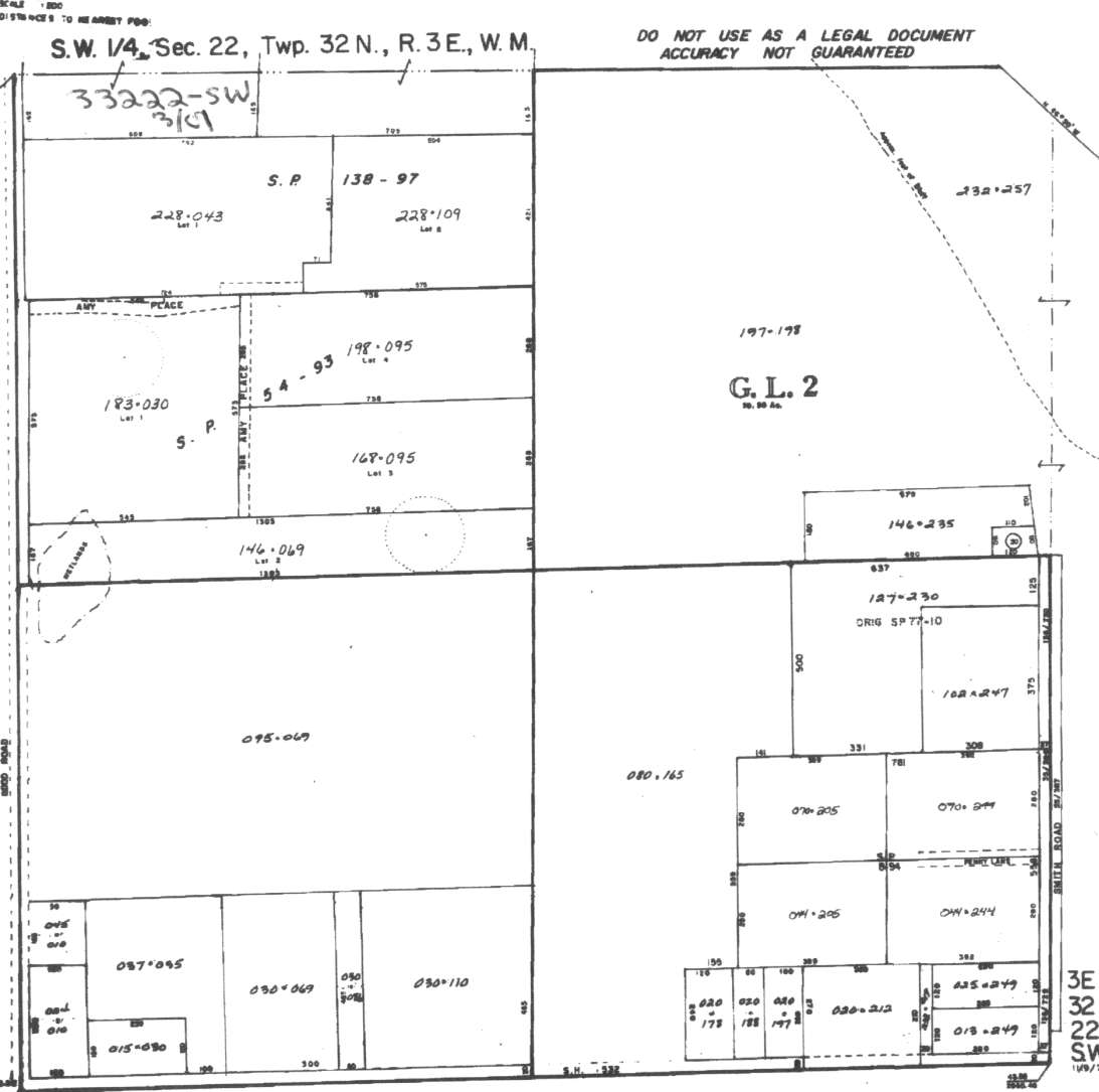
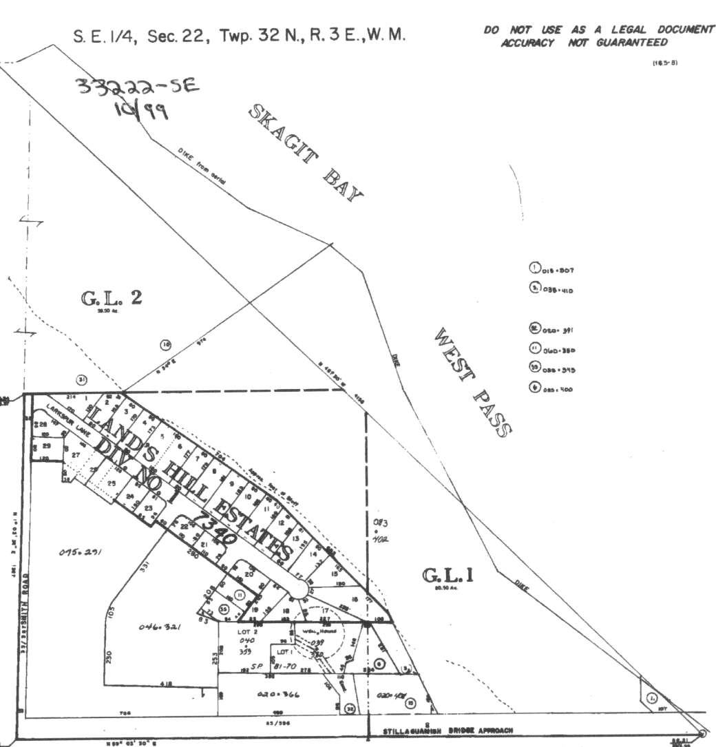
A square system of surveying was ordained by the Continental Congress on May 20, 1785. Within each township (6 miles X 6 miles), are 36 sections. Each section of 640 acres is one mile square (5,280 feet X 5,280 feet). Each quarter section is 160 acres (2,640 feet X 2,640 feet). Most long straight roads and acreage pieces of property have north-south, east-west property lines.
Click on the below Camano section map numbers, to go to a page with Camano Island 2005 assessor data, 1/4 section parcel maps, and aerial photos.
Below are the 15 well reports for this section of Camano, from the December 2004 Washington State Department of Ecology Well log website. Included below is who the well was drilled for, the well depth, and when the well was drilled. At the well log website,
http://apps.ecy.wa.gov/welllog/ more detailed information is available, like the well drillers name, water temperature(sometimes), and soil profile depths.
 <888>
<888>

1. RON~ KATHLEEN~ READY~ STAN S BERRYĀ - { view PDF
Ā|Ā view TIFF
}
Public Land Survey: NW, SW, S-22, T-32-N, R-03-E, Tax Parcel Number: R33222-175-103
County: ISLAND, Well Address: (blank)
Well Log ID: 339939, Well Tag ID: ABO604, Notice of Intent Number: W150887
Well Diameter: 6 (inches), Well Depth: 180 (feet)
Well Type: Water, Well Completion Date: 4/26/2002, Well Log Received Date: 5/29/2002
2. OMNI CONSTRUCTIONĀ - { view PDF
Ā|Ā view TIFF
}
Public Land Survey: SE, SW, S-22, T-32-N, R-03-E, Tax Parcel Number: 33222-044-2050
County: ISLAND, Well Address: 1378 PENNY LN, CAMANO ISLAND
Well Log ID: 314578, Well Tag ID: AGA255, Notice of Intent Number: W128731
Well Diameter: 6 (inches), Well Depth: 160 (feet)
Well Type: Water, Well Completion Date: 8/1/2001, Well Log Received Date: 8/21/2001
3. KEVIN JOHNSONĀ - { view PDF
Ā|Ā view TIFF
}
Public Land Survey: NW, SW, S-22, T-32-N, R-03-E, Tax Parcel Number: (blank)
County: ISLAND, Well Address: 920 AMY PL CAMANO ISLAND
Well Log ID: 73752, Well Tag ID: ACY741, Notice of Intent Number: W099611
Well Diameter: 6 (inches), Well Depth: 172.5 (feet)
Well Type: Water, Well Completion Date: 1/18/1999, Well Log Received Date: 1/21/1999
4. DALE GOSHORNĀ - { view PDF
Ā|Ā view TIFF
}
Public Land Survey: SE, NW, S-22, T-32-N, R-03-E, Tax Parcel Number: (blank)
County: SNOHOMISH, Well Address: 920 N AMY PL, STANWOOD, 98292
Well Log ID: 87423, Well Tag ID: ACY321, Notice of Intent Number: W103987
Well Diameter: 6 (inches), Well Depth: 147 (feet)
Well Type: Water, Well Completion Date: 8/20/1998, Well Log Received Date: 9/14/1998
5. UTSALADY RD. SLOPE INDĀ - { view PDF
Ā|Ā view TIFF
}
Public Land Survey: NE, NW, S-22, T-32-N, R-03-E, Tax Parcel Number: (blank)
County: ISLAND, Well Address: (blank)
Well Log ID: 119542, Well Tag ID: (blank) , Notice of Intent Number: R027851
Well Diameter: 9 (inches), Well Depth: (blank)
Well Type: Resource Protection, Well Completion Date: 1/18/1997, Well Log Received Date: 3/7/1997
6. ROB CLEMENSĀ - { view PDF
Ā|Ā view TIFF
}
Public Land Survey: NW, SW, S-22, T-32-N, R-03-E, Tax Parcel Number: (blank)
County: ISLAND, Well Address: 930 N AMY PL, CAMANO ISLAND
Well Log ID: 69888, Well Tag ID: (blank) , Notice of Intent Number: W043591
Well Diameter: 6 (inches), Well Depth: 198 (feet)
Well Type: Water, Well Completion Date: 5/5/1995, Well Log Received Date: 6/19/1995
7. BYRON KESLERĀ - { view PDF
Ā|Ā view TIFF
}
Public Land Survey: SE, SW, S-22, T-32-N, R-03-E, Tax Parcel Number: (blank)
County: ISLAND, Well Address: SMITH RD, CAMANO ISLAND
Well Log ID: 62135, Well Tag ID: (blank) , Notice of Intent Number: W009646
Well Diameter: 6 (inches), Well Depth: 150 (feet)
Well Type: Water, Well Completion Date: 11/29/1993, Well Log Received Date: 12/6/1993
8. LINN EMRICHĀ - { view PDF
Ā|Ā view TIFF
}
Public Land Survey: SW, NW, S-22, T-32-N, R-03-E, Tax Parcel Number: (blank)
County: ISLAND, Well Address: 1002 GOOD RD, CAMANO ISLAND
Well Log ID: 67315, Well Tag ID: (blank) , Notice of Intent Number: 200496
Well Diameter: 6 (inches), Well Depth: 175 (feet)
Well Type: Water, Well Completion Date: 8/14/1992, Well Log Received Date: 8/20/1992
9. TRANS MOUNTAIN PIPELINEĀ - { view PDF
Ā|Ā view TIFF
}
Public Land Survey: SE, NE, S-22, T-32-N, R-03-E, Tax Parcel Number: (blank)
County: ISLAND, Well Address: TRANS MOUNTAIN OIL PIPELINE
Well Log ID: 119325, Well Tag ID: (blank) , Notice of Intent Number: 065606
Well Diameter: 10 (inches), Well Depth: (blank)
Well Type: Resource Protection, Well Completion Date: 7/12/1991, Well Log Received Date: 7/22/1991
10. LEE WHITESIDEĀ - { view PDF
Ā|Ā view TIFF
}
Public Land Survey: SW, SW, S-22, T-32-N, R-03-E, Tax Parcel Number: (blank)
County: ISLAND, Well Address: (blank)
Well Log ID: 67186, Well Tag ID: (blank) , Notice of Intent Number: (blank)
Well Diameter: 6 (inches), Well Depth: 214 (feet)
Well Type: Water, Well Completion Date: 10/31/1978, Well Log Received Date: (blank)
11. BYRON KESLERĀ - { view PDF
Ā|Ā view TIFF
}
Public Land Survey: SE, SW, S-22, T-32-N, R-03-E, Tax Parcel Number: (blank)
County: ISLAND, Well Address: PENNY LN, CAMANO ISLAND
Well Log ID: 62136, Well Tag ID: (blank) , Notice of Intent Number: W077741
Well Diameter: 6 (inches), Well Depth: 151 (feet)
Well Type: Water, Well Completion Date: 5/19/1978, Well Log Received Date: (blank)
12. LANDS HILL ESTATESĀ - { view PDF
Ā|Ā view TIFF
}
Public Land Survey: SW, SE, S-22, T-32-N, R-03-E, Tax Parcel Number: (blank)
County: ISLAND, Well Address: (blank)
Well Log ID: 66993, Well Tag ID: AGA773, Notice of Intent Number: (blank)
Well Diameter: 6 (inches), Well Depth: 150 (feet)
Well Type: Water, Well Completion Date: 9/24/1965, Well Log Received Date: 9/1/1989
13. LAWDS HILL ESTATESĀ - { view PDF
Ā|Ā view TIFF
}
Public Land Survey: SW, SE, S-22, T-32-N, R-03-E, Tax Parcel Number: (blank)
County: ISLAND, Well Address: (blank)
Well Log ID: 67122, Well Tag ID: (blank) , Notice of Intent Number: (blank)
Well Diameter: 6 (inches), Well Depth: 150 (feet)
Well Type: Water, Well Completion Date: 9/24/1965, Well Log Received Date: 9/1/1989
14. CAMANO GATEWAY INCĀ - { view PDF
Ā|Ā view TIFF
}
Public Land Survey: SW, SW, S-22, T-32-N, R-03-E, Tax Parcel Number: (blank)
County: ISLAND, Well Address: (blank)
Well Log ID: 351191, Well Tag ID: (blank) , Notice of Intent Number: (blank)
Well Diameter: 6 (inches), Well Depth: 186 (feet)
Well Type: Water, Well Completion Date: 7/16/1959, Well Log Received Date: (blank)
15. MARTIN JOHNSONĀ - { view PDF
Ā|Ā view TIFF
}
Public Land Survey: (blank), (blank), S-22, T-32-N, R-03-E, Tax Parcel Number: (blank)
County: ISLAND, Well Address: (blank)
Well Log ID: 67693, Well Tag ID: (blank) , Notice of Intent Number: (blank)
Well Diameter: 6 (inches), Well Depth: 89 (feet)
Well Type: Water, Well Completion Date: 7/15/1952, Well Log Received Date: (blank)