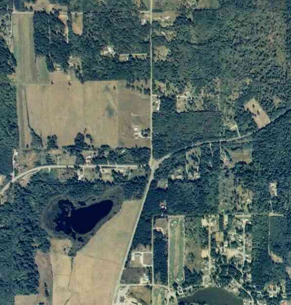
The above September 1997 aerial photo of this section of Camano is from http://www.islandcounty.net/publicworks/digitalphotos/mainmap.htm
The above September 1997 aerial photo of this section of Camano is from
http://www.islandcounty.net/publicworks/digitalphotos/mainmap.htm
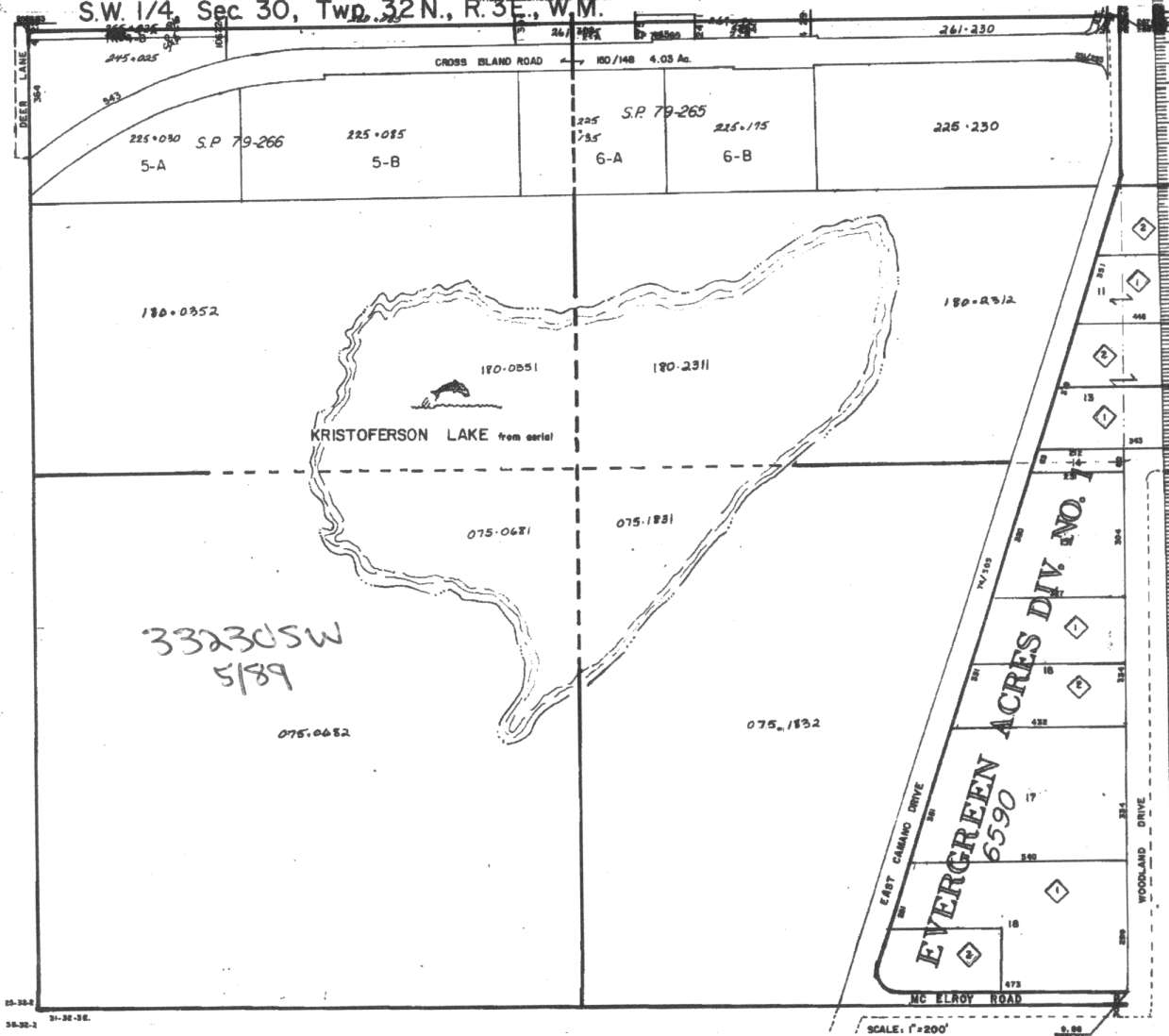
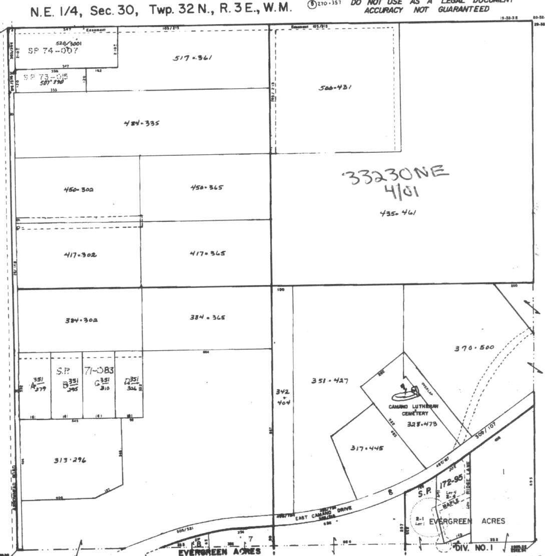
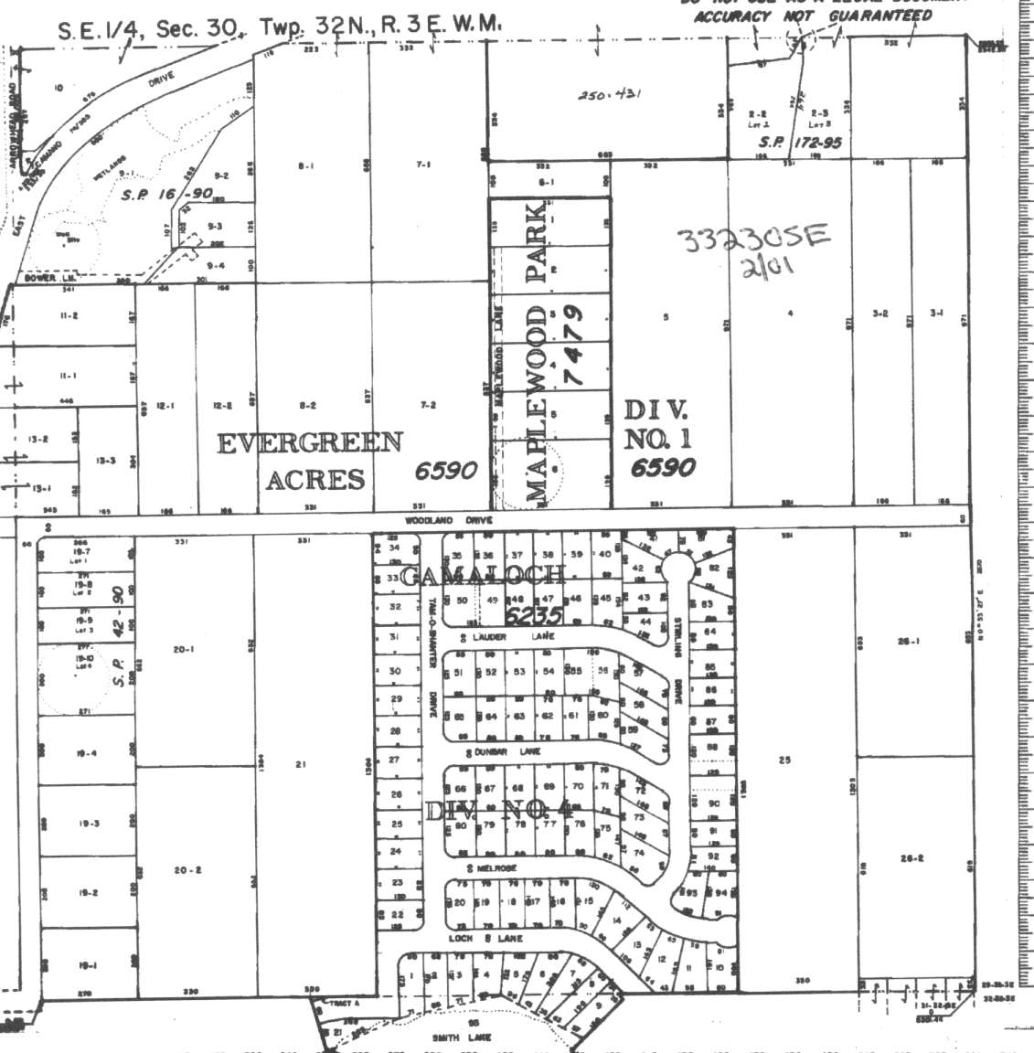
A square system of surveying was ordained by the Continental Congress on May 20, 1785. Within each township (6 miles X 6 miles), are 36 sections. Each section of 640 acres is one mile square (5,280 feet X 5,280 feet). Each quarter section is 160 acres (2,640 feet X 2,640 feet). Most long straight roads and acreage pieces of property have north-south, east-west property lines.
Click on the below Camano section map numbers, to go to a page with Camano Island 2005 assessor data, 1/4 section parcel maps, and aerial photos.
Below are the 25 well reports for this section of Camano, from the December 2004 Washington State Department of Ecology Well log website. Included below is who the well was drilled for, the well depth, and when the well was drilled. At the well log website,
http://apps.ecy.wa.gov/welllog/ more detailed information is available, like the well drillers name, water temperature(sometimes), and soil profile depths.

 <888>
<888>

1. DARLENE SEEĀ - { view PDF
Ā|Ā view TIFF
}
Public Land Survey: NW, NE, S-30, T-32-N, R-03-E, Tax Parcel Number: (blank)
County: ISLAND, Well Address: 740 N ARROWHEAD RD, CAMANO ISLAND
Well Log ID: 357491, Well Tag ID: AGK744, Notice of Intent Number: W120920
Well Diameter: 6 (inches), Well Depth: 339 (feet)
Well Type: Water, Well Completion Date: 4/3/2003, Well Log Received Date: 4/10/2003
2. LEONNE JOHNSONĀ - { view PDF
Ā|Ā view TIFF
}
Public Land Survey: NW, SE, S-30, T-32-N, R-03-E, Tax Parcel Number: (blank)
County: ISLAND, Well Address: XXX WOODLAND DR, CAMANO ISLAND
Well Log ID: 305321, Well Tag ID: AFK009, Notice of Intent Number: W120068
Well Diameter: 6 (inches), Well Depth: 240 (feet)
Well Type: Water, Well Completion Date: 3/13/2001, Well Log Received Date: 4/18/2001
3. CHARLIE SHIRLEYĀ - { view PDF
Ā|Ā view TIFF
}
Public Land Survey: SE, SE, S-30, T-32-N, R-03-E, Tax Parcel Number: (blank)
County: ISLAND, Well Address: 369 WOODLAND DR, CAMANO ISLAND, 98282
Well Log ID: 305323, Well Tag ID: AFJ927, Notice of Intent Number: W127818
Well Diameter: 6 (inches), Well Depth: 260 (feet)
Well Type: Water, Well Completion Date: 1/24/2001, Well Log Received Date: 3/6/2001
4. CARL GARRISONĀ - { view PDF
Ā|Ā view TIFF
}
Public Land Survey: SW, NE, S-30, T-32-N, R-03-E, Tax Parcel Number: (blank)
County: ISLAND, Well Address: (blank)
Well Log ID: 247296, Well Tag ID: AEP840, Notice of Intent Number: R038525
Well Diameter: 2 (inches), Well Depth: 8 (feet)
Well Type: Resource Protection, Well Completion Date: 7/20/2000, Well Log Received Date: 8/15/2000
5. CARL GARRISONĀ - { view PDF
Ā|Ā view TIFF
}
Public Land Survey: SW, NE, S-30, T-32-N, R-03-E, Tax Parcel Number: (blank)
County: ISLAND, Well Address: (blank)
Well Log ID: 247297, Well Tag ID: AEP841, Notice of Intent Number: R038525
Well Diameter: 2 (inches), Well Depth: 30 (feet)
Well Type: Resource Protection, Well Completion Date: 7/20/2000, Well Log Received Date: 8/15/2000
6. STEVE REDFERNĀ - { view PDF
Ā|Ā view TIFF
}
Public Land Survey: NW, NW, S-30, T-32-N, R-03-E, Tax Parcel Number: (blank)
County: ISLAND, Well Address: 770 ELDERBERRY LN CAMANO IS WA
Well Log ID: 247759, Well Tag ID: AFK003, Notice of Intent Number: W120062
Well Diameter: 6 (inches), Well Depth: 300 (feet)
Well Type: Water, Well Completion Date: 6/16/2000, Well Log Received Date: 8/3/2000
7. DALE YUSTĀ - { view PDF
Ā|Ā view TIFF
}
Public Land Survey: (blank), SE, S-30, T-32-N, R-03-E, Tax Parcel Number: (blank)
County: ISLAND, Well Address: 617 ARROWHEAD RD
Well Log ID: 190612, Well Tag ID: AER453, Notice of Intent Number: W118451
Well Diameter: 6 (inches), Well Depth: 240 (feet)
Well Type: Water, Well Completion Date: 8/2/1999, Well Log Received Date: 8/24/1999
8. CAROLYN WATTS / LARRY MORTENSONĀ - { view PDF
Ā|Ā view TIFF
}
Public Land Survey: NE, SE, S-30, T-32-N, R-03-E, Tax Parcel Number: (blank)
County: ISLAND, Well Address: WOODLAND DR, CAMANO IS
Well Log ID: 123099, Well Tag ID: AEG542, Notice of Intent Number: 100784
Well Diameter: 6 (inches), Well Depth: 218 (feet)
Well Type: Water, Well Completion Date: 4/21/1999, Well Log Received Date: 5/18/1999
9. BOB DE-YOUNGĀ - { view PDF
Ā|Ā view TIFF
}
Public Land Survey: NE, SE, S-30, T-32-N, R-03-E, Tax Parcel Number: (blank)
County: ISLAND, Well Address: (blank)
Well Log ID: 248160, Well Tag ID: AEP234, Notice of Intent Number: W093347
Well Diameter: 6 (inches), Well Depth: 270 (feet)
Well Type: Water, Well Completion Date: 4/14/1999, Well Log Received Date: 4/30/1999
10. JODY ERICKSONĀ - { view PDF
Ā|Ā view TIFF
}
Public Land Survey: NW, NE, S-30, T-32-N, R-03-E, Tax Parcel Number: (blank)
County: ISLAND, Well Address: WOODLAND RD, CAMANO ISLAND
Well Log ID: 72636, Well Tag ID: ABC726, Notice of Intent Number: W075090
Well Diameter: 6 (inches), Well Depth: 320 (feet)
Well Type: Water, Well Completion Date: 5/8/1998, Well Log Received Date: 6/1/1998
11. ROB DAVISĀ - { view PDF
Ā|Ā view TIFF
}
Public Land Survey: NE, NW, S-30, T-32-N, R-03-E, Tax Parcel Number: (blank)
County: ISLAND, Well Address: 154 LINDSEY RD, CAMANO ISLAND
Well Log ID: 69891, Well Tag ID: (blank) , Notice of Intent Number: W075085
Well Diameter: 6 (inches), Well Depth: 240 (feet)
Well Type: Water, Well Completion Date: 12/23/1997, Well Log Received Date: 3/5/1998
12. ROGER & LISA REYNOLDSĀ - { view PDF
Ā|Ā view TIFF
}
Public Land Survey: SE, SE, S-30, T-32-N, R-03-E, Tax Parcel Number: (blank)
County: ISLAND, Well Address: 380 E WOODLAND DR, CAMANO ISLAND, 98292
Well Log ID: 70123, Well Tag ID: (blank) , Notice of Intent Number: W074172
Well Diameter: 6 (inches), Well Depth: 284 (feet)
Well Type: Water, Well Completion Date: 12/11/1997, Well Log Received Date: 2/11/1998
13. DANE & CINDY PENERYĀ - { view PDF
Ā|Ā view TIFF
}
Public Land Survey: NE, SW, S-30, T-32-N, R-03-E, Tax Parcel Number: (blank)
County: ISLAND, Well Address: CROSS ISLAND AND ARROWHEAD
Well Log ID: 62911, Well Tag ID: (blank) , Notice of Intent Number: W073040
Well Diameter: 6 (inches), Well Depth: 247 (feet)
Well Type: Water, Well Completion Date: 9/19/1996, Well Log Received Date: 9/24/1996
14. PATRICIA KRISTOFERSONĀ - { view PDF
Ā|Ā view TIFF
}
Public Land Survey: SW, SW, S-30, T-32-N, R-03-E, Tax Parcel Number: (blank)
County: ISLAND, Well Address: 398 E CAMANO DR, CAMANO ISLAND, 98292
Well Log ID: 69042, Well Tag ID: (blank) , Notice of Intent Number: W064590
Well Diameter: 6 (inches), Well Depth: 132 (feet)
Well Type: Water, Well Completion Date: 8/31/1996, Well Log Received Date: 9/9/1996
15. F. MARK BRUNNER / T. SCOTT LANGBERGĀ - { view PDF
Ā|Ā view TIFF
}
Public Land Survey: SE, SW, S-30, T-32-N, R-03-E, Tax Parcel Number: (blank)
County: ISLAND, Well Address: E WOODLAND DR, CAMANO ISLAND
Well Log ID: 72792, Well Tag ID: ABM076, Notice of Intent Number: W018115
Well Diameter: 6 (inches), Well Depth: 274 (feet)
Well Type: Water, Well Completion Date: 7/26/1996, Well Log Received Date: 8/28/1996
16. BASIL CHORNEYĀ - { view PDF
Ā|Ā view TIFF
}
Public Land Survey: SE, SE, S-30, T-32-N, R-03-E, Tax Parcel Number: (blank)
County: ISLAND, Well Address: 221 E WOODLAND DR, CAMANO ISLAND, 98292
Well Log ID: 61421, Well Tag ID: (blank) , Notice of Intent Number: W010544
Well Diameter: 6 (inches), Well Depth: 232 (feet)
Well Type: Water, Well Completion Date: 7/23/1993, Well Log Received Date: 8/17/1993
17. GARY POLLOCKĀ - { view PDF
Ā|Ā view TIFF
}
Public Land Survey: SE, NW, S-30, T-32-N, R-03-E, Tax Parcel Number: (blank)
County: ISLAND, Well Address: 770 ARROWHEAD RD, CAMANO ISLAND, 98292
Well Log ID: 64508, Well Tag ID: (blank) , Notice of Intent Number: 210058
Well Diameter: 6 (inches), Well Depth: 216 (feet)
Well Type: Water, Well Completion Date: 5/12/1993, Well Log Received Date: 5/18/1993
18. CHUCK PATTERSONĀ - { view PDF
Ā|Ā view TIFF
}
Public Land Survey: SE, SE, S-30, T-32-N, R-03-E, Tax Parcel Number: (blank)
County: ISLAND, Well Address: WOODLAND DR
Well Log ID: 62466, Well Tag ID: (blank) , Notice of Intent Number: 070875
Well Diameter: 6 (inches), Well Depth: 213 (feet)
Well Type: Water, Well Completion Date: 3/9/1993, Well Log Received Date: (blank)
19. JOHN WINTERSĀ - { view PDF
Ā|Ā view TIFF
}
Public Land Survey: NW, SE, S-30, T-32-N, R-03-E, Tax Parcel Number: (blank)
County: ISLAND, Well Address: WOODLAWN, CAMANO ISLAND
Well Log ID: 66520, Well Tag ID: (blank) , Notice of Intent Number: (blank)
Well Diameter: 6 (inches), Well Depth: 259 (feet)
Well Type: Water, Well Completion Date: 9/1/1992, Well Log Received Date: 9/28/1992
20. TERRY SCHLOSSERĀ - { view PDF
Ā|Ā view TIFF
}
Public Land Survey: NW, NW, S-30, T-32-N, R-03-E, Tax Parcel Number: (blank)
County: ISLAND, Well Address: ELDERBERRY LN AND LINDSAY
Well Log ID: 71046, Well Tag ID: (blank) , Notice of Intent Number: (blank)
Well Diameter: 6 (inches), Well Depth: 298 (feet)
Well Type: Water, Well Completion Date: 8/26/1992, Well Log Received Date: 9/11/1992
21. GTEĀ - { view PDF
Ā|Ā view TIFF
}
Public Land Survey: SE, SW, S-30, T-32-N, R-03-E, Tax Parcel Number: (blank)
County: ISLAND, Well Address: CROSS ISLAND
Well Log ID: 64947, Well Tag ID: (blank) , Notice of Intent Number: (blank)
Well Diameter: 6 (inches), Well Depth: 200 (feet)
Well Type: Water, Well Completion Date: 6/25/1992, Well Log Received Date: 7/2/1992
22. GARY STAFERĀ - { view PDF
Ā|Ā view TIFF
}
Public Land Survey: NW, SE, S-30, T-32-N, R-03-E, Tax Parcel Number: (blank)
County: ISLAND, Well Address: 540 NE CAMANO DR, CAMANO ISLAND
Well Log ID: 64522, Well Tag ID: (blank) , Notice of Intent Number: 073284
Well Diameter: 6 (inches), Well Depth: 120 (feet)
Well Type: Water, Well Completion Date: 4/1/1992, Well Log Received Date: 4/7/1992
23. CURT CUMMINGSĀ - { view PDF
Ā|Ā view TIFF
}
Public Land Survey: SE, SW, S-30, T-32-N, R-03-E, Tax Parcel Number: (blank)
County: ISLAND, Well Address: LINDSY RD
Well Log ID: 62697, Well Tag ID: (blank) , Notice of Intent Number: 078383
Well Diameter: 6 (inches), Well Depth: 198 (feet)
Well Type: Water, Well Completion Date: 5/9/1991, Well Log Received Date: 5/31/1991
24. EUGENE AUSTĀ - { view PDF
Ā|Ā view TIFF
}
Public Land Survey: SE, NW, S-30, T-32-N, R-03-E, Tax Parcel Number: (blank)
County: ISLAND, Well Address: 810 N MARTIN RD, CAMANO ISLAND
Well Log ID: 64121, Well Tag ID: (blank) , Notice of Intent Number: 016765
Well Diameter: 6 (inches), Well Depth: 75 (feet)
Well Type: Water, Well Completion Date: 9/29/1988, Well Log Received Date: 10/7/1988
25. JERRY MOXLEYĀ - { view PDF
Ā|Ā view TIFF
}
Public Land Survey: SW, NW, S-30, T-32-N, R-03-E, Tax Parcel Number: (blank)
County: ISLAND, Well Address: (blank)
Well Log ID: 65845, Well Tag ID: AGA504, Notice of Intent Number: (blank)
Well Diameter: 6 (inches), Well Depth: 215 (feet)
Well Type: Water, Well Completion Date: 9/2/1988, Well Log Received Date: 9/8/1988